اتوا (ضلع)
| ضلع | |
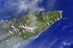
 Satellite image of eastern side of Upolu island with tiny islands off the coast. (ناسا photo, 2006) | |
 Map of Samoa showing Atua district | |
| ملک | |
| منطقۂ وقت | -11 |
اتوا (ضلع) (انگریزی: Atua (district)) سامووا کا ایک administrative territorial entity of a single country جو سامووا میں واقع ہے۔[1]
مزید دیکھیے[ترمیم]
حوالہ جات[ترمیم]
- ↑ انگریزی ویکیپیڈیا کے مشارکین۔ "Atua (district)"
|
|
