
فائل:Beginning Point of the U.S. Public Land Survey front.jpg

اس نمائش کا حجم: 450 × 600 پکسلز۔ دیگر تصمیمات: 180 × 240 پکسلز | 360 × 480 پکسلز | 576 × 768 پکسلز | 768 × 1,024 پکسلز | 2,112 × 2,816 پکسلز۔
اصل فائل (2,112 × 2,816 پکسل، فائل کا حجم: 3.37 MB، MIME قسم: image/jpeg)
|
This is an image of a place or building that is listed on the National Register of Historic Places in the United States of America. Its reference number is 66000606. |
| Camera location | | View this and other nearby images on: OpenStreetMap |
|---|
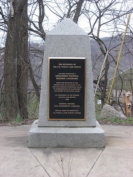
| تفصیل | Streetside view of the Beginning Point of the U.S. Public Land Survey, a monument marking the site that served as the basis for the entire Public Land Survey System — the system by which most of the United States, outside of the original colonies, was surveyed. Located on the Ohio/Pennsylvania border east of downtown East Liverpool, Ohio, it is split between the city of East Liverpool and the borough of Ohioville in Beaver County, Pennsylvania. Erected in 1881 by a joint commission of Ohio and Pennsylvania surveyors, the monument was declared a National Historic Landmark in 1966. The road on which it lies is Ohio State Route 39 and Pennsylvania Route 68. | ||
| تاریخ | Taken on 28 مارچ 2009 | ||
| ماخذ | ذاتی کام | ||
| مصنف | User:Nyttend | ||
| اجازت (فائل کا دوبارہ استعمال) |
|
||
| دوسرے نسخے |
 Ohio and Ohio and  Pennsylvania sides of the monument Pennsylvania sides of the monument |
فائل کا تاریخچہ
کسی خاص وقت یا تاریخ میں یہ فائل کیسی نظر آتی تھی، اسے دیکھنے کے لیے اس وقت/تاریخ پر کلک کریں۔
| تاریخ/وقت | تھمب نیل | ابعاد | صارف | تبصرہ | |
|---|---|---|---|---|---|
| رائج الوقت | 04:29، 28 مارچ 2009ء | | 2,112 × 2,816 (3.37 MB) | Nyttend | {{Location|40|38|33|N|80|31|10|W}} {{Information |Description=Streetside view of the {{w|Beginning Point of the U.S. Public Land Survey}}, a monument marking the site that served as the basis for the entire {{w|Public Land Survey System}} — the system b |
روابط
درج ذیل صفحہ اس فائل کو استعمال کر رہا ہے:
فائل کا عالمی استعمال
مندرجہ ذیل ویکیوں میں یہ فائل زیر استعمال ہے:
- ca.wikipedia.org پر استعمال
- de.wikipedia.org پر استعمال
- en.wikipedia.org پر استعمال
- Public Land Survey System
- List of Historic Civil Engineering Landmarks
- Point of beginning
- List of National Historic Landmarks in Pennsylvania
- List of National Historic Landmarks in Ohio
- Beginning Point of the U.S. Public Land Survey
- National Register of Historic Places listings in Columbiana County, Ohio
- National Register of Historic Places listings in Beaver County, Pennsylvania
- List of Pennsylvania state historical markers in Beaver County
- User talk:Dthomsen8/List PA Test
- en.wikivoyage.org پر استعمال
- es.wikipedia.org پر استعمال
- fr.wikipedia.org پر استعمال
- hu.wikipedia.org پر استعمال
- it.wikipedia.org پر استعمال
- ja.wikipedia.org پر استعمال
- pt.wikipedia.org پر استعمال
- tl.wikipedia.org پر استعمال
- vi.wikipedia.org پر استعمال
- www.wikidata.org پر استعمال