
فائل:Golan Heights relief v2.png

اس نمائش کا حجم: 522 × 600 پکسلز۔ دیگر تصمیمات: 209 × 240 پکسلز | 418 × 480 پکسلز | 758 × 871 پکسلز۔
اصل فائل (758 × 871 پکسل، فائل کا حجم: 923 کلوبائٹ، MIME قسم: image/png)
خلاصہ
| تفصیل |
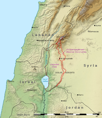
English: This is a shaded relief map illustrating the topography of the Golan Heights and surrounding areas. Transverse Mercator projection (EPSG: 2039) Source data: * Elevation data: SRTM data from NASA[1] * Borders, cities, and geographic features: The Natural Earth
العربية: هذه خريطة مجسمة مظللة توضح تضاريس هضبة الجولان والمناطق المحيطة بها ومآل مناطق النزاع على الحدود بين سوريا وإسرائيل. الإحداثيات حسب نظام إسقاط ميركاتور المستعرض (EPSG: 2039)
مصدر البيانات:
|
| تاریخ | (UTC) |
| ماخذ | |
| مصنف |
|
| دوسرے نسخے | File:Golan Heights geography.png |

|
This map image could be re-created using vector graphics as an SVG file. This has several advantages; see Commons:Media for cleanup for more information. If an SVG form of this image is available, please upload it and afterwards replace this template with
{{vector version available|new image name}}.
It is recommended to name the SVG file “Golan Heights relief v2.svg”—then the template Vector version available (or Vva) does not need the new image name parameter. |
| This is a retouched picture, which means that it has been digitally altered from its original version. Modifications: Adjusted borders to prioritise internationally recognised borders.. The original can be viewed here: Golan Heights relief v1.jpg:
|
اجازہ کاری
میں اس کام کا کاپی رائٹ ہولڈر ہوں اور اسے مندرجہ ذیل اجازت ناموں کے تحت شائع کیا ہے:
اس ملف کا لائسنس Creative Commons Attribution-Share Alike 3.0 Unported کے تحط ہے۔
- آپ آزاد ہیں:
- شیئر کرنے – کام کو نقل، تقسیم یا منتقل کرنے کے لیے
- ریمکس کے لیے – کام منبطق کرنے کے لیے
- مندرجہ ذیل شرائط کے تحت:
- انتساب – آپ کو اس کام کا انتساب مصنف یا اجازت دہندہ کے بتائے گئے طریقہ کے مطابق دینا ہوگا (تاہم یہ انتساب اس طرح نہیں ہونا چاہیے کہ اسے دیکھ کر ایسا محسوس ہو کہ اصل مصنف یا اجازت دہندہ آپ کے یا آپ کے ذریعہ اس کام کے استعمال کرنے کے حامی ہیں)۔
- یکساں شراکت – اگر آپ اس کام میں کوئی تبدیلی یا ترمیم کرتے ہیں یا اس کام پر مبنی کچھ نیا بناتے ہیں تو اسے بھی آپ اسی یا اس جیسے کسی اجازت نامے کے تحت شائع کر سکتے ہیں۔

|
آپ کو آزاد سافٹ ویئر فاؤنڈیشن کی جانب سے شائع کردہ جی این یو آزاد مسوداتی اجازت نامہ کی شرائط استعمال کے تحت اس دستاویز کو نقل، تقسیم اور/ یا ترمیم کرنے کی اجازت دی جاتی ہے۔ اس اجازت نامہ کی ایک نقل 'جی این یو آزاد مسوداتی اجازت نامہ کے عنوان سے میسر ہے۔ |
آپ حسب منشا اجازت نامہ منتخب کر سکتے ہیں۔
اولین اپلوڈ کا نوشتہ
This image is a derivative work of the following images:
- File:Golan_Heights_relief_v1.jpg licensed with Cc-by-sa-3.0, GFDL
- 2011-03-15T03:27:39Z Kbh3rd 758x871 (279344 Bytes) With "Golan Heights" labeled, from original layers to avoid quality issues with Chesdovi's edit
- 2011-03-09T15:33:27Z Chesdovi 615x605 (161970 Bytes) Adding GOLAN HEIGHTS wording
- 2011-01-24T03:44:15Z Kbh3rd 758x871 (278034 Bytes) {{Information |Description ={{en|1=This is a [[:en:shaded relief|shaded relief]] map illustrating the topography of the [[:en:Golan Heights|Golan Heights]] and surrounding areas. Transverse Mercator projection (EPSG: 2039
Uploaded with derivativeFX
فائل کا تاریخچہ
کسی خاص وقت یا تاریخ میں یہ فائل کیسی نظر آتی تھی، اسے دیکھنے کے لیے اس وقت/تاریخ پر کلک کریں۔
| تاریخ/وقت | تھمب نیل | ابعاد | صارف | تبصرہ | |
|---|---|---|---|---|---|
| رائج الوقت | 06:27، 29 نومبر 2011ء | | 758 × 871 (923 کلوبائٹ) | Night w | == {{int:filedesc}} == {{Information |Description={{en|1=This is a shaded relief map illustrating the topography of the Golan Heights and surrounding areas. Transverse Mercator projection (EPSG: |
روابط
درج ذیل صفحہ اس فائل کو استعمال کر رہا ہے:
فائل کا عالمی استعمال
مندرجہ ذیل ویکیوں میں یہ فائل زیر استعمال ہے:
- ar.wikipedia.org پر استعمال
- ca.wikipedia.org پر استعمال
- ceb.wikipedia.org پر استعمال
- de.wikipedia.org پر استعمال
- el.wikipedia.org پر استعمال
- en.wikipedia.org پر استعمال
- eo.wikipedia.org پر استعمال
- es.wikipedia.org پر استعمال
- eu.wikipedia.org پر استعمال
- fa.wikipedia.org پر استعمال
- fr.wikipedia.org پر استعمال
- hi.wikibooks.org پر استعمال
- hu.wikipedia.org پر استعمال
- hyw.wikipedia.org پر استعمال
- id.wikipedia.org پر استعمال
- it.wikipedia.org پر استعمال
- ja.wikipedia.org پر استعمال
- kn.wikipedia.org پر استعمال
- ml.wikipedia.org پر استعمال
- nl.wikipedia.org پر استعمال
- os.wikipedia.org پر استعمال
- pt.wikipedia.org پر استعمال
- ru.wikipedia.org پر استعمال
اس فائل کا مزید عالمی استعمال دیکھیے۔