
فائل:Gorno badakhshan map.png

اس نمائش کا حجم: 800 × 598 پکسلز۔ دیگر تصمیمات: 320 × 239 پکسلز | 640 × 479 پکسلز | 948 × 709 پکسلز۔
اصل فائل (948 × 709 پکسل، فائل کا حجم: 20 کلوبائٹ، MIME قسم: image/png)

|
This file requires updating because: The China-Tajikistan border has changed. In doing so, you could add a timestamp to the file.
|
خلاصہ
| تفصیل |
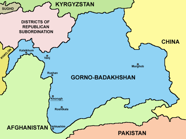
English: Map of Gorno-Badakhshan. |
| تاریخ | |
| ماخذ | ذاتی کام |
| مصنف | PANONIAN |
اجازہ کاری
میں اس تخلیقی کام کے حقوق کا مالک ہوں اور اسے مندرجہ ذیل اجازت نامے کے تحت شائع کرتا ہوں:
| This file is made available under the Creative Commons CC0 1.0 Universal Public Domain Dedication. | |
| The person who associated a work with this deed has dedicated the work to the public domain by waiving all of their rights to the work worldwide under copyright law, including all related and neighboring rights, to the extent allowed by law. You can copy, modify, distribute and perform the work, even for commercial purposes, all without asking permission.
|
فائل کا تاریخچہ
کسی خاص وقت یا تاریخ میں یہ فائل کیسی نظر آتی تھی، اسے دیکھنے کے لیے اس وقت/تاریخ پر کلک کریں۔
| تاریخ/وقت | تھمب نیل | ابعاد | صارف | تبصرہ | |
|---|---|---|---|---|---|
| رائج الوقت | 21:15، 9 اگست 2023ء | | 948 × 709 (20 کلوبائٹ) | Lojwe | Cropped 2 % horizontally, 5 % vertically using CropTool with precise mode. |
| 04:08، 27 ستمبر 2021ء |  | 970 × 749 (57 کلوبائٹ) | GPinkerton | Reverted to version as of 09:58, 14 May 2013 (UTC) COM:CROP | |
| 17:25، 4 اپریل 2021ء |  | 970 × 749 (47 کلوبائٹ) | Claude Zygiel | Differenciate international boundaries (black) from administrative of Tadjikistan (grey) | |
| 09:58، 14 مئی 2013ء |  | 970 × 749 (57 کلوبائٹ) | PANONIAN | {{Information |Description ={{en|1=Map of Gorno-Badakhshan.}} |Source ={{own}} |Author =PANONIAN |Date =2013 |Permission = |other_versions = }} |
روابط
درج ذیل صفحہ اس فائل کو استعمال کر رہا ہے:
فائل کا عالمی استعمال
مندرجہ ذیل ویکیوں میں یہ فائل زیر استعمال ہے:
- be.wikipedia.org پر استعمال
- bg.wikipedia.org پر استعمال
- cs.wikipedia.org پر استعمال
- el.wikipedia.org پر استعمال
- en.wikipedia.org پر استعمال
- eo.wikipedia.org پر استعمال
- es.wikipedia.org پر استعمال
- et.wikipedia.org پر استعمال
- fa.wikipedia.org پر استعمال
- fi.wikipedia.org پر استعمال
- fr.wikipedia.org پر استعمال
- gl.wikipedia.org پر استعمال
- hi.wikipedia.org پر استعمال
- id.wikipedia.org پر استعمال
- incubator.wikimedia.org پر استعمال
- it.wikipedia.org پر استعمال
- kaa.wikipedia.org پر استعمال
- ko.wikipedia.org پر استعمال
- lt.wikipedia.org پر استعمال
- pl.wikipedia.org پر استعمال
- pnb.wikipedia.org پر استعمال
- ps.wikipedia.org پر استعمال
- pt.wikipedia.org پر استعمال
- sr.wikipedia.org پر استعمال
- sv.wikipedia.org پر استعمال
- ta.wikipedia.org پر استعمال
- tg.wikipedia.org پر استعمال
- tr.wikipedia.org پر استعمال
- uz.wikipedia.org پر استعمال
- vi.wikipedia.org پر استعمال
- xmf.wikipedia.org پر استعمال
- zh.wikipedia.org پر استعمال