سانتا کلارا، کیوبا
| Municipality | |
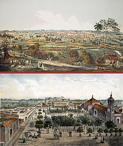
 Two views of Santa Clara painted by Leonardo Barañano and lithographed by famous French-Cuban artist Eduardo Laplante in 1858. Work appeared in the collections "Cuba pintoresca", "Isla de Cuba pintoresca" and "Album pintoresco de Cuba" printed between 1837 and 1858. | |
 Santa Clara municipality (red) within Villa Clara Province (yellow) and Cuba | |
| ملک | |
| Province | Villa Clara |
| سنہ تاسیس | July 15th, 1689 |
| قیام | January 1, 1690 |
| رقبہ | |
| • کل | 514 کلومیٹر2 (198 میل مربع) |
| بلندی | 125 میل (410 فٹ) |
| آبادی (2011) | |
| • کل | 219,660 |
| • کثافت | 430/کلومیٹر2 (1,100/میل مربع) |
| نام آبادی | Santaclareño |
| منطقۂ وقت | EST (UTC-5) |
| Postal code | 50100 |
| ٹیلی فون کوڈ | +53 422 |
سانتا کلارا، کیوبا ((ہسپانوی: Universidad Central "Marta Abreu" de Las Villas (UCLV))) ہے جو کیوبا میں واقع ہے۔ اس کی مجموعی آبادی 219,660 افراد پر مشتمل ہے، یہ ویا کلارا صوبہ میں واقع ہے۔[1]
نگار خانہ[ترمیم]
متعلقہ روابط[ترمیم]
حوالہ جات[ترمیم]
| ویکی ذخائر پر سانتا کلارا، کیوبا سے متعلق سمعی و بصری مواد ملاحظہ کریں۔ |
- ↑ انگریزی ویکیپیڈیا کے مشارکین۔ "Santa Clara, Cuba"


