انگولا ایئرسٹرپ
| انانکارپوریٹڈ علاقہ | |
| Louisiana State Penitentiary | |
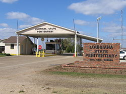
 The entrance to the Louisiana State Penitentiary has a guard house that controls entry into the compound—the sign says "Louisiana State Penitentiary" and "Burl Cain, Warden" | |
| عرفیت: "Angola", "Alcatraz of the South", and "The Farm" | |
| لوا خطا ماڈیول:Location_map میں 525 سطر پر: Unable to find the specified location map definition: "Module:Location map/data/Louisiana" does not exist۔Location in Louisiana | |
| متناسقات: 30°57′22″N 91°35′41″W / 30.95611°N 91.59472°W | |
| ملک | United States |
| ریاست | لوویزیانا |
| لوزیانا کے پیرشوں کی فہرست | ویسٹ فیلیشیانا پیرش، لوزیانا |
| بلندی Angola Landing is 43 ft | 15 میل (49 فٹ) |
| منطقۂ وقت | وسطی منطقۂ وقت (UTC-6) |
| • گرما (گرمائی وقت) | CDT (UTC-5) |
| زپ کوڈs | 70712 |
| ٹیلی فون کوڈ | 225 |
| جغرافیائی ناموں کا نظام معلومات feature ID | 553304 Angola Landing: 542930 |
| ویب سائٹ | doc.louisiana.gov/lsp/ |
| The above GNIS IDs are related to the "populated places". The GNIS ID for the Louisiana State Penentiary "locale" is 536752, the GNIS ID for the museum is 2603238, the GNIS ID for the fire department building is 2673017, and the GNIS ID for the adult school facility is 2434828. The GNIS for the previous Louisiana State Penitenitary building in بیٹون روج، لوزیانا is 552789. | |
انگولا ایئرسٹرپ (انگریزی: Louisiana State Penitentiary#Angola Airstrip) ریاستہائے متحدہ امریکا کا ایک رہائشی علاقہ جو لوویزیانا میں واقع ہے۔[1]
تفصیلات[ترمیم]
انگولا ایئرسٹرپ کی مجموعی آبادی 14.94 میٹر سطح سمندر سے بلندی پر واقع ہے۔
مزید دیکھیے[ترمیم]
حوالہ جات[ترمیم]
- ↑ انگریزی ویکیپیڈیا کے مشارکین۔ "Louisiana State Penitentiary#Angola Airstrip"
بیرونی روابط[ترمیم]
- ہوائی اڈوں کے بارے میں معلومات
- -نماياں-ہوائی-اڈے-کون-سے -رہے/g-42455746 2017ء ميں يورپ و مشرق وسطٰی کے نماياں ہوائی اڈے کون سے رہے
|
|
