
فائل:1811 Cary Map of Arabia, Egypt ^ Abyssinia - Geographicus - Arabia-cary-1811.jpg

اس نمائش کا حجم: 677 × 599 پکسلز۔ دیگر تصمیمات: 271 × 240 پکسلز | 542 × 480 پکسلز | 868 × 768 پکسلز | 1,157 × 1,024 پکسلز | 2,314 × 2,048 پکسلز | 4,000 × 3,540 پکسلز۔
اصل فائل (4,000 × 3,540 پکسل، فائل کا حجم: 2.84 MB، MIME قسم: image/jpeg)
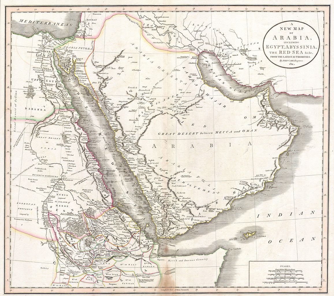
| John Cary: A New Map of Arabia, including Egypt, Abyssinia, the Red Sea & c. & c. from the latest Authorities.
( |
|||
|---|---|---|---|
| فن کار | |||
| عنوان |
A New Map of Arabia, including Egypt, Abyssinia, the Red Sea & c. & c. from the latest Authorities. |
||
| تفصیل |
English: This is a stunning 1811 map of Arabia, Egypt and Abyssinia ( Ethiopia ) by English Cartographer John Cary. A smorgasbord of wonderful detail including historical notes, caravan routes, the locations of desert wells and oases, nautical routes, and tribal kingdoms. Contains such notations as “Here the Portuguese found King David encamped in the Year 1520” , referring to the Portuguese embassy to the King of Ethiopia; “Myrrh and Incense Country” on the Horn of Africa; and “Supposed Island of Meroe”, referring to the ancient pyramid building culture in the heard of what is today Sudan. Also of interest is the route of the Frigate 'La Venus', which charted the Red Sea, the Persian Gulf, and the Indian Ocean before disappearing in a hurricane with all crew and cargo in 1788. Dated 1811. |
||
| تاریخ | 1811 | ||
| ابعاد | اونچائی: 18 in (45.7 cm)؛ اونچائی: 21 in (53.3 cm) | ||
| اضافہ نمبر |
Geographicus link: Arabia-cary-1811 |
||
| ماخذ/مصور |
|
||
| دوسرے نسخے |
|
||
.jpg)

اجازہ کاری
|
This is a faithful photographic reproduction of a two-dimensional, public domain work of art. The work of art itself is in the public domain for the following reason:
The official position taken by the Wikimedia Foundation is that "faithful reproductions of two-dimensional public domain works of art are public domain".
This photographic reproduction is therefore also considered to be in the public domain in the United States. In other jurisdictions, re-use of this content may be restricted; see Reuse of PD-Art photographs for details. | ||||
فائل کا تاریخچہ
کسی خاص وقت یا تاریخ میں یہ فائل کیسی نظر آتی تھی، اسے دیکھنے کے لیے اس وقت/تاریخ پر کلک کریں۔
| تاریخ/وقت | تھمب نیل | ابعاد | صارف | تبصرہ | |
|---|---|---|---|---|---|
| رائج الوقت | 18:19، 24 مارچ 2011ء | | 4,000 × 3,540 (2.84 MB) | BotMultichillT | {{subst:User:Multichill/Geographicus |link=http://www.geographicus.com/P/AntiqueMap/Arabia-cary-1811 |product_name=1811 Cary Map of Arabia, Egypt & Abyssinia |map_title=A New Map of Arabia, including Egypt, Abyssinia, the Red Sea & c. & c. from the latest |
روابط
درج ذیل صفحہ اس فائل کو استعمال کر رہا ہے:
فائل کا عالمی استعمال
مندرجہ ذیل ویکیوں میں یہ فائل زیر استعمال ہے:
- ar.wikipedia.org پر استعمال
- pnb.wikipedia.org پر استعمال