
فائل:1842 Manistee Kawtawwabet Missaukee Mickenauk Ogemaw Kanotin Notipeskago Aishcum Unwattin Kaykakee Gladwin Arenac counties Michigan.jpg

اس نمائش کا حجم: 799 × 266 پکسلز۔ دیگر تصمیمات: 320 × 107 پکسلز | 640 × 213 پکسلز | 1,537 × 512 پکسلز۔
اصل فائل (1,537 × 512 پکسل، فائل کا حجم: 861 کلوبائٹ، MIME قسم: image/jpeg)

|
This historical map image could be re-created using vector graphics as an SVG file. This has several advantages; see Commons:Media for cleanup for more information. If an SVG form of this image is available, please upload it and afterwards replace this template with
{{vector version available|new image name}}.
It is recommended to name the SVG file “1842 Manistee Kawtawwabet Missaukee Mickenauk Ogemaw Kanotin Notipeskago Aishcum Unwattin Kaykakee Gladwin Arenac counties Michigan.svg”—then the template Vector version available (or Vva) does not need the new image name parameter. |


خلاصہ
| تفصیل |
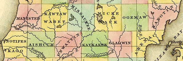
English: Detail of A New Map of Michigan With Its Canals, Roads & Distances by H.S. Tanner, 1842, showing:
|
|||||||||||||||||||
| تاریخ | 1842, ©1841 | |||||||||||||||||||
| ماخذ | File:1842 A new map of Michigan with its canals roads distances by H.S. Tanner.jpg | |||||||||||||||||||
| مصنف |
|
|||||||||||||||||||
| دوسرے نسخے | File:1842 A new map of Michigan with its canals roads distances by H.S. Tanner.jpg | |||||||||||||||||||
اجازہ کاری
This media file is in the public domain in the United States. This applies to U.S. works where the copyright has expired, often because its first publication occurred prior to January 1, 1929, and if not then due to lack of notice or renewal. See this page for further explanation.
|
 | |
 |
This image might not be in the public domain outside of the United States; this especially applies in the countries and areas that do not apply the rule of the shorter term for US works, such as Canada, Mainland China (not Hong Kong or Macao), Germany, Mexico, and Switzerland. The creator and year of publication are essential information and must be provided. See Wikipedia:Public domain and Wikipedia:Copyrights for more details.
|
فائل کا تاریخچہ
کسی خاص وقت یا تاریخ میں یہ فائل کیسی نظر آتی تھی، اسے دیکھنے کے لیے اس وقت/تاریخ پر کلک کریں۔
| تاریخ/وقت | تھمب نیل | ابعاد | صارف | تبصرہ | |
|---|---|---|---|---|---|
| رائج الوقت | 19:43، 5 اکتوبر 2016ء | 1,537 × 512 (861 کلوبائٹ) | TimK MSI | {{Information |Description ={{en|1=Detail of A New Map of Michigan With Its Canals, Roads & Distances by H.S. Tanner, 1842 showing: *[[w:Manistee County, Michiga... |
روابط
درج ذیل صفحہ اس فائل کو استعمال کر رہا ہے:
فائل کا عالمی استعمال
مندرجہ ذیل ویکیوں میں یہ فائل زیر استعمال ہے:
- ceb.wikipedia.org پر استعمال
- en.wikipedia.org پر استعمال
- ko.wikipedia.org پر استعمال
- www.wikidata.org پر استعمال