
فائل:Ain al-Assad air base, 8 jan 2020.png

اس نمائش کا حجم: 800 × 453 پکسلز۔ دیگر تصمیمات: 320 × 181 پکسلز | 640 × 362 پکسلز | 1,024 × 580 پکسلز | 1,280 × 724 پکسلز | 2,000 × 1,132 پکسلز۔
اصل فائل (2,000 × 1,132 پکسل، فائل کا حجم: 4.5 MB، MIME قسم: image/png)
خلاصہ
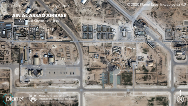
| تفصیل | Satellite image, showing the damage to at least five structures at Ain al-Assad air base in Iraq in a series of precision missile strikes launched by Iran |
| تاریخ | |
| ماخذ |
First upload: Brumfiel, Geoff; Welna, David (8 January 2020). Satellite Photos Reveal Extent Of Damage From Iranian Strike On Air Base In Iraq. NPR. Current upload: Garger, Kenneth (8 January 2020). Before-and-after satellite images show damage to Iraqi base hit by Iran. New York Post. |
| مصنف | Planet Labs, Inc. / Middlebury Institute of International Studies at Monterey |
| اجازت (فائل کا دوبارہ استعمال) |
There is a copyright notice in the upper right of this image. "© 2020 Planet Labs, Inc. cc-by-sa 4.0" |
اجازہ کاری
This file is licensed under the Creative Commons Attribution-Share Alike 4.0 International license.
لگاؤ: Planet Labs, Inc.
- آپ آزاد ہیں:
- شیئر کرنے – کام کو نقل، تقسیم یا منتقل کرنے کے لیے
- ریمکس کے لیے – کام منبطق کرنے کے لیے
- مندرجہ ذیل شرائط کے تحت:
- انتساب – آپ کو اس کام کا انتساب مصنف یا اجازت دہندہ کے بتائے گئے طریقہ کے مطابق دینا ہوگا (تاہم یہ انتساب اس طرح نہیں ہونا چاہیے کہ اسے دیکھ کر ایسا محسوس ہو کہ اصل مصنف یا اجازت دہندہ آپ کے یا آپ کے ذریعہ اس کام کے استعمال کرنے کے حامی ہیں)۔
- یکساں شراکت – اگر آپ اس کام میں کوئی تبدیلی یا ترمیم کرتے ہیں یا اس کام پر مبنی کچھ نیا بناتے ہیں تو اسے بھی آپ اسی یا اس جیسے کسی اجازت نامے کے تحت شائع کر سکتے ہیں۔
فائل کا تاریخچہ
کسی خاص وقت یا تاریخ میں یہ فائل کیسی نظر آتی تھی، اسے دیکھنے کے لیے اس وقت/تاریخ پر کلک کریں۔
| تاریخ/وقت | تھمب نیل | ابعاد | صارف | تبصرہ | |
|---|---|---|---|---|---|
| رائج الوقت | 06:14، 9 جنوری 2020ء | | 2,000 × 1,132 (4.5 MB) | EnchanterTim | Higher resolution from: https://nypost.com/2020/01/08/before-and-after-satellite-images-show-damage-to-iraqi-base-hit-by-iran/ |
| 19:52، 8 جنوری 2020ء |  | 800 × 449 (805 کلوبائٹ) | Cold Season | {{Information |Description= Satellite image, showing the damage to at least five hangars and buildings at Ain al-Assad air base in Iraq in a series of precision missile strikes launched by Iran |Source= [https://www.npr.org/2020/01/08/794517031/satellite-photos-reveal-extent-of-damage-at-al-assad-air-base?t=1578512699906 Satellite Photos Reveal Extent Of Damage From Iranian Strike On Air Base In Iraq]. NPR. |Date= 8 January 2020 |Author= Planet Labs Inc./Middlebury Institute |Permission= |ot... |
روابط
درج ذیل 2 صفحات اس فائل کو استعمال کر رہے ہیں:
فائل کا عالمی استعمال
مندرجہ ذیل ویکیوں میں یہ فائل زیر استعمال ہے:
- ar.wikipedia.org پر استعمال
- be.wikipedia.org پر استعمال
- ca.wikipedia.org پر استعمال
- ckb.wikipedia.org پر استعمال
- en.wikipedia.org پر استعمال
- es.wikipedia.org پر استعمال
- fa.wikipedia.org پر استعمال
- fi.wikipedia.org پر استعمال
- fr.wikipedia.org پر استعمال
- he.wikipedia.org پر استعمال
- id.wikipedia.org پر استعمال
- ja.wikipedia.org پر استعمال
- ka.wikipedia.org پر استعمال
- ko.wikipedia.org پر استعمال
- nl.wikipedia.org پر استعمال
- nl.wikinews.org پر استعمال
- pnb.wikipedia.org پر استعمال
- pt.wikipedia.org پر استعمال
- ru.wikipedia.org پر استعمال
- ru.wikinews.org پر استعمال
- so.wikipedia.org پر استعمال
- uk.wikipedia.org پر استعمال
- vi.wikipedia.org پر استعمال
- www.wikidata.org پر استعمال
- zh.wikipedia.org پر استعمال