
فائل:Anderson Manor - geograph.org.uk - 608301.jpg
اس سے زیادہ ریزولیوشن دستیاب نہیں۔
Anderson_Manor_-_geograph.org.uk_-_608301.jpg (640 × 426 پکسل، فائل کا حجم: 197 کلوبائٹ، MIME قسم: image/jpeg)
خلاصہ
| تفصیل |
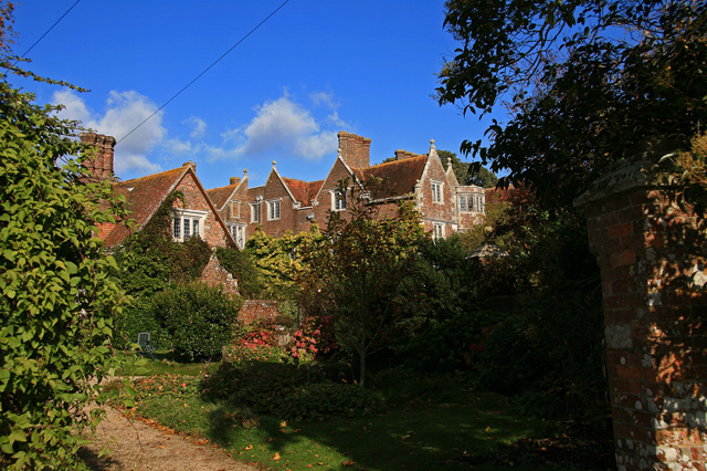
English: Anderson Manor Anderson Manor was built in 1622 for John Tregonwell, and was described three years later in Coker's Survey of Dorsetshire, as a 'faire newe house'. In more recent times it was taken over by the War Dept. during the Second World War, and became the headquarters for the Small Scale Raiding Force of 62 Commando. After the SSRF disbanded in 1943, Anderson Manor ended its wartime role as Station 62 under the Special Operations Executive (S.O.E.). The house is Grade I Listed.
|
|
| تاریخ | ||
| ماخذ | From geograph.org.uk | |
| مصنف | Mike Searle | |
| لگاؤ (required by the license) | Mike Searle / Anderson Manor / | |
| Camera location | | View this and other nearby images on: OpenStreetMap |
|---|
_heading:22.00&language=ur)
| Object location | | View this and other nearby images on: OpenStreetMap |
|---|
_heading:22.00&language=ur)
اجازہ کاری

|
This image was taken from the Geograph project collection. See this photograph's page on the Geograph website for the photographer's contact details. The copyright on this image is owned by Mike Searle and is licensed for reuse under the Creative Commons Attribution-ShareAlike 2.0 license.
|
This file is licensed under the Creative Commons Attribution-Share Alike 2.0 Generic license.
لگاؤ: Mike Searle
- آپ آزاد ہیں:
- شیئر کرنے – کام کو نقل، تقسیم یا منتقل کرنے کے لیے
- ریمکس کے لیے – کام منبطق کرنے کے لیے
- مندرجہ ذیل شرائط کے تحت:
- انتساب – آپ کو اس کام کا انتساب مصنف یا اجازت دہندہ کے بتائے گئے طریقہ کے مطابق دینا ہوگا (تاہم یہ انتساب اس طرح نہیں ہونا چاہیے کہ اسے دیکھ کر ایسا محسوس ہو کہ اصل مصنف یا اجازت دہندہ آپ کے یا آپ کے ذریعہ اس کام کے استعمال کرنے کے حامی ہیں)۔
- یکساں شراکت – اگر آپ اس کام میں کوئی تبدیلی یا ترمیم کرتے ہیں یا اس کام پر مبنی کچھ نیا بناتے ہیں تو اسے بھی آپ اسی یا اس جیسے کسی اجازت نامے کے تحت شائع کر سکتے ہیں۔
فائل کا تاریخچہ
کسی خاص وقت یا تاریخ میں یہ فائل کیسی نظر آتی تھی، اسے دیکھنے کے لیے اس وقت/تاریخ پر کلک کریں۔
| تاریخ/وقت | تھمب نیل | ابعاد | صارف | تبصرہ | |
|---|---|---|---|---|---|
| رائج الوقت | 22:22، 6 فروری 2011ء | | 640 × 426 (197 کلوبائٹ) | GeographBot | == {{int:filedesc}} == {{Information |description={{en|1=Anderson Manor Anderson Manor was built in 1622 for John Tregonwell, and was described three years later in Coker's Survey of Dorsetshire, as a 'faire newe house'. In more recent times it was taken |
روابط
درج ذیل صفحہ اس فائل کو استعمال کر رہا ہے:
فائل کا عالمی استعمال
مندرجہ ذیل ویکیوں میں یہ فائل زیر استعمال ہے:
- ceb.wikipedia.org پر استعمال
- cy.wikipedia.org پر استعمال
- dag.wikipedia.org پر استعمال
- da.wikipedia.org پر استعمال
- en.wikipedia.org پر استعمال
- fr.wikipedia.org پر استعمال
- it.wikipedia.org پر استعمال
- nl.wikipedia.org پر استعمال
- pl.wikipedia.org پر استعمال
- www.wikidata.org پر استعمال
- zh-min-nan.wikipedia.org پر استعمال