
فائل:Blois Loire Panorama - July 2011.jpg

اس نمائش کا حجم: 800 × 274 پکسلز۔ دیگر تصمیمات: 320 × 109 پکسلز | 640 × 219 پکسلز | 1,024 × 350 پکسلز | 1,280 × 438 پکسلز | 2,560 × 876 پکسلز | 12,000 × 4,105 پکسلز۔
اصل فائل (12,000 × 4,105 پکسل، فائل کا حجم: 14.95 MB، MIME قسم: image/jpeg)
|
خلاصہ
| تفصیل |
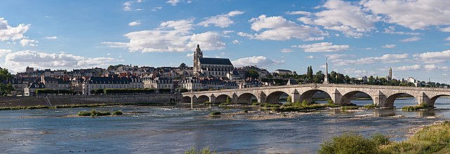
English: A 28 segment (2 x 14) panoramic view of Blois as viewed from the south-east on the far side of the Loire River.
Français : Vue panoramique de Blois (Loir-et-Cher, France), avec notamment le pont Jacques-Gabriel sur la Loire, la cathédrale Saint-Louis, et tout à droite le clocher de la basilique Notre-Dame de la Trinité |
| تاریخ | |
| ماخذ | ذاتی کام |
| مصنف | Diliff |
| اجازت (فائل کا دوبارہ استعمال) |
Summary:In using this image or any subsequent derivatives of it, you are required to release the image under the same license. As such, any reproduction of this image, in any medium, must appear with a copy of, or full URL of the license.Attribution of this image to the author (DAVID ILIFF) is also required, preferably in a prominent location near the image.No other conditions may be added to, or removed from this license without the permission of the author and copyright holder.Suggested attribution: "Photo by DAVID ILIFF. License: CC BY-SA 3.0"Please review the full license requirements carefully before using this image. If you would like to clarify the terms of the license or negotiate less restrictive commercial licensing outside of the bounds of GFDL/CC-BY-SA, please contact me by email, or if you don't have a Wikipedia account you can either leave a message on my talk page with your contact details and your request, or you can contact me on Facebook. Please also send a 'friend request' to ensure that I am aware of your message. |
| Camera location | | View this and other nearby images on: OpenStreetMap |
|---|

|
NOTE: This image is a panorama consisting of multiple frames that were merged or stitched in software. As a result, this image necessarily underwent some form of digital manipulation. These manipulations may include blending, blurring, cloning, and colour and perspective adjustments. As a result of these adjustments, the image content may be slightly different from reality at the points where multiple images were combined. This manipulation is often required due to lens, perspective, and parallax distortions.
|
This image has been assessed using the Quality image guidelines and is considered a Quality image.
|
اجازہ کاری
میں اس کام کا کاپی رائٹ ہولڈر ہوں اور اسے مندرجہ ذیل اجازت ناموں کے تحت شائع کیا ہے:
اس ملف کا لائسنس Creative Commons Attribution-Share Alike 3.0 Unported کے تحط ہے۔
- آپ آزاد ہیں:
- شیئر کرنے – کام کو نقل، تقسیم یا منتقل کرنے کے لیے
- ریمکس کے لیے – کام منبطق کرنے کے لیے
- مندرجہ ذیل شرائط کے تحت:
- انتساب – آپ کو اس کام کا انتساب مصنف یا اجازت دہندہ کے بتائے گئے طریقہ کے مطابق دینا ہوگا (تاہم یہ انتساب اس طرح نہیں ہونا چاہیے کہ اسے دیکھ کر ایسا محسوس ہو کہ اصل مصنف یا اجازت دہندہ آپ کے یا آپ کے ذریعہ اس کام کے استعمال کرنے کے حامی ہیں)۔
- یکساں شراکت – اگر آپ اس کام میں کوئی تبدیلی یا ترمیم کرتے ہیں یا اس کام پر مبنی کچھ نیا بناتے ہیں تو اسے بھی آپ اسی یا اس جیسے کسی اجازت نامے کے تحت شائع کر سکتے ہیں۔

|
آپ کو آزاد سافٹ ویئر فاؤنڈیشن کی جانب سے شائع کردہ جی این یو آزاد مسوداتی اجازت نامہ کی شرائط استعمال کے تحت اس دستاویز کو نقل، تقسیم اور/ یا ترمیم کرنے کی اجازت دی جاتی ہے۔ اس اجازت نامہ کی ایک نقل 'جی این یو آزاد مسوداتی اجازت نامہ کے عنوان سے میسر ہے۔ |
آپ حسب منشا اجازت نامہ منتخب کر سکتے ہیں۔
فائل کا تاریخچہ
کسی خاص وقت یا تاریخ میں یہ فائل کیسی نظر آتی تھی، اسے دیکھنے کے لیے اس وقت/تاریخ پر کلک کریں۔
| تاریخ/وقت | تھمب نیل | ابعاد | صارف | تبصرہ | |
|---|---|---|---|---|---|
| رائج الوقت | 20:31، 14 اگست 2011ء | 12,000 × 4,105 (14.95 MB) | Gzzz | Deletion of cloned men on the bridge (Modification asked by Tomer T) | |
| 11:07، 4 اگست 2011ء | 12,000 × 4,105 (14.94 MB) | Diliff | {{Information |Description ={{en|1=A 28 segment (2 x 14) panoramic view of Blois as viewed from the south-east on the far side of the Loire River.}} |Source ={{own}} |Author =Diliff |Date =2011-07-10 |Permissio |
روابط
درج ذیل 2 صفحات اس فائل کو استعمال کر رہے ہیں:
فائل کا عالمی استعمال
مندرجہ ذیل ویکیوں میں یہ فائل زیر استعمال ہے:
- an.wikipedia.org پر استعمال
- ar.wikipedia.org پر استعمال
- arz.wikipedia.org پر استعمال
- azb.wikipedia.org پر استعمال
- bm.wikipedia.org پر استعمال
- br.wikipedia.org پر استعمال
- cs.wikipedia.org پر استعمال
- de.wikivoyage.org پر استعمال
- el.wikipedia.org پر استعمال
- en.wikipedia.org پر استعمال
- Blois
- Portal:Geography
- Portal:Geography/Featured picture
- User:Diliff
- Wikipedia:Featured pictures/Places/Panorama
- User:Tomer T
- User talk:Tomer T/Archive 1
- Talk:Blois
- Wikipedia:Featured pictures thumbs/28
- Wikipedia:Featured picture candidates/August-2011
- Wikipedia:Featured picture candidates/Blois panorama
- Wikipedia:Wikipedia Signpost/2011-08-29/Featured content
- User talk:Diliff/Archive9
- Wikipedia:Picture of the day/January 2013
- Template:POTD/2013-01-14
- Wikipedia:Main Page history/2013 January 14
- Portal:Geography/Featured picture/23
- User talk:Diliff/Archive10
- Wikipedia:Wikipedia Signpost/Single/2011-08-29
- Jacques-Gabriel Bridge
- eo.wikipedia.org پر استعمال
- es.wikipedia.org پر استعمال
- fa.wikipedia.org پر استعمال
- fi.wikipedia.org پر استعمال
- fr.wikipedia.org پر استعمال
- fr.wikivoyage.org پر استعمال
اس فائل کا مزید عالمی استعمال دیکھیے۔