
فائل:Columbus Loup River Bridge from NW 1.JPG

اس نمائش کا حجم: 800 × 600 پکسلز۔ دیگر تصمیمات: 320 × 240 پکسلز | 640 × 480 پکسلز | 1,024 × 768 پکسلز | 1,280 × 960 پکسلز | 2,560 × 1,920 پکسلز۔
اصل فائل (2,560 × 1,920 پکسل، فائل کا حجم: 1.86 MB، MIME قسم: image/jpeg)
|
This is an image of a place or building that is listed on the National Register of Historic Places in the United States of America. Its reference number is 92000735. |
خلاصہ
| تفصیل |
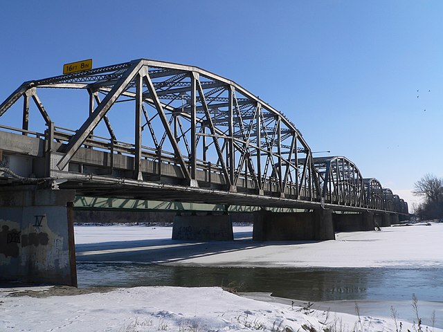
English: Columbus Loup River Bridge, carrying U.S. Highway 81 across the Loup River at the southern edge of Columbus, Nebraska; seen from the northwest (upstream). The Parker through truss bridge consists of seven trussed spans and two approach spans. It was built in 1932, and is listed in the National Register of Historic Places. The bridge currently carries two lanes of southbound traffic across the river; a bridge of more recent date carries two northbound lanes. The right pier in the middle of the photo belongs to the 1932 bridge; the left pier, to the later bridge. |
| تاریخ | |
| ماخذ | ذاتی کام |
| مصنف | Ammodramus |
| Object location | | View this and other nearby images on: OpenStreetMap |
|---|
اجازہ کاری
| میں اس تخلیقی کام کے حقوق کا مالک ہوں اور اسے دائرہ عام میں شائع کرتا ہوں جس کا اطلاق عالمی سطح پر ہوتا ہے۔ بعض ملکوں میں یہ قانونی طور پر شاید ممکن نہ ہو؛ اگر ایسا ہے تو: میں ہر ایک کو کسی بھی مقصد کے لیے بغیر کسی شرط کے اس تصویر کے استعمال کا حق تفویض کرتا/کرتی ہوں، بجز اس صورت کے جس میں کوئی قانونی رکاوٹ موجود ہو۔ |
فائل کا تاریخچہ
کسی خاص وقت یا تاریخ میں یہ فائل کیسی نظر آتی تھی، اسے دیکھنے کے لیے اس وقت/تاریخ پر کلک کریں۔
| تاریخ/وقت | تھمب نیل | ابعاد | صارف | تبصرہ | |
|---|---|---|---|---|---|
| رائج الوقت | 15:49، 13 فروری 2010ء | | 2,560 × 1,920 (1.86 MB) | Ammodramus | {{Information |Description={{en|1={{w|Columbus Loup River Bridge}}, carrying U.S. Highway 81 across the {{w|Loup River}} at the southern edge of {{w|Columbus, Nebraska}}; seen from the northwest (upstream). The [[:w:Truss bridge|Park |
روابط
درج ذیل صفحہ اس فائل کو استعمال کر رہا ہے:
فائل کا عالمی استعمال
مندرجہ ذیل ویکیوں میں یہ فائل زیر استعمال ہے:
- af.wikipedia.org پر استعمال
- azb.wikipedia.org پر استعمال
- ceb.wikipedia.org پر استعمال
- de.wikipedia.org پر استعمال
- en.wikipedia.org پر استعمال
- es.wikipedia.org پر استعمال
- fa.wikipedia.org پر استعمال
- ja.wikipedia.org پر استعمال
- ru.wikipedia.org پر استعمال
- simple.wikipedia.org پر استعمال
- sr.wikipedia.org پر استعمال
- tr.wikipedia.org پر استعمال
- uk.wikipedia.org پر استعمال
- zh-min-nan.wikipedia.org پر استعمال
- zh.wikipedia.org پر استعمال