
فائل:Conquest mexico 1519 21.png

اس نمائش کا حجم: 800 × 399 پکسلز۔ دیگر تصمیمات: 320 × 160 پکسلز | 640 × 320 پکسلز | 1,300 × 649 پکسلز۔
اصل فائل (1,300 × 649 پکسل، فائل کا حجم: 1.45 MB، MIME قسم: image/png)
خلاصہ

|
This file has been superseded by Ruta de Cortés.svg. It is recommended to use the other file. Please note that deleting superseded images requires consent. Reason to use the other file: "The source of that other map is more recent and reliable."
|
| تفصیل |
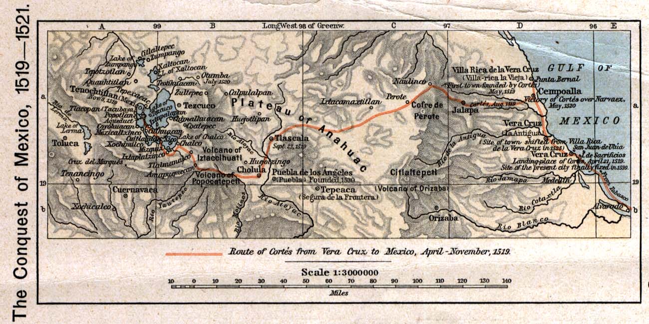
English: The 1519 to 1521 route of the Spanish conquest of the Aztec Empire — taken in Central Mexico by Hernando Cortés.
Français : La route de la conquête espagnole de l'Empire aztèque au centre de Mexique, comme suivi par Hernán Cortés de 1519 à 1521 |
| تاریخ | |
| ماخذ |
English: Scan from Historical Atlas by William R. Shepherd, New York, Henry Holt and Company, 1926 ed. Original image at the Perry-Castañeda Library Map Collection at the en:University of Texas at Austin website: http://www.lib.utexas.edu/maps/historical/shepherd/conquest_mexico_1519_21.jpg |
| مصنف | William R. Shepherd |
| اجازت (فائل کا دوبارہ استعمال) |
English: From the FAQ @ http://www.lib.utexas.edu/maps/faq.html
|
| دوسرے نسخے |
|

اجازہ کاری
This file may not have the correct information on its copyright status.
Notify the uploader with:
Items tagged with this template are sorted into Category:Items with disputed copyright information.
|
This media file is in the public domain in the United States. This applies to U.S. works where the copyright has expired, often because its first publication occurred prior to January 1, 1929, and if not then due to lack of notice or renewal. See this page for further explanation.
|
 | |
 |
This image might not be in the public domain outside of the United States; this especially applies in the countries and areas that do not apply the rule of the shorter term for US works, such as Canada, Mainland China (not Hong Kong or Macao), Germany, Mexico, and Switzerland. The creator and year of publication are essential information and must be provided. See Wikipedia:Public domain and Wikipedia:Copyrights for more details.
|
اولین اپلوڈ کا نوشتہ
فائل کی تفصیلات کا اصل صفحہ یہاں تھا۔ درج ذیل تمام صارفین en.wikipedia کے ہیں۔
- 2006-12-18 21:20 Jengod 1300×649×8 (1520705 bytes) Scan from "Historical Atlas" by William R. Shepherd, New York, Henry Holt and Company, 1926 ed. Original image at the [http://www.lib.utexas.edu/maps/ Perry-Castañeda Library Map Collection] at the [[University of Texas at Austin]] website: http://www.l
فائل کا تاریخچہ
کسی خاص وقت یا تاریخ میں یہ فائل کیسی نظر آتی تھی، اسے دیکھنے کے لیے اس وقت/تاریخ پر کلک کریں۔
| تاریخ/وقت | تھمب نیل | ابعاد | صارف | تبصرہ | |
|---|---|---|---|---|---|
| رائج الوقت | 20:12، 17 اپریل 2008ء | | 1,300 × 649 (1.45 MB) | File Upload Bot (Magnus Manske) | {{BotMoveToCommons|en.wikipedia}} {{Information |Description={{en|Scan from "Historical Atlas" by William R. Shepherd, New York, Henry Holt and Company, 1926 ed. Original image at the [http://www.lib.utexas.edu/maps/ Perry-Castañeda Library Map Collect |
روابط
درج ذیل صفحہ اس فائل کو استعمال کر رہا ہے:
فائل کا عالمی استعمال
مندرجہ ذیل ویکیوں میں یہ فائل زیر استعمال ہے:
- azb.wikipedia.org پر استعمال
- ca.wikipedia.org پر استعمال
- cs.wikipedia.org پر استعمال
- en.wikipedia.org پر استعمال
- es.wikipedia.org پر استعمال
- fa.wikipedia.org پر استعمال
- ja.wikipedia.org پر استعمال
- ms.wikipedia.org پر استعمال
- pnb.wikipedia.org پر استعمال
- sl.wikipedia.org پر استعمال
- th.wikipedia.org پر استعمال
- tr.wikipedia.org پر استعمال
- uk.wikipedia.org پر استعمال
- vi.wikipedia.org پر استعمال
- www.wikidata.org پر استعمال