
فائل:Districts of Khyber Pakhtunkhwa, Pakistan.png

اس نمائش کا حجم: 600 × 600 پکسلز۔ دیگر تصمیمات: 240 × 240 پکسلز | 480 × 480 پکسلز | 768 × 768 پکسلز | 1,024 × 1,024 پکسلز | 2,048 × 2,048 پکسلز | 3,840 × 3,840 پکسلز۔
اصل فائل (3,840 × 3,840 پکسل، فائل کا حجم: 1.45 MB، MIME قسم: image/png)
This file supersedes the file Khyber Pakhtunkhwa, KPK, Map.png. It is recommended to use this file rather than the other one. Reason why to use this file over the other file: "More up-to-date map and fixed borders."
|

|
خلاصہ
| تفصیل |
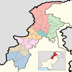
English: This is a map showing each and every district of Khyber Pakhtunkhwa. The map is accurate as of September 30, 2020 and has been made using data from the Pakistan Bureau of Statistics and UN OCHA's HumData Database (which citypopulation.de uses). Each color depicts a different administrative division (higher than a district but lower than a province).
A category full of these maps listed nicely can be found here. |
| تاریخ | |
| ماخذ | ذاتی کام |
| مصنف | User:Abbasi786786 |
اجازہ کاری
میں اس تخلیقی کام کے حقوق کا مالک ہوں اور اسے مندرجہ ذیل اجازت نامے کے تحت شائع کرتا ہوں:
This file is licensed under the Creative Commons Attribution-Share Alike 4.0 International license.
- آپ آزاد ہیں:
- شیئر کرنے – کام کو نقل، تقسیم یا منتقل کرنے کے لیے
- ریمکس کے لیے – کام منبطق کرنے کے لیے
- مندرجہ ذیل شرائط کے تحت:
- انتساب – آپ کو اس کام کا انتساب مصنف یا اجازت دہندہ کے بتائے گئے طریقہ کے مطابق دینا ہوگا (تاہم یہ انتساب اس طرح نہیں ہونا چاہیے کہ اسے دیکھ کر ایسا محسوس ہو کہ اصل مصنف یا اجازت دہندہ آپ کے یا آپ کے ذریعہ اس کام کے استعمال کرنے کے حامی ہیں)۔
- یکساں شراکت – اگر آپ اس کام میں کوئی تبدیلی یا ترمیم کرتے ہیں یا اس کام پر مبنی کچھ نیا بناتے ہیں تو اسے بھی آپ اسی یا اس جیسے کسی اجازت نامے کے تحت شائع کر سکتے ہیں۔
فائل کا تاریخچہ
کسی خاص وقت یا تاریخ میں یہ فائل کیسی نظر آتی تھی، اسے دیکھنے کے لیے اس وقت/تاریخ پر کلک کریں۔
| تاریخ/وقت | تھمب نیل | ابعاد | صارف | تبصرہ | |
|---|---|---|---|---|---|
| رائج الوقت | 14:42، 16 جون 2020ء | | 3,840 × 3,840 (1.45 MB) | Abbasi786786 | Added a box in the bottom right corner to signify where Khyber Pakhtunkhwa Province is in Pakistan. |
| 17:09، 15 جون 2020ء |  | 3,840 × 3,840 (1.31 MB) | Abbasi786786 | Uploaded own work with UploadWizard |
روابط
اس فائل سے مربوط کوئی صفحہ موجود نہیں ہے۔
فائل کا عالمی استعمال
مندرجہ ذیل ویکیوں میں یہ فائل زیر استعمال ہے:
- bn.wikipedia.org پر استعمال
- de.wikipedia.org پر استعمال
- en.wikipedia.org پر استعمال
- pnb.wikipedia.org پر استعمال
- sd.wikipedia.org پر استعمال