
فائل:East-Hem 1100ad.jpg

اصل فائل (3,240 × 1,903 پکسل، فائل کا حجم: 3.16 MB، MIME قسم: image/jpeg)

|
This historical map image could be re-created using vector graphics as an SVG file. This has several advantages; see Commons:Media for cleanup for more information. If an SVG form of this image is available, please upload it and afterwards replace this template with
{{vector version available|new image name}}.
It is recommended to name the SVG file “East-Hem 1100ad.svg”—then the template Vector version available (or Vva) does not need the new image name parameter. |


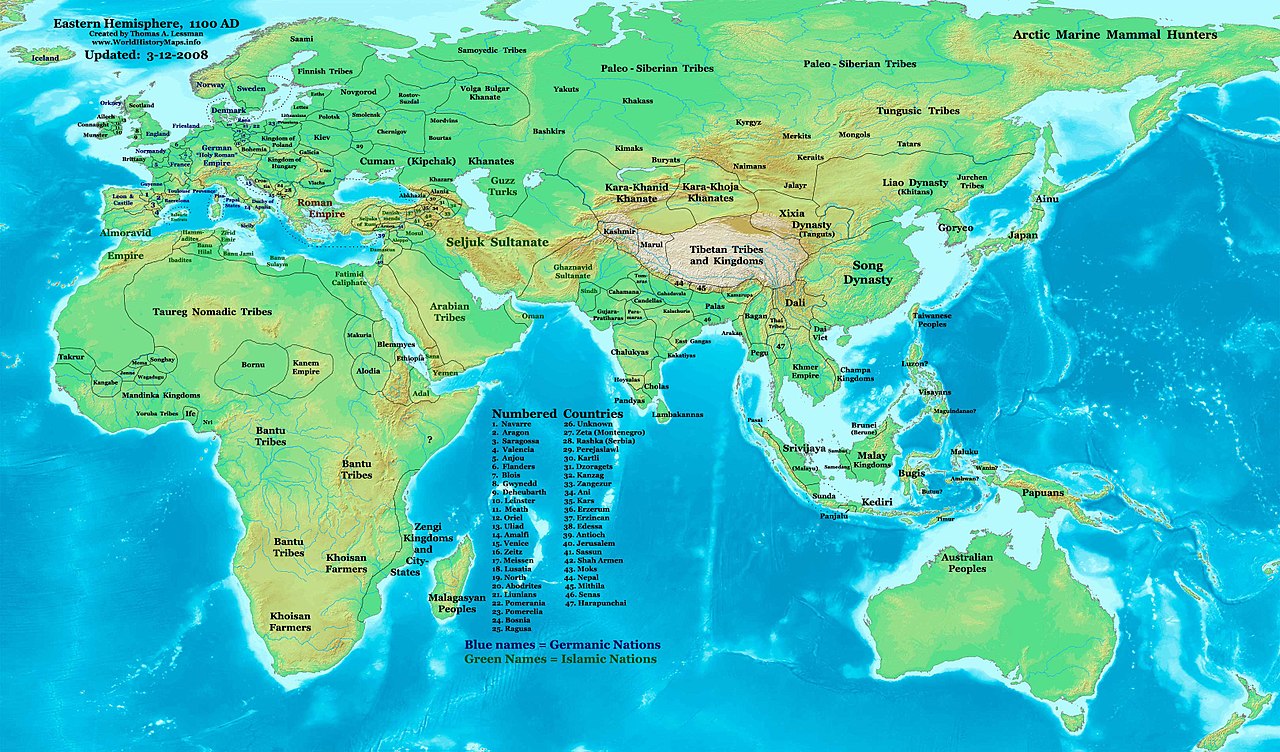
| تفصیل | Eastern Hemisphere in 1100 AD. |
| ماخذ | self-made (For reference information, see the Map Source References section below.) |
| مصنف | Thomas Lessman (Contact!) |
| اجازت (فائل کا دوبارہ استعمال) |
میں اس تخلیقی کام کے حقوق کا مالک ہوں اور اسے مندرجہ ذیل اجازت نامے کے تحت شائع کرتا ہوں: اس ملف کا لائسنس Creative Commons Attribution-Share Alike 3.0 Unported کے تحط ہے۔
|
| دوسرے نسخے | see East-Hem_1100ad.jpg file history on Wikipedia. |
Map Summary
Original Source URL: http://www.thomaslessman.com/History/images/East-Hem_1100ad.jpg.
This map of the Eastern Hemisphere in 1100 AD was created by Thomas Lessman, based on information from the sources listed below. This map is free for educational use (see Permission info above). When using this map, please mention that it is available for free at www.WorldHistoryMaps.info.
Keep in mind that sources often conflict with each other, and they are as accurate as the information that is available to me. To report any errors, or if you want to help further this work, please see here, or email Thomas Lessman at talessman@yis.us.
Map Source References
- Remember, sources often conflict with each other. This map is only as accurate as the information that is available to me. To report any errors or to help further this work, please click here, or email Thomas Lessman at talessman@yis.us
References for information contained in this map:
1. Borders of Europe are mostly derived from the www.Euratlas.com map of Europe in 1100 AD.
- (Please note: Bogomolov.PL has done a great job of showing me possible discrepancies in my north European borders compared to this source, due to the differences in the geographical layout of the maps.)
2. Borders of Asian countries derive from various Wikipedia articles and Google history map searches.
3. Much of the information in this map was cross-checked with Bruce Gordon's Regnal Chronologies.
Other Maps by Thomas Lessman
| Maps of the eastern hemisphere showing history
Bold dates are available on Wikimedia or Wikipedia. | ||
| Primeval | ||
| Ancient
|
·| 600 BC | 550 BC | 527 BC | 500 BC |
400 BC | ·| 1 AD | 50 AD | 100 AD | 200 AD | 300 AD | | |
| Medieval |
·| 500 AD | 565 AD | 600 AD | 700 AD | | |
| Modern |
·| 1500 AD | · * For historical maps of the whole world, | |
Other Info
فائل کا تاریخچہ
کسی خاص وقت یا تاریخ میں یہ فائل کیسی نظر آتی تھی، اسے دیکھنے کے لیے اس وقت/تاریخ پر کلک کریں۔
| تاریخ/وقت | تھمب نیل | ابعاد | صارف | تبصرہ | |
|---|---|---|---|---|---|
| رائج الوقت | 11:16، 16 جنوری 2009ء | | 3,240 × 1,903 (3.16 MB) | Ukabia | {{Information |Description= |Source= |Date= |Author= |Permission= |other_versions= }} |
| 20:46، 9 مئی 2008ء |  | 3,240 × 1,903 (782 کلوبائٹ) | Talessman | {{Information |Description=Eastern Hemisphere in 1100 AD. |Source=self-made |Author=Thomas Lessman |Permission={{self|cc-by-sa-3.0}} }} |
روابط
درج ذیل صفحہ اس فائل کو استعمال کر رہا ہے:
فائل کا عالمی استعمال
مندرجہ ذیل ویکیوں میں یہ فائل زیر استعمال ہے:
- arz.wikipedia.org پر استعمال
- azb.wikipedia.org پر استعمال
- be.wikipedia.org پر استعمال
- bs.wikipedia.org پر استعمال
- de.wikipedia.org پر استعمال
- de.wikiversity.org پر استعمال
- en.wikipedia.org پر استعمال
- es.wikipedia.org پر استعمال
- et.wikipedia.org پر استعمال
- fr.wikipedia.org پر استعمال
- gl.wikipedia.org پر استعمال
- hu.wikipedia.org پر استعمال
- mk.wikipedia.org پر استعمال
- mr.wikipedia.org پر استعمال
- my.wikipedia.org پر استعمال
- nn.wikipedia.org پر استعمال
- ro.wikipedia.org پر استعمال
- rue.wikipedia.org پر استعمال
- shn.wikipedia.org پر استعمال
- sh.wikipedia.org پر استعمال
- si.wikipedia.org پر استعمال
- sv.wikipedia.org پر استعمال
- sw.wikipedia.org پر استعمال
- ta.wikipedia.org پر استعمال
- tl.wikipedia.org پر استعمال
- uk.wikipedia.org پر استعمال
- vi.wikipedia.org پر استعمال