
فائل:East Branch Clarion River Lake at Elk State Park.jpg
اس نمائش کا حجم: 800 × 600 پکسلز۔ دیگر تصمیمات: 320 × 240 پکسلز | 640 × 480 پکسلز | 1,024 × 768 پکسلز | 1,280 × 960 پکسلز | 2,304 × 1,728 پکسلز۔
اصل فائل (2,304 × 1,728 پکسل، فائل کا حجم: 1.28 MB، MIME قسم: image/jpeg)
خلاصہ
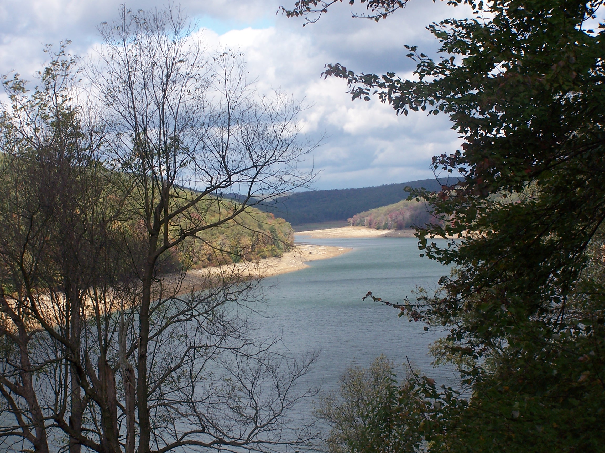
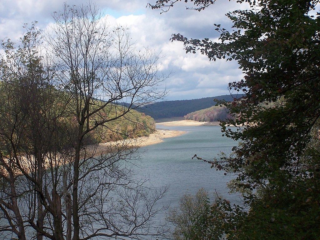
| تفصیل | The level of this reservoir varies widely in its function as a flood control for the Clarion & Allegheny Rivers. Under the water at just about the point it disappears around the bend is the town of Instanter. From the late 19th c until the 1920s, this area was nearly clearcut of hemlock - just to get the chemicals out of its bark. Location for this photo reached by driving twelve miles on unpaved roads and walking four miles more. Interestingly, when I located this on the Flickr map, it self identified as Instanter, which I did not know was still used as a geographical location. |
| تاریخ | |
| ماخذ | east branch reservoir elk county pa |
| مصنف | Tim Engleman |
اجازہ کاری
This file is licensed under the Creative Commons Attribution-Share Alike 2.0 Generic license.
- آپ آزاد ہیں:
- شیئر کرنے – کام کو نقل، تقسیم یا منتقل کرنے کے لیے
- ریمکس کے لیے – کام منبطق کرنے کے لیے
- مندرجہ ذیل شرائط کے تحت:
- انتساب – آپ کو اس کام کا انتساب مصنف یا اجازت دہندہ کے بتائے گئے طریقہ کے مطابق دینا ہوگا (تاہم یہ انتساب اس طرح نہیں ہونا چاہیے کہ اسے دیکھ کر ایسا محسوس ہو کہ اصل مصنف یا اجازت دہندہ آپ کے یا آپ کے ذریعہ اس کام کے استعمال کرنے کے حامی ہیں)۔
- یکساں شراکت – اگر آپ اس کام میں کوئی تبدیلی یا ترمیم کرتے ہیں یا اس کام پر مبنی کچھ نیا بناتے ہیں تو اسے بھی آپ اسی یا اس جیسے کسی اجازت نامے کے تحت شائع کر سکتے ہیں۔
| This image was originally posted to Flickr by shadysidelantern at https://www.flickr.com/photos/92934406@N00/1591200427. It was reviewed on 30 اکتوبر 2007 by FlickreviewR and was confirmed to be licensed under the terms of the cc-by-sa-2.0. |
فائل کا تاریخچہ
کسی خاص وقت یا تاریخ میں یہ فائل کیسی نظر آتی تھی، اسے دیکھنے کے لیے اس وقت/تاریخ پر کلک کریں۔
| تاریخ/وقت | تھمب نیل | ابعاد | صارف | تبصرہ | |
|---|---|---|---|---|---|
| رائج الوقت | 03:23، 29 مئی 2012ء | | 2,304 × 1,728 (1.28 MB) | Ruhrfisch | Original size version of current photo, all other information is the same |
| 22:03، 29 اکتوبر 2007ء |  | 500 × 375 (185 کلوبائٹ) | Gerry D | {{Information |Description= The level of this reservoir varies widely in its function as a flood control for the Clarion & Allegheny Rivers. Under the water at just about the point it disappears around the bend is the town of Instanter. From the late 19 |
روابط
درج ذیل صفحہ اس فائل کو استعمال کر رہا ہے:
فائل کا عالمی استعمال
مندرجہ ذیل ویکیوں میں یہ فائل زیر استعمال ہے:
- ceb.wikipedia.org پر استعمال
- cy.wikipedia.org پر استعمال
- en.wikipedia.org پر استعمال
- es.wikipedia.org پر استعمال
- fr.wikipedia.org پر استعمال
- uk.wikipedia.org پر استعمال
- vi.wikipedia.org پر استعمال
- www.wikidata.org پر استعمال