
فائل:Greater London in England (wo City of London) (zoom).svg

اس SVG فائل کی PNG نمائش کا حجم: 494 × 600 پکسلز دیگر تصمیمات: 198 × 240 پکسلز | 395 × 480 پکسلز | 632 × 768 پکسلز | 843 × 1,024 پکسلز | 1,686 × 2,048 پکسلز | 816 × 991 پکسلز۔
اصل فائل (ایس وی جی فائل، ابعاد 816 × 991 پکسل، فائل کا حجم: 1.32 MB)
خلاصہ
| تفصیل |
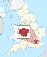
Deutsch: Lage der zeremoniellen Grafschaft XY (siehe Dateiname) inmitten der nicht-zeremoniellen Verwaltungsgliederung in England. (Rot markiert ist also das Gebiet einer zeremoniellen Grafschaft. Eingezeichnet sind also innerhalb Englands nur die Grenze der Regionen, der ländlichen Grafschaften, der städtischen Bezirke als Teilgebiete der städtischen Grafschaften, der Bezirke Londons, und der Gebiete der einstufigen Verwaltungen.)
English: Location of ceremonial county xy (see filename) within non-ceremonial administrative divisions in England. (Hence, within England, the maps shows only borders of regions, of non-metropolitan counties, of metropolitan boroughs (i.e. subdivisions of metropolitan counties), of the areas of unitary authorities and of the London boroughs.) |
||||
| تاریخ | |||||
| ماخذ |
ذاتی کام This W3C-unspecified vector image was created with Adobe Illustrator. This SVG file was uploaded with Commonist. This vector image includes elements that have been taken or adapted from this file: This vector image includes elements that have been taken or adapted from this file: |
||||
| مصنف |
TUBS |
||||
| دوسرے نسخے |
|
||||
.svg)
.svg)
.svg)
.svg)
.svg)
.svg)
.svg)

-en.svg)

.svg)
.svg)
.svg)

_(US48).svg)
_(small_islands_magnified)_(-mini_map_-rivers).svg)
.svg)
_(extra_close)_(US48).svg)
.svg)
_(zoom).svg)

.svg)


_(UNMIK).svg)
.svg)
_(disputed_hatched).svg)
_(claimed_and_disputed_hatched).svg)
.svg)
.svg)
_(%2Ball_claims_hatched).svg)

.svg)
_(shade).svg)
_(shade)_(special_marker).svg)
_(-mini_map).svg)
_(-mini_map).svg)
_(-mini_map).svg)


.svg)

.svg)
_(zoom).svg)
اجازہ کاری
میں اس تخلیقی کام کے حقوق کا مالک ہوں اور اسے مندرجہ ذیل اجازت نامے کے تحت شائع کرتا ہوں:
اس ملف کا لائسنس Creative Commons Attribution-Share Alike 3.0 Unported کے تحط ہے۔
- آپ آزاد ہیں:
- شیئر کرنے – کام کو نقل، تقسیم یا منتقل کرنے کے لیے
- ریمکس کے لیے – کام منبطق کرنے کے لیے
- مندرجہ ذیل شرائط کے تحت:
- انتساب – آپ کو اس کام کا انتساب مصنف یا اجازت دہندہ کے بتائے گئے طریقہ کے مطابق دینا ہوگا (تاہم یہ انتساب اس طرح نہیں ہونا چاہیے کہ اسے دیکھ کر ایسا محسوس ہو کہ اصل مصنف یا اجازت دہندہ آپ کے یا آپ کے ذریعہ اس کام کے استعمال کرنے کے حامی ہیں)۔
- یکساں شراکت – اگر آپ اس کام میں کوئی تبدیلی یا ترمیم کرتے ہیں یا اس کام پر مبنی کچھ نیا بناتے ہیں تو اسے بھی آپ اسی یا اس جیسے کسی اجازت نامے کے تحت شائع کر سکتے ہیں۔

|
I'd greatly appreciate, that you attribute this media file to Wikimedia Commons, if used outside Wikipedia or Commons. For use in publications such as books, newspapers, blogs, websites, please insert here the following line:
|
_(zoom).svg&action=edit&redlink=1)
فائل کا تاریخچہ
کسی خاص وقت یا تاریخ میں یہ فائل کیسی نظر آتی تھی، اسے دیکھنے کے لیے اس وقت/تاریخ پر کلک کریں۔
| تاریخ/وقت | تھمب نیل | ابعاد | صارف | تبصرہ | |
|---|---|---|---|---|---|
| رائج الوقت | 21:48، 28 نومبر 2011ء | | 816 × 991 (1.32 MB) | TUBS |
روابط
درج ذیل صفحہ اس فائل کو استعمال کر رہا ہے:
فائل کا عالمی استعمال
مندرجہ ذیل ویکیوں میں یہ فائل زیر استعمال ہے:
- az.wikipedia.org پر استعمال
- en.wikipedia.org پر استعمال
- fa.wikipedia.org پر استعمال
- he.wikipedia.org پر استعمال
- ja.wikipedia.org پر استعمال
- ko.wikipedia.org پر استعمال
- ms.wikipedia.org پر استعمال
- no.wikipedia.org پر استعمال
- pnb.wikipedia.org پر استعمال
- qu.wikipedia.org پر استعمال
- th.wikipedia.org پر استعمال
- tum.wikipedia.org پر استعمال
- uk.wikipedia.org پر استعمال
_(zoom).svg)