
فائل:ISS012-E-23598 NASA-Savai'i east end, Apolima strait, Upolu.jpg

اس نمائش کا حجم: 800 × 531 پکسلز۔ دیگر تصمیمات: 320 × 212 پکسلز | 640 × 424 پکسلز | 1,024 × 679 پکسلز | 1,280 × 849 پکسلز | 3,040 × 2,016 پکسلز۔
اصل فائل (3,040 × 2,016 پکسل، فائل کا حجم: 1.81 MB، MIME قسم: image/jpeg)
خلاصہ
| تفصیل |
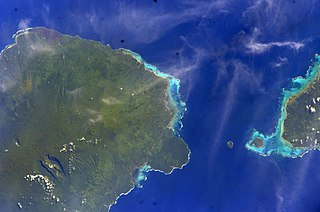
English: East side of Savai'i Island, Apolima, Manono & west end of Upolu |
| تاریخ | |
| ماخذ | Image Science and Analysis Laboratory, NASA-Johnson Space Center. "The Gateway to Astronaut Photography of Earth." <http://eol.jsc.nasa.gov/scripts/sseop/QuickView.pl?directory=ESC&ID=ISS012-E-23598> |
| مصنف | NASA |
| Camera location | | View this and other nearby images on: OpenStreetMap |
|---|
This image or video was catalogued by Johnson Space Center of the United States National Aeronautics and Space Administration (NASA) under Photo ID: ISS012-E-23598. This tag does not indicate the copyright status of the attached work. A normal copyright tag is still required. See Commons:Licensing. Other languages:
|
اجازہ کاری
This file is in the public domain in the United States because it was created by the Image Science & Analysis Laboratory, of the NASA Johnson Space Center. NASA copyright policy states that "NASA material is not protected by copyright unless noted". (NASA media use guidelines or Conditions of Use of Astronaut Photographs).
Photo source: ISS012-E-23598.
|
فائل کا تاریخچہ
کسی خاص وقت یا تاریخ میں یہ فائل کیسی نظر آتی تھی، اسے دیکھنے کے لیے اس وقت/تاریخ پر کلک کریں۔
| تاریخ/وقت | تھمب نیل | ابعاد | صارف | تبصرہ | |
|---|---|---|---|---|---|
| رائج الوقت | 13:41، 18 مئی 2013ء | | 3,040 × 2,016 (1.81 MB) | Ras67 | new rendered from NASA's raw image data |
| 03:14، 7 اگست 2012ء |  | 639 × 423 (88 کلوبائٹ) | Ras67 | rotated and cropped from NASA's original | |
| 13:43، 30 جنوری 2010ء |  | 639 × 435 (62 کلوبائٹ) | Teinesavaii | {{Information |Description={{en|1=East side of Savai'i Island, Apolima, Manono & west end of Upolu}} |Source=Image Science and Analysis Laboratory, NASA-Johnson Space Center. "The Gateway to Astronaut Photography of Earth." <http://eol.jsc.nasa.gov/scri |
روابط
درج ذیل 2 صفحات اس فائل کو استعمال کر رہے ہیں:
فائل کا عالمی استعمال
مندرجہ ذیل ویکیوں میں یہ فائل زیر استعمال ہے:
- bn.wikipedia.org پر استعمال
- ceb.wikipedia.org پر استعمال
- de.wikipedia.org پر استعمال
- en.wikipedia.org پر استعمال
- es.wikipedia.org پر استعمال
- eu.wikipedia.org پر استعمال
- id.wikipedia.org پر استعمال
- ka.wikipedia.org پر استعمال
- mk.wikipedia.org پر استعمال
- mrj.wikipedia.org پر استعمال
- no.wikipedia.org پر استعمال
- pl.wikipedia.org پر استعمال
- ru.wikipedia.org پر استعمال
- sk.wikipedia.org پر استعمال
- sm.wikipedia.org پر استعمال
- uk.wikipedia.org پر استعمال
- www.wikidata.org پر استعمال
- zh.wikipedia.org پر استعمال