
فائل:Jerusalem-2013(2)-Aerial-Temple Mount-(south exposure).jpg

اس نمائش کا حجم: 799 × 600 پکسلز۔ دیگر تصمیمات: 320 × 240 پکسلز | 639 × 480 پکسلز | 1,023 × 768 پکسلز | 1,280 × 961 پکسلز | 2,560 × 1,922 پکسلز | 7,500 × 5,632 پکسلز۔
اصل فائل (7,500 × 5,632 پکسل، فائل کا حجم: 40.97 MB، MIME قسم: image/jpeg)
خلاصہ
| تفصیل |
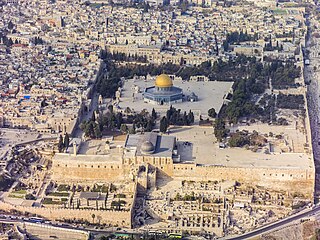
العربية: لقطة جويَّة جنوبيَّة للحرم القدسي الشريف، الواقع في بلدة القدس القديمة. يظهرُ في المُقدِّمة المسجد القبلي الذي يُخطئ الكثير من النَّاس ويعتقدون أنَّه المسجد الأقصى، ثالثُ أقدس الأماكن في الإسلام بعد المسجد الحرام والمسجد النبوي، في حين أنَّ هذا المُجمَّع بأكمله هو المسجد الأقصى. تظهرُ في الخلف قبَّة الصخرة وإلى يمينها قبَّة السلسلة، التي شُيِّدت خلال العهد الأُمويّ (حوالي سنة 685 للميلاد) واتُخذت نموذجًا لبناء قبَّة الصخرة (حوالي سنة. 691 للميلاد). يعتبرُ اليهود أنَّ هيكل سُليمان، وهو أقدسُ الأماكن في اليهوديَّة يقعُ أسفل المسجد الأقصى.
English: Southern aerial view of the Temple Mount (Hebrew: הַר הַבַּיִת, Har HaBáyit, Arabic: الحرم الشريف, al-Ḥaram al-Šarīf), showing, Al-Aqsa Mosque (Hebrew: הַר הַבַּיִת, Arabic: المسجد الأقصى المبارك) in the Old City of Jerusalem (Hebrew: העיר העתיקה, Arabic: البلدة القديمة). Annotated in the foreground is Al-Aqsa Mosque (Arabic: ٱلْمَسْجِد ٱلْأَقْصَى). Al-Aqsa Mosque is considered to be the third holiest site in Islam after Mecca and Medina. Behind are The Dome of the Rock (Hebrew: כיפת הסלע, Arabic: مسجد قبة الصخرة) and to the right, The Dome of the Chain (Arabic: قبة السلسلة, Qubbat al-Silsila), constructed during the Umayyad Caliphate (c. 685 AD) and served as a model for the building of the Dome of the Rock (c. 691 AD). The Temple Mount, which is called by Muslims Al-Aqsa Mosque, is considered to be the premier holy site in Judaism as it is the place where the first and second Temples stood.
עברית: מבט מדרום על הר הבית בעיר העתיקה בירושלים. בחזית רואים את מסגד אל-אקצה, שנחשב לשלישי בדרגת הקדושה באיסלם, אחרי מכה ומדינה. מאחור כיפת הסלע ומימין כיפת השלשלת, שנבנתה בתקופת חליפות אומיה ושימשה כמודל לבניית כיפת הסלע. הר הבית, עליו נבנה מסגד אל-אקצה נחשב למקום הקדוש ביותר ביהדות, כיוון שעליו נצבו בית המקדש הראשון והשני.
|
| تاریخ | |
| ماخذ | ذاتی کام |
| مصنف | Godot13 |
| دوسرے نسخے | |
| لگاؤ (required by the license) | Andrew Shiva / Wikipedia / |
.jpg)
.jpg)
.jpg)
.jpg)
.jpg)
.jpg)
,_2013_aerial_from_S_(cropped).jpg)
.jpg)
.jpg)
.jpg)
.jpg)
-Aerial-Temple_Mount-(south_exposure).jpg)
Türkçe: Tapınak Dağı'nın (İbranice: הַר הַבַּיִת, Har HaBáyit, Arapça: الحرم الشريف, al-Ḥaram al-Šarīf) güneyden havadan görünümü, Mescid-i Aksa'yı (İbranice: הַר הַבַּיִת, Arapça: المسجد الأقصى المبارك), Kudüs'ün Eski Şehri'nde (İbranice: העיר העתיקה, Arapça: البلدة القديمة). Ön planda El-Aksa Camii (Arapça: ٱلْمَسْجِد ٱلْأَقْصَى) gösterilmektedir. Mescid-i Aksa, Mekke ve Medine'den sonra İslam'ın en kutsal üçüncü mekânı olarak kabul edilir. Arkada Kubbet-üs Sahra (İbranice: כיפת הסלע, Arapça: مسجد قبة الصخرة) ve sağda Kubbet-üs Sahra (Arapça: قبة السلسلة, Qubbat al-Silsila), Emevi Halifeliği döneminde (yaklaşık MS 685) ve Kubbetü's-Sahra'nın (MS 691) inşası için bir model olarak hizmet etmiştir. Müslümanlar tarafından Mescid-i Aksa olarak adlandırılan Tapınak Dağı, birinci ve ikinci Tapınakların bulunduğu yer olması nedeniyle Yahudilikte en önemli kutsal alan olarak kabul edilmektedir.
| Camera location | | View this and other nearby images on: OpenStreetMap |
|---|
-Aerial-Temple_Mount-(south_exposure).jpg¶ms=031.772558_N_0035.238153_E_globe:Earth_type:camera_heading:337.50&language=ur)
Assessment
|
-Aerial-Jerusalem-Temple_Mount-Temple_Mount_(south_exposure).jpg)
-Aerial-Temple_Mount-(south_exposure).jpg)
-Aerial-Temple_Mount-(south_exposure).jpg)
-Aerial-Temple_Mount-(south_exposure).jpg)

|
This image has been assessed under the valued image criteria and is considered the most valued image on Commons within the scope: Aerial views of the Temple Mount, Southern view. You can see its nomination here. |
-Aerial-Jerusalem-Temple_Mount-Temple_Mount_(south_exposure).jpg)
اجازہ کاری
میں اس تخلیقی کام کے حقوق کا مالک ہوں اور اسے مندرجہ ذیل اجازت نامے کے تحت شائع کرتا ہوں:
This file is licensed under the Creative Commons Attribution-Share Alike 4.0 International license.
- آپ آزاد ہیں:
- شیئر کرنے – کام کو نقل، تقسیم یا منتقل کرنے کے لیے
- ریمکس کے لیے – کام منبطق کرنے کے لیے
- مندرجہ ذیل شرائط کے تحت:
- انتساب – آپ کو اس کام کا انتساب مصنف یا اجازت دہندہ کے بتائے گئے طریقہ کے مطابق دینا ہوگا (تاہم یہ انتساب اس طرح نہیں ہونا چاہیے کہ اسے دیکھ کر ایسا محسوس ہو کہ اصل مصنف یا اجازت دہندہ آپ کے یا آپ کے ذریعہ اس کام کے استعمال کرنے کے حامی ہیں)۔
- یکساں شراکت – اگر آپ اس کام میں کوئی تبدیلی یا ترمیم کرتے ہیں یا اس کام پر مبنی کچھ نیا بناتے ہیں تو اسے بھی آپ اسی یا اس جیسے کسی اجازت نامے کے تحت شائع کر سکتے ہیں۔

|
The copyright holder of this file, Andrew Shiva, allows anyone to use it for any purpose, provided that the copyright holder is properly attributed. Redistribution, derivative work, commercial use, and all other use is permitted. |
لگاؤ:
Use or reproduction of this image outside of Wikipedia must give the original photographer (Andrew Shiva) credit. Although not required, it would be appreciated if a message was left here indicating where this image was being used.
|
| Annotations | This image is annotated: View the annotations at Commons |
فائل کا تاریخچہ
کسی خاص وقت یا تاریخ میں یہ فائل کیسی نظر آتی تھی، اسے دیکھنے کے لیے اس وقت/تاریخ پر کلک کریں۔
| تاریخ/وقت | تھمب نیل | ابعاد | صارف | تبصرہ | |
|---|---|---|---|---|---|
| رائج الوقت | 23:50، 9 دسمبر 2013ء | | 7,500 × 5,632 (40.97 MB) | Godot13 | Slight adjustment |
| 23:43، 8 دسمبر 2013ء |  | 7,500 × 5,632 (38.96 MB) | Godot13 | User created page with UploadWizard |
روابط
درج ذیل 10 صفحات اس فائل کو استعمال کر رہے ہیں:
فائل کا عالمی استعمال
مندرجہ ذیل ویکیوں میں یہ فائل زیر استعمال ہے:
- ace.wikipedia.org پر استعمال
- af.wikipedia.org پر استعمال
- als.wikipedia.org پر استعمال
- ar.wikipedia.org پر استعمال
- الوطن العربي
- الإسراء والمعراج
- بوابة:آسيا/صورة مختارة
- بوابة:الإسلام/مقالة مختارة
- بوابة:الإسلام/صورة مختارة
- تهويد القدس
- محافظات السلطة الوطنية الفلسطينية
- المسجد الأقصى
- بوابة:تجمعات سكانية/صورة مختارة
- بوابة:تجمعات سكانية/صورة مختارة/2
- بوابة:القدس/صورة مختارة
- بوابة:فلسطين/مزار مختار/أرشيف
- بوابة:فلسطين/مزار مختار/1
- بوابة:الوطن العربي/صورة مختارة/أرشيف
- قائمة مساجد حول العالم
- قائمة آثار محافظة القدس
- ويكيبيديا:ترشيحات الصور المختارة/صورة جوية للمسجد الأقصى
- مستخدم:محمد كامل
- بوابة:الإسلام/مقالة مختارة/7
- بوابة:الإسلام/صورة مختارة/5
- معالم فلسطين
- ويكيبيديا:الويكي تهوى المعالم 2014/فلسطين
- ويكيبيديا:صور مختارة/أماكن/مناطق حضرية
- أحداث المسجد الأقصى 2014
- بوابة:العالم الإسلامي/صورة مختارة/أرشيف
- بوابة:العالم الإسلامي/صورة مختارة/20
- بوابة:العالم الإسلامي/معركة مختارة/أرشيف
- بوابة:العالم الإسلامي/معركة مختارة/9
- ويكيبيديا:صورة اليوم المختارة/مايو 2016
- قالب:صورة اليوم المختارة/2016-05-08
- بوابة:الوطن العربي/صورة مختارة/72
- ويكيبيديا:صورة اليوم المختارة/أغسطس 2017
- قالب:صورة اليوم المختارة/2017-08-01
- بوابة:القدس/صورة مختارة/3
- مستخدم:Mohammad Hijjawi/مسودة مقال البلدة القديمة
- بوابة:مساجد/مسجد مختار/أرشيف
- بوابة:مساجد/مسجد مختار/3
- بوابة:مساجد/مقولة مختارة/أرشيف
- بوابة:مساجد/مقولة مختارة/3
- القيود المفروضة لدخول المسجد الأقصى
- ويكيبيديا:صورة اليوم المختارة/يوليو 2019
- قالب:صورة اليوم المختارة/2019-07-03
- تاريخ القدس
- مآذن المسجد الأقصى
- ويكيبيديا:صورة اليوم المختارة/أبريل 2021
اس فائل کا مزید عالمی استعمال دیکھیے۔
-Aerial-Temple_Mount-(south_exposure).jpg)
-Aerial-Temple_Mount-(south_exposure).jpg)