
فائل:Karte Pomponius Mela.jpg

اصل فائل (12,449 × 17,055 پکسل، فائل کا حجم: 52.84 MB، MIME قسم: image/jpeg)
خلاصہ
| Warning | The original file is very high-resolution. It might not load properly or could cause your browser to freeze when opened at full size. |
|---|
| تفصیل |
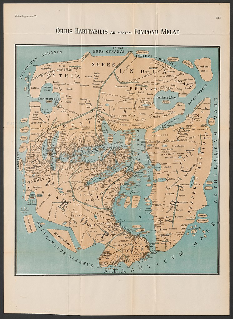
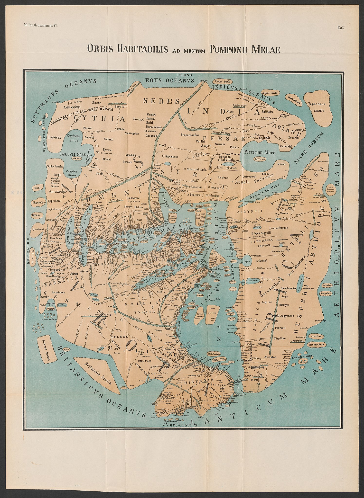
Deutsch: Weltkarte des Pomponius Mela in der Rekonstruktion von K. Miller (1898) English: World Map of Pomponius Mela as reconstructed by K. Miller (1898). |
| تاریخ | |
| ماخذ | "Orbis habitabilis ad mentem Pomponii Melae", Mappaemundi, Heft VI. "Rekonstruierte Karten", Tafel 7. |
| مصنف | Konrad Miller |
| دوسرے نسخے |
 |
.jpg)
اجازہ کاری
|
This work is in the public domain in its country of origin and other countries and areas where the copyright term is the author's life plus 70 years or fewer.
| |
| This file has been identified as being free of known restrictions under copyright law, including all related and neighboring rights. | |
فائل کا تاریخچہ
کسی خاص وقت یا تاریخ میں یہ فائل کیسی نظر آتی تھی، اسے دیکھنے کے لیے اس وقت/تاریخ پر کلک کریں۔
| تاریخ/وقت | تھمب نیل | ابعاد | صارف | تبصرہ | |
|---|---|---|---|---|---|
| رائج الوقت | 12:00، 2 جولائی 2020ء | | 12,449 × 17,055 (52.84 MB) | Sette-quattro | Higher quality from https://www.e-rara.ch/zut/content/zoom/11583686 |
| 13:18، 26 فروری 2015ء |  | 2,448 × 3,264 (2.91 MB) | Dbachmann | Reverted to version as of 19:54, 13 May 2008 | |
| 06:59، 19 فروری 2015ء |  | 2,328 × 2,650 (1.73 MB) | مانفی | color improved | |
| 04:54، 18 دسمبر 2010ء |  | 2,328 × 2,650 (1.97 MB) | Uploadalt | formatted | |
| 19:54، 13 مئی 2008ء |  | 2,448 × 3,264 (2.91 MB) | Fingalo | == Beschreibung == {{Information |Description=Weltkarte des Pomponius Mela |Source=Mappae Mundi Bd. Vi. "Rekonstruierte Karten" |Date=1898 |Author=Dr. Konrad Miller |Permission= |other_versions= }} Category:Fingalo Category:Old maps == [[Commons:C |
روابط
درج ذیل صفحہ اس فائل کو استعمال کر رہا ہے:
فائل کا عالمی استعمال
مندرجہ ذیل ویکیوں میں یہ فائل زیر استعمال ہے:
- als.wikipedia.org پر استعمال
- ar.wikipedia.org پر استعمال
- arz.wikipedia.org پر استعمال
- ast.wikipedia.org پر استعمال
- ba.wikipedia.org پر استعمال
- bg.wikipedia.org پر استعمال
- bn.wikipedia.org پر استعمال
- br.wikipedia.org پر استعمال
- ca.wikipedia.org پر استعمال
- da.wikipedia.org پر استعمال
- de.wikipedia.org پر استعمال
- el.wikipedia.org پر استعمال
- en.wikipedia.org پر استعمال
- eo.wikipedia.org پر استعمال
- es.wikipedia.org پر استعمال
- et.wikipedia.org پر استعمال
- eu.wikipedia.org پر استعمال
- fa.wikipedia.org پر استعمال
- fa.wikibooks.org پر استعمال
- fi.wikipedia.org پر استعمال
- fi.wikibooks.org پر استعمال
- fr.wikipedia.org پر استعمال
- fr.wiktionary.org پر استعمال
- gl.wikipedia.org پر استعمال
- he.wikipedia.org پر استعمال
اس فائل کا مزید عالمی استعمال دیکھیے۔