
فائل:Map-of-southeast-asia 900 CE.png
اصل فائل (791 × 1,114 پکسل، فائل کا حجم: 182 کلوبائٹ، MIME قسم: image/png)
khmerempire3.jpg
خلاصہ
| تفصیل |
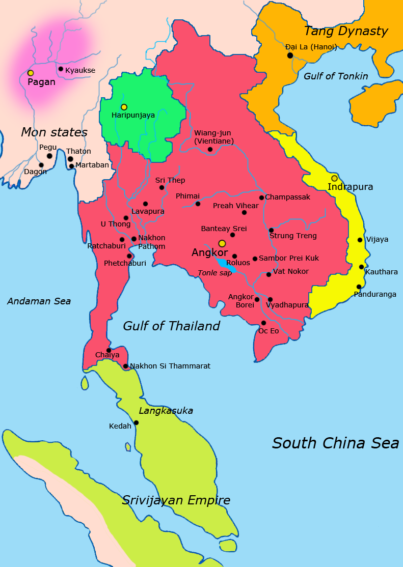
English: Map of Southeast Asia circa 900 CE, showing the Khmer Empire in red, Champa in yellow and Haripunjaya in light Green plus additional surrounding states.
sources i used for this work include http://ecaimaps.berkeley.edu/animations/2003_03_khmer_animation.swf http://www.britannica.com/EBchecked/media/3395/Khmer-empire-1200 Atlas of world history, Patrick Karl O'brien Societies, Networks, and Transitions: A Global History, Volume B. Craig A.Lockard http://upload.wikimedia.org/wikipedia/commons/thumb/4/45/Srivijaya_Empire.svg/2000px-Srivijaya_Empire.svg.png File:DvaravatiMapThailand.png http://upload.wikimedia.org/wikipedia/commons/e/eb/Thailand_2002_CIA_map.jpgBahasa Indonesia: Peta Asia Tenggara sekitar tahun 900 M, menampilkan Kerajaan Khmer dengan warna merah, Champa dengan warna kuning dan Haripunjaya dengan warna hijau beserta beberapa negara-negara lainnya. |
|||
| تاریخ | ||||
| ماخذ | ذاتی کام | |||
| مصنف | Javierfv1212 | |||
| دوسرے نسخے |
|


اجازہ کاری
| This file is made available under the Creative Commons CC0 1.0 Universal Public Domain Dedication. | |
| The person who associated a work with this deed has dedicated the work to the public domain by waiving all of their rights to the work worldwide under copyright law, including all related and neighboring rights, to the extent allowed by law. You can copy, modify, distribute and perform the work, even for commercial purposes, all without asking permission.
|
فائل کا تاریخچہ
کسی خاص وقت یا تاریخ میں یہ فائل کیسی نظر آتی تھی، اسے دیکھنے کے لیے اس وقت/تاریخ پر کلک کریں۔
| تاریخ/وقت | تھمب نیل | ابعاد | صارف | تبصرہ | |
|---|---|---|---|---|---|
| رائج الوقت | 14:13، 8 اپریل 2011ء | | 791 × 1,114 (182 کلوبائٹ) | Ras67 | cropped |
| 02:13، 28 مارچ 2011ء |  | 800 × 1,125 (222 کلوبائٹ) | Javierfv1212 | {{Information |Description ={{en|1=Map of South-east asia circa 900 CE, showing the Khmer Empire in red, Champa in yellow and Haripunjaya in light Green plus additional surrounding states. sources i used for this work include http://ecaimaps.berkele |
روابط
درج ذیل صفحہ اس فائل کو استعمال کر رہا ہے:
فائل کا عالمی استعمال
مندرجہ ذیل ویکیوں میں یہ فائل زیر استعمال ہے:
- af.wikipedia.org پر استعمال
- ar.wikipedia.org پر استعمال
- azb.wikipedia.org پر استعمال
- az.wikipedia.org پر استعمال
- bg.wikipedia.org پر استعمال
- ca.wikipedia.org پر استعمال
- ceb.wikipedia.org پر استعمال
- cs.wikipedia.org پر استعمال
- el.wikipedia.org پر استعمال
- en.wikipedia.org پر استعمال
- eo.wikipedia.org پر استعمال
- et.wikipedia.org پر استعمال
- eu.wikipedia.org پر استعمال
- fa.wikipedia.org پر استعمال
- fi.wikipedia.org پر استعمال
- fr.wikipedia.org پر استعمال
- gu.wikipedia.org پر استعمال
- he.wikipedia.org پر استعمال
- id.wikipedia.org پر استعمال
- it.wikipedia.org پر استعمال
- ja.wikipedia.org پر استعمال
- ka.wikipedia.org پر استعمال
- km.wikipedia.org پر استعمال
- lo.wikipedia.org پر استعمال
- lt.wikipedia.org پر استعمال
- mg.wikipedia.org پر استعمال
- ml.wikipedia.org پر استعمال
اس فائل کا مزید عالمی استعمال دیکھیے۔