
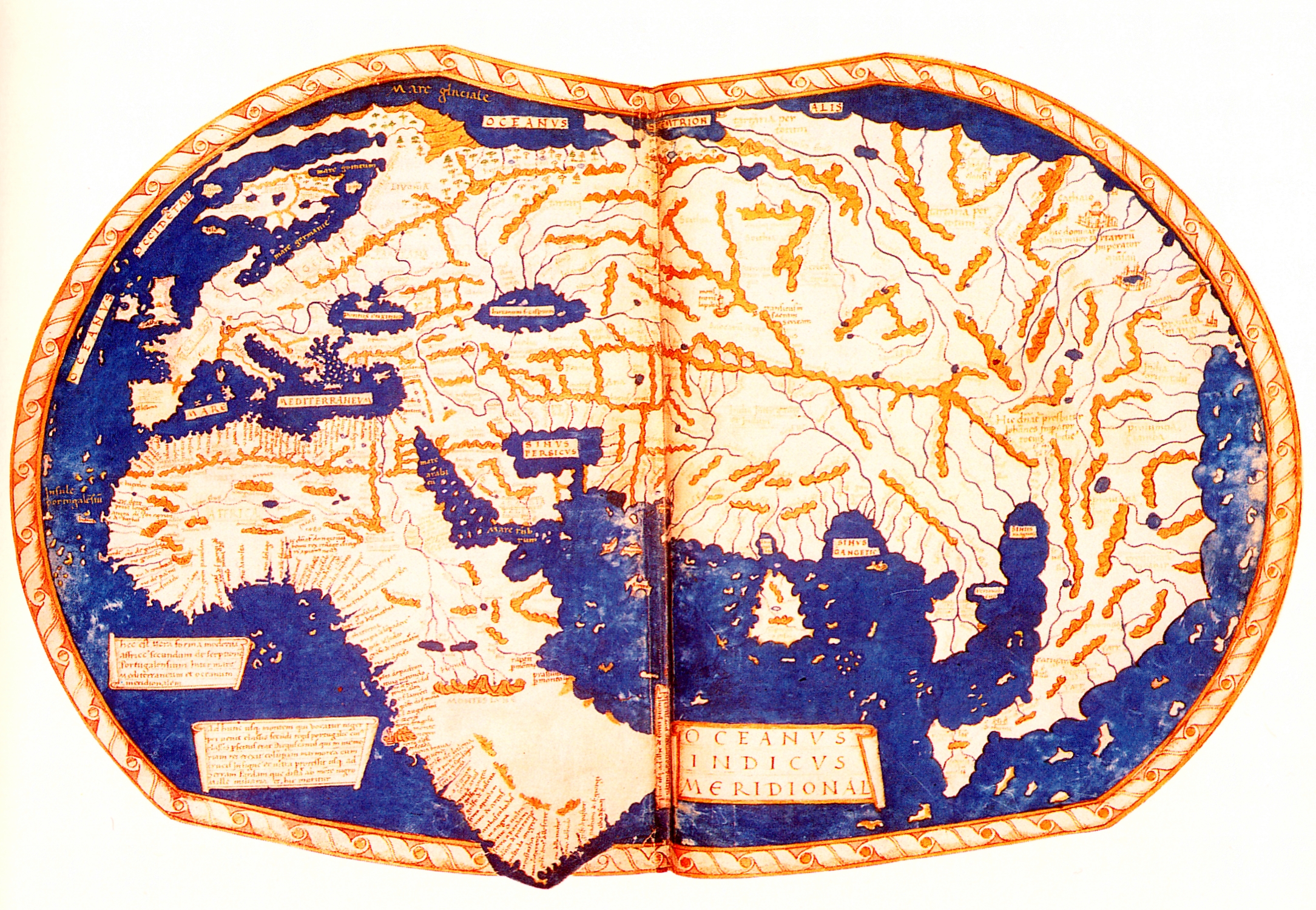
فائل:Martellus world map.jpg
اس نمائش کا حجم: 800 × 554 پکسلز۔ دیگر تصمیمات: 320 × 221 پکسلز | 640 × 443 پکسلز | 1,024 × 709 پکسلز | 1,280 × 886 پکسلز | 2,169 × 1,501 پکسلز۔
اصل فائل (2,169 × 1,501 پکسل، فائل کا حجم: 2.69 MB، MIME قسم: image/jpeg)
خلاصہ
| فن کار |
Heinrich Hammer the German ("Henricus Martellus Germanus") |
| مصنف |
Ptolemy (Κλαύδιος Πτολεμαῖος, Claudius Ptolemaeus) |
| تفصیل |
English: The world map of "Henricus Martellus Germanus" (Heinrich Hammer the German), Florence 1490-92. The first map with the Dragon Tail. It is a mixture of Ptolemy, recent Portuguese discoveries and unknown sources. Displays the Cape of Good Hope, rounded by Bartolomeo Dias in 1488. Deutsch: Weltkarte des de:Henricus Martellus Germanus |
| تاریخ | قریباً 1489 |
| ماخذ/مصور | Insularium Illustratum (Account of the Islands of the Mediterranean) |
| دوسرے نسخے |
|


.jpg)
,_ff.68v-69_-_BL_Add_MS_15760.jpg)

اجازہ کاری
|
This is a faithful photographic reproduction of a two-dimensional, public domain work of art. The work of art itself is in the public domain for the following reason:
The official position taken by the Wikimedia Foundation is that "faithful reproductions of two-dimensional public domain works of art are public domain".
This photographic reproduction is therefore also considered to be in the public domain in the United States. In other jurisdictions, re-use of this content may be restricted; see Reuse of PD-Art photographs for details. | ||||
فائل کا تاریخچہ
کسی خاص وقت یا تاریخ میں یہ فائل کیسی نظر آتی تھی، اسے دیکھنے کے لیے اس وقت/تاریخ پر کلک کریں۔
| تاریخ/وقت | تھمب نیل | ابعاد | صارف | تبصرہ | |
|---|---|---|---|---|---|
| رائج الوقت | 21:58، 20 فروری 2008ء | | 2,169 × 1,501 (2.69 MB) | Ziko | {{Information |Description=World map of Henricus Martellus Germanus (Heinrich Hammer) |Source=old |Date=ca. 1490 |Author= Ziko-C |Permission=see below |other_versions= }} Category:Mappae mundi |
روابط
درج ذیل صفحہ اس فائل کو استعمال کر رہا ہے:
فائل کا عالمی استعمال
مندرجہ ذیل ویکیوں میں یہ فائل زیر استعمال ہے:
- ast.wikipedia.org پر استعمال
- ca.wikipedia.org پر استعمال
- de.wikipedia.org پر استعمال
- el.wikipedia.org پر استعمال
- en.wikipedia.org پر استعمال
- es.wikipedia.org پر استعمال
- fa.wikipedia.org پر استعمال
- fa.wikibooks.org پر استعمال
- he.wikipedia.org پر استعمال
- it.wikipedia.org پر استعمال
- sl.wikipedia.org پر استعمال