
فائل:MountAkutan.jpg

اس نمائش کا حجم: 800 × 538 پکسلز۔ دیگر تصمیمات: 320 × 215 پکسلز | 640 × 430 پکسلز | 1,024 × 688 پکسلز۔
اصل فائل (1,024 × 688 پکسل، فائل کا حجم: 247 کلوبائٹ، MIME قسم: image/jpeg)
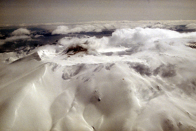
Aerial view of Akutan volcano that forms the west part of Akutan Island in the eastern Aleutian Islands. The volcano's summit is truncated by a 2-km-wide (1.2 mi) caldera that contains a cinder cone that has been the site of frequent historical eruptions. View is to the southeast.
Photograph by C. Nye, Alaska Division of Geological and Geophysical Surveys, May 10, 1994. Source: http://geopubs.wr.usgs.gov/dds/dds-40/
This image is in the public domain in the United States because it only contains materials that originally came from the United States Geological Survey, an agency of the United States Department of the Interior. For more information, see the official USGS copyright policy.
|
فائل کا تاریخچہ
کسی خاص وقت یا تاریخ میں یہ فائل کیسی نظر آتی تھی، اسے دیکھنے کے لیے اس وقت/تاریخ پر کلک کریں۔
| تاریخ/وقت | تھمب نیل | ابعاد | صارف | تبصرہ | |
|---|---|---|---|---|---|
| رائج الوقت | 12:55، 28 جنوری 2005ء | | 1,024 × 688 (247 کلوبائٹ) | GarciaB~commonswiki | Mount Akutan, Alaska |
روابط
درج ذیل صفحہ اس فائل کو استعمال کر رہا ہے:
فائل کا عالمی استعمال
مندرجہ ذیل ویکیوں میں یہ فائل زیر استعمال ہے:
- ca.wikipedia.org پر استعمال
- ceb.wikipedia.org پر استعمال
- cs.wikipedia.org پر استعمال
- de.wikipedia.org پر استعمال
- en.wikipedia.org پر استعمال
- es.wikipedia.org پر استعمال
- eu.wikipedia.org پر استعمال
- fi.wikipedia.org پر استعمال
- ga.wikipedia.org پر استعمال
- gv.wikipedia.org پر استعمال
- hy.wikipedia.org پر استعمال
- it.wikipedia.org پر استعمال
- ms.wikipedia.org پر استعمال
- nl.wikipedia.org پر استعمال
- no.wikipedia.org پر استعمال
- uk.wikipedia.org پر استعمال
- www.wikidata.org پر استعمال
- zh.wikipedia.org پر استعمال