
فائل:Mountain Fork Bridge.jpg

اس نمائش کا حجم: 471 × 599 پکسلز۔ دیگر تصمیمات: 189 × 240 پکسلز | 377 × 480 پکسلز | 604 × 768 پکسلز | 805 × 1,024 پکسلز | 1,611 × 2,048 پکسلز | 3,691 × 4,693 پکسلز۔
اصل فائل (3,691 × 4,693 پکسل، فائل کا حجم: 1.61 MB، MIME قسم: image/jpeg)
|
This is an image of a place or building that is listed on the National Register of Historic Places in the United States of America. Its reference number is 90000540. |
| Camera location | | View this and other nearby images on: OpenStreetMap |
|---|
| تفصیل |
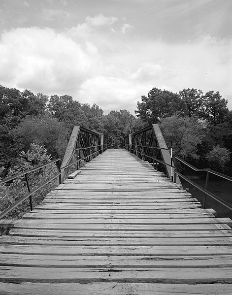
English: Looking west on the Mountain Fork Bridge, which carries County Road 38 over Mountain Fork Creek near Mena in Saline County, Arkansas, United States. Built in 1926, this Pratt pony truss bridge is listed on the National Register of Historic Places. |
||||
| تاریخ | |||||
| ماخذ | Library of Congress, Prints and Photograph Division HAER: ARK,57-CAPI.V,1-3 | ||||
| مصنف | Jeff Holder | ||||
| اجازت (فائل کا دوبارہ استعمال) |
|

|
This image is available from the United States Library of Congress's Prints and Photographs division
under the digital ID hhh.ar0092. This tag does not indicate the copyright status of the attached work. A normal copyright tag is still required. See Commons:Licensing.
|
فائل کا تاریخچہ
کسی خاص وقت یا تاریخ میں یہ فائل کیسی نظر آتی تھی، اسے دیکھنے کے لیے اس وقت/تاریخ پر کلک کریں۔
| تاریخ/وقت | تھمب نیل | ابعاد | صارف | تبصرہ | |
|---|---|---|---|---|---|
| رائج الوقت | 02:03، 13 دسمبر 2009ء | | 3,691 × 4,693 (1.61 MB) | Nyttend | {{Location|34|31|41|N|94|24|0|W}} {{Information |Description={{en|Looking west on the {{w|Mountain Fork Bridge}}, which carries County Road 38 over Mountain Fork Creek near {{w|Mena, Arkansas|Mena}} in {{w|Saline County, Arkansas|Saline County}}, {{w|Arka |
روابط
درج ذیل صفحہ اس فائل کو استعمال کر رہا ہے:
فائل کا عالمی استعمال
مندرجہ ذیل ویکیوں میں یہ فائل زیر استعمال ہے:
- ar.wikipedia.org پر استعمال
- ceb.wikipedia.org پر استعمال
- ce.wikipedia.org پر استعمال
- cy.wikipedia.org پر استعمال
- en.wikipedia.org پر استعمال
- es.wikipedia.org پر استعمال
- fr.wikipedia.org پر استعمال
- ga.wikipedia.org پر استعمال
- hu.wikipedia.org پر استعمال
- hy.wikipedia.org پر استعمال
- ki.wikipedia.org پر استعمال
- no.wikipedia.org پر استعمال
- pl.wikipedia.org پر استعمال
- ru.wikipedia.org پر استعمال
- sr.wikipedia.org پر استعمال
- tt.wikipedia.org پر استعمال
- www.wikidata.org پر استعمال
- zh-min-nan.wikipedia.org پر استعمال