
فائل:Nunhead Station (geograph 4439124).jpg

اصل فائل (1,600 × 1,064 پکسل، فائل کا حجم: 434 کلوبائٹ، MIME قسم: image/jpeg)
.jpg)
خلاصہ
| تفصیل |
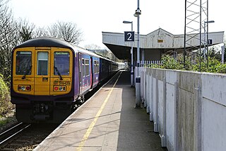
English: Nunhead Station The station was built by the Southern Railway in 1925 as part of the electrification of the route. It replaced the original Nunhead Junction station which was situated on the opposite side of Gibbon Road. There are some characteristic Southern Railway features on display - the W-shaped platform awning and the concrete fence panels are typical of that railway company. Interestingly, beyond the central area of the station and its awning the platforms are separate - presumably a cost saving measure. |
| تاریخ | |
| ماخذ | From geograph.org.uk |
| مصنف | Martin Addison |
| اجازت (فائل کا دوبارہ استعمال) |
Creative Commons Attribution Share-alike license 2.0 |
| لگاؤ (required by the license) | Martin Addison / Nunhead Station / |
| Camera location | | View this and other nearby images on: OpenStreetMap |
|---|
.jpg¶ms=051.467030_N_-000.053900_E_globe:Earth_type:camera_source:geograph-osgb36(TQ35277602)_heading:90.00&language=ur)
| Object location | | View this and other nearby images on: OpenStreetMap |
|---|
.jpg¶ms=051.467020_N_-000.053300_E_globe:Earth_class:object_type:object_source:geograph-osgb36(TQ35317602)_heading:90.00&language=ur)
اجازہ کاری

|
This image was taken from the Geograph project collection. See this photograph's page on the Geograph website for the photographer's contact details. The copyright on this image is owned by Martin Addison and is licensed for reuse under the Creative Commons Attribution-ShareAlike 2.0 license.
|
- آپ آزاد ہیں:
- شیئر کرنے – کام کو نقل، تقسیم یا منتقل کرنے کے لیے
- ریمکس کے لیے – کام منبطق کرنے کے لیے
- مندرجہ ذیل شرائط کے تحت:
- انتساب – آپ کو اس کام کا انتساب مصنف یا اجازت دہندہ کے بتائے گئے طریقہ کے مطابق دینا ہوگا (تاہم یہ انتساب اس طرح نہیں ہونا چاہیے کہ اسے دیکھ کر ایسا محسوس ہو کہ اصل مصنف یا اجازت دہندہ آپ کے یا آپ کے ذریعہ اس کام کے استعمال کرنے کے حامی ہیں)۔
- یکساں شراکت – اگر آپ اس کام میں کوئی تبدیلی یا ترمیم کرتے ہیں یا اس کام پر مبنی کچھ نیا بناتے ہیں تو اسے بھی آپ اسی یا اس جیسے کسی اجازت نامے کے تحت شائع کر سکتے ہیں۔
فائل کا تاریخچہ
کسی خاص وقت یا تاریخ میں یہ فائل کیسی نظر آتی تھی، اسے دیکھنے کے لیے اس وقت/تاریخ پر کلک کریں۔
| تاریخ/وقت | تھمب نیل | ابعاد | صارف | تبصرہ | |
|---|---|---|---|---|---|
| رائج الوقت | 11:31، 9 اکتوبر 2015ء | | 1,600 × 1,064 (434 کلوبائٹ) | Lamberhurst | == {{int:filedesc}} == {{Information |Description={{en|1='''Nunhead Station'''<br/> The station was built by the Southern Railway in 1925 as part of the electrification of the route. It replaced the original Nunhead Junction station which was situated... |
روابط
درج ذیل صفحہ اس فائل کو استعمال کر رہا ہے:
فائل کا عالمی استعمال
مندرجہ ذیل ویکیوں میں یہ فائل زیر استعمال ہے:
- en.wikipedia.org پر استعمال
.jpg)