
فائل:Partitions of Poland.png

اس نمائش کا حجم: 765 × 600 پکسلز۔ دیگر تصمیمات: 306 × 240 پکسلز | 612 × 480 پکسلز | 980 × 768 پکسلز | 1,280 × 1,004 پکسلز | 2,000 × 1,568 پکسلز۔
اصل فائل (2,000 × 1,568 پکسل، فائل کا حجم: 261 کلوبائٹ، MIME قسم: image/png)
| تفصیل |
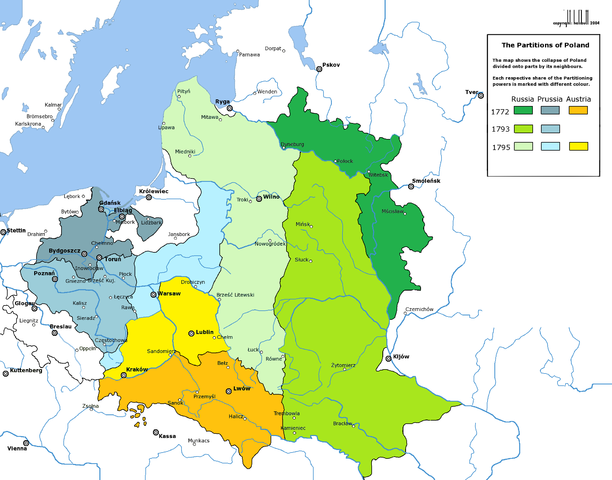
English: Partitions of the Polish-Lithuanian Commonwealth in 1772, 1793 and 1795.
Deutsch: Die Teilungen Polen-Litauens 1772, 1793 und 1795. |
| تاریخ | (UTC) |
| ماخذ | |
| مصنف |
|
| دوسرے نسخے | العربيَّة |
| This is a retouched picture, which means that it has been digitally altered from its original version. Modifications: new colours. The original can be viewed here: Rzeczpospolita Rozbiory 3.png:
|

|
This historical map image could be re-created using vector graphics as an SVG file. This has several advantages; see Commons:Media for cleanup for more information. If an SVG form of this image is available, please upload it and afterwards replace this template with
{{vector version available|new image name}}.
It is recommended to name the SVG file “Partitions of Poland.svg”—then the template Vector version available (or Vva) does not need the new image name parameter. |
میں اس تخلیقی کام کے حقوق کا مالک ہوں اور اسے مندرجہ ذیل اجازت نامے کے تحت شائع کرتا ہوں:

|
آپ کو آزاد سافٹ ویئر فاؤنڈیشن کی جانب سے شائع کردہ جی این یو آزاد مسوداتی اجازت نامہ کی شرائط استعمال کے تحت اس دستاویز کو نقل، تقسیم اور/ یا ترمیم کرنے کی اجازت دی جاتی ہے۔ اس اجازت نامہ کی ایک نقل 'جی این یو آزاد مسوداتی اجازت نامہ کے عنوان سے میسر ہے۔ |
| اس ملف کا لائسنس Creative Commons Attribution-Share Alike 3.0 Unported کے تحط ہے۔ | ||
| ||
| This licensing tag was added to this file as part of the GFDL licensing update. |
اولین اپلوڈ کا نوشتہ
This image is a derivative work of the following images:
- File:Rzeczpospolita_Rozbiory_3.png licensed with GFDL
- 2006-02-16T21:06:11Z Tomekpe 2000x1568 (246810 Bytes) Corrected mistakes: * Silesia at the time belonged to Prussia, whereas the map shows it belonging to Austria.
- 2005-12-25T21:52:24Z Tomekpe 2000x1568 (247161 Bytes) Halibutt's graphic with changing polish-russian border (Krasny Horodok area).
- 2005-01-10T13:41:59Z Halibutt 2000x1568 (343225 Bytes) Partitions of the [[Polish-Lithuanian Commonwealth]]{{User:Halibutt/maps}}{{User:Halibutt/GFDL}}[[Category:Maps of Poland]][[Category:Historical maps]]
Uploaded with derivativeFX
فائل کا تاریخچہ
کسی خاص وقت یا تاریخ میں یہ فائل کیسی نظر آتی تھی، اسے دیکھنے کے لیے اس وقت/تاریخ پر کلک کریں۔
| تاریخ/وقت | تھمب نیل | ابعاد | صارف | تبصرہ | |
|---|---|---|---|---|---|
| رائج الوقت | 07:57، 13 مارچ 2009ء | | 2,000 × 1,568 (261 کلوبائٹ) | Sneecs | Legendenfarben waren vertauscht |
| 20:03، 5 مارچ 2009ء |  | 2,000 × 1,568 (261 کلوبائٹ) | Sneecs | {{Information |Description= |Source=*File:Rzeczpospolita_Rozbiory_3.png |Date=2009-03-05 19:59 (UTC) |Author=*File:Rzeczpospolita_Rozbiory_3.png: Halibutt *derivative work: ~~~ |Permission=see below |other_versions= }} {{RetouchedPicture|new |
روابط
درج ذیل صفحہ اس فائل کو استعمال کر رہا ہے:
فائل کا عالمی استعمال
مندرجہ ذیل ویکیوں میں یہ فائل زیر استعمال ہے:
- als.wikipedia.org پر استعمال
- ar.wikipedia.org پر استعمال
- azb.wikipedia.org پر استعمال
- az.wikipedia.org پر استعمال
- be-tarask.wikipedia.org پر استعمال
- be.wikipedia.org پر استعمال
- bg.wikipedia.org پر استعمال
- br.wikipedia.org پر استعمال
- ca.wikipedia.org پر استعمال
- cdo.wikipedia.org پر استعمال
- cs.wikipedia.org پر استعمال
- da.wikipedia.org پر استعمال
- de.wikipedia.org پر استعمال
- el.wikipedia.org پر استعمال
- en.wikipedia.org پر استعمال
- eo.wikipedia.org پر استعمال
اس فائل کا مزید عالمی استعمال دیکھیے۔