
فائل:PeelMap.png
اس نمائش کا حجم: 250 × 599 پکسلز۔ دیگر تصمیمات: 100 × 240 پکسلز | 200 × 480 پکسلز۔
اصل فائل (800 × 1,918 پکسل، فائل کا حجم: 123 کلوبائٹ، MIME قسم: image/png)
خلاصہ
| تفصیل |
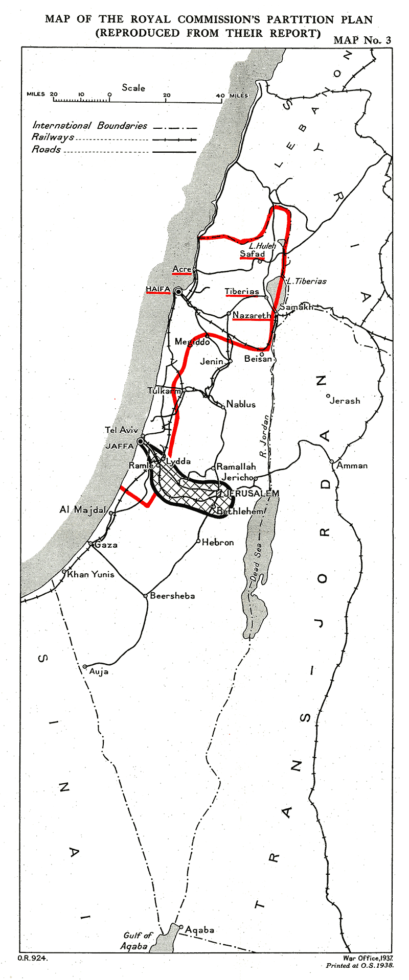
English: Provisional frontiers of the Palestine partition according to the Palestine Royal Commission (Peel report)
العربية: الحدود المؤقتة لتقسيم فلسطين حسب الهيئة الملكية الفلسطينية (تقرير بيل) |
| تاریخ | |
| ماخذ |
 |
| مصنف | UK Government |
اجازہ کاری
This work created by the United Kingdom Government is in the public domain.
This is because it is one of the following:
HMSO has declared that the expiry of Crown Copyrights applies worldwide (ref: HMSO Email Reply)
|
 |
فائل کا تاریخچہ
کسی خاص وقت یا تاریخ میں یہ فائل کیسی نظر آتی تھی، اسے دیکھنے کے لیے اس وقت/تاریخ پر کلک کریں۔
| تاریخ/وقت | تھمب نیل | ابعاد | صارف | تبصرہ | |
|---|---|---|---|---|---|
| رائج الوقت | 14:40، 26 ستمبر 2011ء | | 800 × 1,918 (123 کلوبائٹ) | Zero0000 |
روابط
درج ذیل صفحہ اس فائل کو استعمال کر رہا ہے:
فائل کا عالمی استعمال
مندرجہ ذیل ویکیوں میں یہ فائل زیر استعمال ہے:
- ar.wikipedia.org پر استعمال
- en.wikipedia.org پر استعمال
- eo.wikipedia.org پر استعمال
- es.wikipedia.org پر استعمال
- he.wikipedia.org پر استعمال
- id.wikipedia.org پر استعمال
- ml.wikipedia.org پر استعمال
- nl.wikipedia.org پر استعمال
- pnb.wikipedia.org پر استعمال
- pt.wikipedia.org پر استعمال
- www.wikidata.org پر استعمال
- zh.wikipedia.org پر استعمال