
فائل:Piri reis world map 01.jpg

اصل فائل (1,964 × 2,619 پکسل، فائل کا حجم: 7.08 MB، MIME قسم: image/jpeg)
خلاصہ
|
| تفصیل |
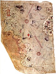
العربية: خارطة العالم بِيد أمير البحار العُثماني حاجي أحمد مُحيي الدين پیري، الشهير باسم پيري ريِّس، رُسمت سنة 1513م. لم يبقَ اليوم سوى نصف الخارطة الأصليَّة، التي يُحتفظ بها في متحف سراي طوپ قاپي في إسطنبول. تجمع هذه الخارطة معلومات من حوالي عشرين خريطة أُخرى، بما فيها إحدى الخرائط التي وضعها كريستوفر كولومبوس بنفسه وخطط فيها سواحل العالم الجديد.
English: Map of the world by Ottoman admiral Piri Reis, drawn in 1513. Only part of the original map survives and is held at the Topkapi Museum in Istanbul. The map synthesizes information from many maps, including one drawn by Christopher Columbus of the Caribbean.
Türkçe: Osmanlı amirali Piri Reis tarafından 1513'te çizilmiş olan, Avrupa ve Afrika'nın batı kıyılarıyla Güney Amerika'nın doğu kıyılarını gösteren dünyanın en eski haritalarından biri olan Piri Reis'in ilk Dünya haritası. |
| تاریخ | |
| ماخذ | Library of Topkapi Palace Museum, No. H 1824 Bilkent University (lo res), erisi.com (hi res) |
| مصنف |

اجازہ کاری
|
This is a faithful photographic reproduction of a two-dimensional, public domain work of art. The work of art itself is in the public domain for the following reason:
The official position taken by the Wikimedia Foundation is that "faithful reproductions of two-dimensional public domain works of art are public domain".
This photographic reproduction is therefore also considered to be in the public domain in the United States. In other jurisdictions, re-use of this content may be restricted; see Reuse of PD-Art photographs for details. | ||||
| Annotations | This image is annotated: View the annotations at Commons |
فائل کا تاریخچہ
کسی خاص وقت یا تاریخ میں یہ فائل کیسی نظر آتی تھی، اسے دیکھنے کے لیے اس وقت/تاریخ پر کلک کریں۔
| تاریخ/وقت | تھمب نیل | ابعاد | صارف | تبصرہ | |
|---|---|---|---|---|---|
| رائج الوقت | 23:16، 17 جولائی 2017ء | | 1,964 × 2,619 (7.08 MB) | Earthsound | Reverted to version as of 04:00, 17 August 2012 (UTC) The higher resolution images that replaced this are horribly pixelated and have been created by enlarging a much smaller copy. |
| 12:45، 13 نومبر 2016ء |  | 3,387 × 4,807 (2.16 MB) | Alonso de Mendoza | color | |
| 13:19، 5 مارچ 2016ء |  | 3,387 × 4,807 (1.6 MB) | ديفيد عادل وهبة خليل 2 | Cropped 5 % horizontally and 5 % vertically using CropTool with precise mode. | |
| 10:37، 23 نومبر 2014ء |  | 3,564 × 5,040 (1,019 کلوبائٹ) | Ratzer | higher Resolution 3564 x 5040, source http://www.erisi.com/gelisim/harita/pri/piri_dunya.jpg | |
| 04:00، 17 اگست 2012ء |  | 1,964 × 2,619 (7.08 MB) | FunkMonk | ||
| 02:45، 10 فروری 2008ء |  | 2,000 × 2,753 (2.27 MB) | FunkMonk | {{Information |Description= |Source= |Date= |Author= |Permission= |other_versions= }} | |
| 14:45، 13 ستمبر 2006ء |  | 829 × 1,087 (205 کلوبائٹ) | InfoCan | rotated previous version of map so North is up. | |
| 07:09، 29 ستمبر 2005ء |  | 1,087 × 829 (338 کلوبائٹ) | CristianChirita | Piri Reis World Map |
روابط
درج ذیل 2 صفحات اس فائل کو استعمال کر رہے ہیں:
فائل کا عالمی استعمال
مندرجہ ذیل ویکیوں میں یہ فائل زیر استعمال ہے:
- ar.wikipedia.org پر استعمال
- جزر الأنتيل
- بوابة:الدولة العثمانية/صورة
- ويكيبيديا:صور مختارة/رسومات وجداول وخرائط/خرائط
- بيري ريس
- خريطة بيري ريس
- ويكيبيديا:ترشيحات الصور المختارة/خريطة أحمد محيي الدين امريكا
- ويكيبيديا:صورة اليوم المختارة/مايو 2016
- قالب:صورة اليوم المختارة/2016-05-23
- بوابة:الدولة العثمانية/صورة مختارة/19
- ويكيبيديا:صورة اليوم المختارة/أغسطس 2017
- قالب:صورة اليوم المختارة/2017-08-22
- ويكيبيديا:صورة اليوم المختارة/يوليو 2019
- قالب:صورة اليوم المختارة/2019-07-23
- كتاب الملاحة
- ويكيبيديا:صورة اليوم المختارة/يناير 2022
- قالب:صورة اليوم المختارة/2022-01-15
- azb.wikipedia.org پر استعمال
- az.wikipedia.org پر استعمال
- bg.wikipedia.org پر استعمال
- bn.wikipedia.org پر استعمال
- ca.wikipedia.org پر استعمال
- cbk-zam.wikipedia.org پر استعمال
- ckb.wikipedia.org پر استعمال
- cs.wikipedia.org پر استعمال
- da.wikipedia.org پر استعمال
- de.wikipedia.org پر استعمال
- 1513
- Piri Reis
- Karte des Piri Reis
- Antillen
- Entwicklungsgeschichte der Seekarte
- Portal Diskussion:Türkei/Bild der Woche/Kandidaten/Archiv/2008
- Benutzer:DasAugeDerWahrheit
- Portal Diskussion:Türkei/Archiv/2009
- Portal:Türkei/Bild/Archiv
- Charles Hapgood
- Liste historischer Weltkarten
- Theorie der muslimischen Entdeckung Amerikas
- en.wikipedia.org پر استعمال
اس فائل کا مزید عالمی استعمال دیکھیے۔