
فائل:Punjab-Districts 1911.png
Punjab-Districts_1911.png (569 × 448 پکسل، فائل کا حجم: 113 کلوبائٹ، MIME قسم: image/png)
خلاصہ
| تفصیل |
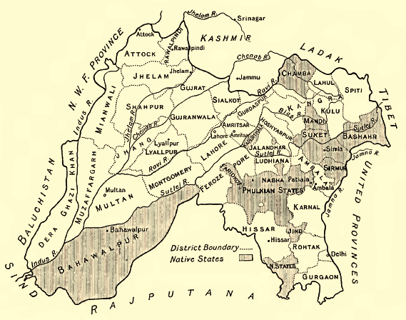
English: Map of the Districts and some Indian Princely States (Bahawalpur, Sirmur, Suket, Chamba etc.) of the Punjab, 1911
Deutsch: Karte der Distrikte des Punjab und einiger darin eingeschlossener indischer Fürstenstaaten (Bahawalpur, Sirmur, Suket, Chamba ), 1911. Höhenangaben in Fuß. |
| تاریخ | |
| ماخذ | Provincial Geographies of India, Vol. III |
| مصنف | Sir Henry |
اجازہ کاری
|
This work is in the public domain in its country of origin and other countries and areas where the copyright term is the author's life plus 70 years or fewer.
| |
| This file has been identified as being free of known restrictions under copyright law, including all related and neighboring rights. | |
فائل کا تاریخچہ
کسی خاص وقت یا تاریخ میں یہ فائل کیسی نظر آتی تھی، اسے دیکھنے کے لیے اس وقت/تاریخ پر کلک کریں۔
| تاریخ/وقت | تھمب نیل | ابعاد | صارف | تبصرہ | |
|---|---|---|---|---|---|
| رائج الوقت | 08:12، 29 جون 2014ء | | 569 × 448 (113 کلوبائٹ) | Xufanc | sepia color |
| 15:36، 18 جنوری 2010ء |  | 569 × 448 (149 کلوبائٹ) | Zenwort | {{Information |Description={{en|1=Map of the Districts and some Indian Princely States of the Punjab, 1911}} {{de|1=Karte der Distrikte des Punjab und einiger darin eingeschlossener indischer Fürstenstaaten, 1911. Höhenangaben in Fuß.}} |Source=Provinc |
روابط
درج ذیل صفحہ اس فائل کو استعمال کر رہا ہے:
فائل کا عالمی استعمال
مندرجہ ذیل ویکیوں میں یہ فائل زیر استعمال ہے:
- bn.wikipedia.org پر استعمال
- ca.wikipedia.org پر استعمال
- de.wikipedia.org پر استعمال
- en.wikipedia.org پر استعمال
- es.wikipedia.org پر استعمال
- fr.wikipedia.org پر استعمال
- hi.wikipedia.org پر استعمال
- id.wikipedia.org پر استعمال
- it.wikipedia.org پر استعمال
- pa.wikipedia.org پر استعمال
- pnb.wikipedia.org پر استعمال
- ru.wikipedia.org پر استعمال
- ta.wikipedia.org پر استعمال
اس فائل کا مزید عالمی استعمال دیکھیے۔