
فائل:RomanEmpire 117.svg

اس SVG فائل کی PNG نمائش کا حجم: 512 × 376 پکسلز دیگر تصمیمات: 320 × 235 پکسلز | 640 × 470 پکسلز | 1,024 × 752 پکسلز | 1,280 × 940 پکسلز | 2,560 × 1,880 پکسلز۔
اصل فائل (ایس وی جی فائل، ابعاد 512 × 376 پکسل، فائل کا حجم: 704 کلوبائٹ)
خلاصہ
| تفصیل |
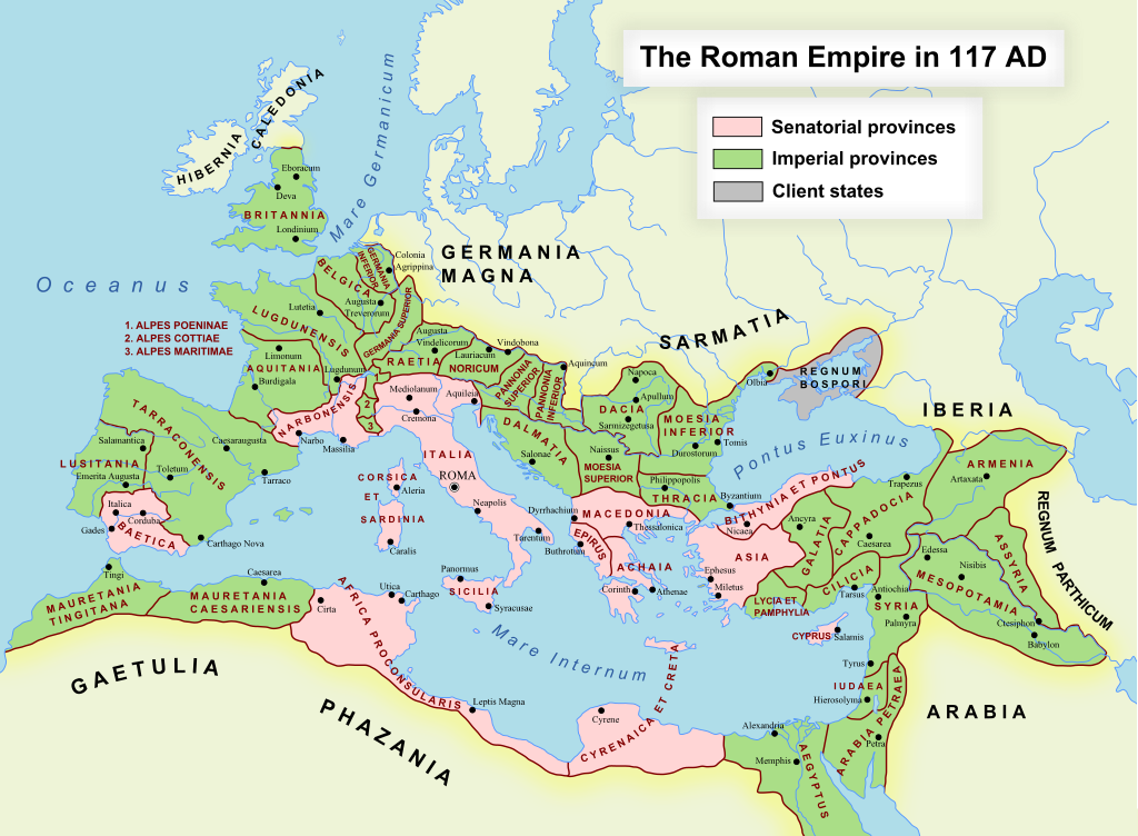
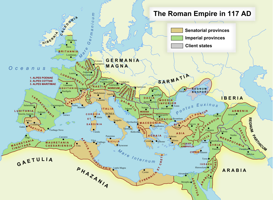
English: The maximum extent of the Roman Empire. Superimposed on a physical map. Senatorial Provinces Imperial Provinces Client States Español: Máxima extensión del Imperio Romano. Superpuesto en un mapa físico. Provincias Senatoriales Provincias Imperiales Estados satélite Deutsch: Das Römische Reich zur Zeit seiner maximalen Ausdehnung unter Trajan, 117 n. Chr. Senatorische Provinz Kaiserliche Provinz Klientelkönigtum Latina: Extentum maximum de Imperium Romanum. Provinciae senatus Provinciae Imperii Civitates Clientes 中文:公元117年图拉真在位时期罗马帝国的最大疆域。 元老院行省 元首行省 附庸国 日本語: ローマ帝国の最大版図。(西暦117年、皇帝トラヤヌス) 元老院属州 皇帝属州 従属国 |
| تاریخ | 17 اکتوبر 2005 (first version); 19 دسمبر 2007 (last version) |
| ماخذ | Transferred from en.wikipedia to Commons. |
| مصنف | ArdadN at انگریزی ویکیپیڈیا |
| اجازت (فائل کا دوبارہ استعمال) |
Public Domain |
| دوسرے نسخے |
[]
|
| SVG genesis |


SVG Support
This document is in the Scalable Vector Graphic format (SVG) and requires a supported browser (Firefox, Google Chrome, Opera) or a SVG plugin for Internet Explorer and other browsers. SVG is an open, text-based format, which means this map can be downloaded and modified/translated completely using a vector graphics editor like Adobe Illustrator or Inkscape (free) or a text editor such as Notepad.
| BLANK THUMBNAIL | View large PNG | View medium PNG | SVG Plugin for Internet Explorer and other browsers |
|---|---|---|---|
| Click here (purge cache) and then CTRL+F5 to reload. Help? | Try 1 Try 2 | Try 1 Try 2 | Adobe SVG plugin |
| Recommended browser | More Help | ||
| Firefox | List of SVG tools |
اجازہ کاری
اس تخلیقی کام کے حقوق کا مالک ArdadN at انگریزی ویکیپیڈیا اسے مندرجہ ذیل اجازت نامے کے تحت شائع کرتا ہے:
| میں اس تخلیقی کام کے حقوق کا مالک ہوں اور اسے دائرہ عام میں شائع کرتا ہوں جس کا اطلاق عالمی سطح پر ہوتا ہے۔ بعض ملکوں میں یہ قانونی طور پر شاید ممکن نہ ہو؛ اگر ایسا ہے تو: میں ہر ایک کو کسی بھی مقصد کے لیے بغیر کسی شرط کے اس تصویر کے استعمال کا حق تفویض کرتا/کرتی ہوں، بجز اس صورت کے جس میں کوئی قانونی رکاوٹ موجود ہو۔ |
فائل کا تاریخچہ
کسی خاص وقت یا تاریخ میں یہ فائل کیسی نظر آتی تھی، اسے دیکھنے کے لیے اس وقت/تاریخ پر کلک کریں۔
| تاریخ/وقت | تھمب نیل | ابعاد | صارف | تبصرہ | |
|---|---|---|---|---|---|
| رائج الوقت | 11:48، 24 نومبر 2022ء | | 512 × 376 (704 کلوبائٹ) | Vikarna | alpes poeniae → alpes poeninae |
| 02:36، 2 ستمبر 2021ء |  | 512 × 376 (696 کلوبائٹ) | OgreBot | (BOT): Reverting to most recent version before archival | |
| 02:36، 2 ستمبر 2021ء |  | 2,180 × 1,600 (1.96 MB) | OgreBot | (BOT): Uploading old version of file from en.wikipedia; originally uploaded on 2008-12-10 00:59:00 by Andrein | |
| 02:36، 2 ستمبر 2021ء |  | 2,180 × 1,600 (1.96 MB) | OgreBot | (BOT): Uploading old version of file from en.wikipedia; originally uploaded on 2008-12-10 00:54:46 by Andrein | |
| 02:36، 2 ستمبر 2021ء |  | 2,180 × 1,600 (1.96 MB) | OgreBot | (BOT): Uploading old version of file from en.wikipedia; originally uploaded on 2008-12-10 00:22:12 by Andrein | |
| 02:36، 2 ستمبر 2021ء |  | 2,180 × 1,600 (1.94 MB) | OgreBot | (BOT): Uploading old version of file from en.wikipedia; originally uploaded on 2008-12-09 20:41:09 by Andrein | |
| 02:36، 2 ستمبر 2021ء |  | 2,180 × 1,600 (639 کلوبائٹ) | OgreBot | (BOT): Uploading old version of file from en.wikipedia; originally uploaded on 2008-09-18 15:26:52 by Andrein | |
| 02:35، 2 ستمبر 2021ء |  | 2,180 × 1,600 (639 کلوبائٹ) | OgreBot | (BOT): Uploading old version of file from en.wikipedia; originally uploaded on 2008-08-28 12:12:21 by Andrein | |
| 02:17، 2 اگست 2019ء |  | 512 × 376 (696 کلوبائٹ) | Vikarna | there was a dot out of the map. | |
| 23:13، 30 اگست 2018ء |  | 2,180 × 1,600 (1.11 MB) | Begoon | . |
روابط
درج ذیل 23 صفحات اس فائل کو استعمال کر رہے ہیں:
- آخیا (رومی صوبہ)
- افریقا (رومی صوبہ)
- رومی اطالیہ
- رومی برطانیہ
- رومی قبرص
- ساردینیا اور کورسکا
- سوریہ (رومی صوبہ)
- صقلیہ (رومی صوبہ)
- مصر (رومی صوبہ)
- مقدونیہ (رومی صوبہ)
- موئسیا
- کلاسیکی عہد
- گالیا لوگڈونینسیس
- گلاشیا
- گلتیہ (رومی صوبہ)
- یہودا (رومی صوبہ)
- صارف:Ulubatli Hasan/
- صارف:Ulubatli Hasan/صارف سانچہ
- سانچہ:ء میں رومن صوبے 117
- سانچہ:رومی صوبے 117 عیسوی
- سانچہ:صارف قدیم روم
- سانچہ:صارف قدیم روم 2
- مسودہ:خانہ معلومات درکار تصاویر والے مضامین
فائل کا عالمی استعمال
مندرجہ ذیل ویکیوں میں یہ فائل زیر استعمال ہے:
- af.wikipedia.org پر استعمال
- Gallia Narbonensis
- Gallia Belgica
- Sjabloon:Romeinse provinsies 117 n.C.
- Gallia Aquitania
- Germania Inferior
- Germania Superior
- Thracië
- Kappadosië
- Lusitania (Romeinse provinsie)
- Koninkryk Iberië
- Epirus
- Osroene
- Wikipedia:Geselshoekie/Taalforum
- Britannia (provinsie)
- Dalmasië
- Numidië
- Achaea (Romeinse provinsie)
- Aegyptus (Romeinse provinsie)
- Africa (Romeinse provinsie)
- Alpes Cottiae
- Alpes Maritimae
- Alpes Poenninae
- Arabia Petraea
- Armenia Inferior
- Asia (Romeinse provinsie)
- Assyria (Romeinse provinsie)
- Bithynia (Romeinse provinsie)
- Cilicia
- Commagene
- Corsica et Sardinia
- Creta et Cyrenaica
- Dacia (Romeinse provinsie)
- Galatia (Romeinse provinsie)
- Gallia Lugdunensis
- Hispania Baetica
- Hispania Tarraconensis
- Italia (Romeinse Ryk)
- Iudaea (Romeinse provinsie)
- Lycaonia
- Lycia et Pamphylia
- Macedonia (Romeinse provinsie)
- Mauretania Caesariensis
- Mauretania Tingitana
- Moesia Superior
- Noricum
- Pannonia
- Pamphylia
- Pisidia
- Raetia
- Sicilia (Romeinse provinsie)
اس فائل کا مزید عالمی استعمال دیکھیے۔