
فائل:Round Tower - Clondalkin - geograph.org.uk - 108911.jpg
اس نمائش کا حجم: 449 × 600 پکسلز۔ دیگر تصمیمات: 179 × 240 پکسلز | 479 × 640 پکسلز۔
اصل فائل (479 × 640 پکسل، فائل کا حجم: 66 کلوبائٹ، MIME قسم: image/jpeg)
خلاصہ
| تفصیل |
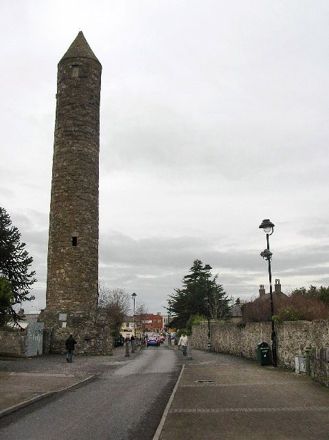
English: Round Tower - Clondalkin. Well preserved 8th century round tower that acts as a focal point for the area. Acknowledged as one of the oldest and best preserved in the country, it is 84 feet high and has its original conical cap. The foundation of the first monastery is attributed to St. Cronan, otherwise called Mo-Chua, who lived possibly in the 6th century. The monastery is first mentioned in 776. It was plundered by the Vikings in 832. [info from http://www.irish-architecture.com] |
| تاریخ | |
| ماخذ | From geograph.org.uk |
| مصنف | Paul Johnston-Knight |
| لگاؤ (required by the license) | Paul Johnston-Knight / Round Tower - Clondalkin / |
| Object location | | View this and other nearby images on: OpenStreetMap |
|---|
_heading:0.00&language=ur)
اجازہ کاری

|
This image was taken from the Geograph project collection. See this photograph's page on the Geograph website for the photographer's contact details. The copyright on this image is owned by Paul Johnston-Knight and is licensed for reuse under the Creative Commons Attribution-ShareAlike 2.0 license.
|
This file is licensed under the Creative Commons Attribution-Share Alike 2.0 Generic license.
لگاؤ: Paul Johnston-Knight
- آپ آزاد ہیں:
- شیئر کرنے – کام کو نقل، تقسیم یا منتقل کرنے کے لیے
- ریمکس کے لیے – کام منبطق کرنے کے لیے
- مندرجہ ذیل شرائط کے تحت:
- انتساب – آپ کو اس کام کا انتساب مصنف یا اجازت دہندہ کے بتائے گئے طریقہ کے مطابق دینا ہوگا (تاہم یہ انتساب اس طرح نہیں ہونا چاہیے کہ اسے دیکھ کر ایسا محسوس ہو کہ اصل مصنف یا اجازت دہندہ آپ کے یا آپ کے ذریعہ اس کام کے استعمال کرنے کے حامی ہیں)۔
- یکساں شراکت – اگر آپ اس کام میں کوئی تبدیلی یا ترمیم کرتے ہیں یا اس کام پر مبنی کچھ نیا بناتے ہیں تو اسے بھی آپ اسی یا اس جیسے کسی اجازت نامے کے تحت شائع کر سکتے ہیں۔
فائل کا تاریخچہ
کسی خاص وقت یا تاریخ میں یہ فائل کیسی نظر آتی تھی، اسے دیکھنے کے لیے اس وقت/تاریخ پر کلک کریں۔
| تاریخ/وقت | تھمب نیل | ابعاد | صارف | تبصرہ | |
|---|---|---|---|---|---|
| رائج الوقت | 09:31، 8 اپریل 2011ء | | 479 × 640 (66 کلوبائٹ) | Hydro | Tonwertkorrektur |
| 01:33، 31 جنوری 2010ء |  | 479 × 640 (60 کلوبائٹ) | GeographBot | == {{int:filedesc}} == {{Information |description={{en|1=Round Tower - Clondalkin. Well preserved 8th century round tower that acts as a focal point for the area. Acknowledged as one of the oldest and best preserved in the country, it is 84 feet high and |
روابط
درج ذیل صفحہ اس فائل کو استعمال کر رہا ہے:
فائل کا عالمی استعمال
مندرجہ ذیل ویکیوں میں یہ فائل زیر استعمال ہے:
- be-tarask.wikipedia.org پر استعمال
- bg.wikipedia.org پر استعمال
- ca.wikipedia.org پر استعمال
- ceb.wikipedia.org پر استعمال
- de.wikipedia.org پر استعمال
- en.wikipedia.org پر استعمال
- es.wikipedia.org پر استعمال
- eu.wikipedia.org پر استعمال
- fa.wikipedia.org پر استعمال
- fr.wikipedia.org پر استعمال
- ga.wikipedia.org پر استعمال
- gd.wikipedia.org پر استعمال
- he.wikipedia.org پر استعمال
- it.wikipedia.org پر استعمال
- ka.wikipedia.org پر استعمال
- nl.wikipedia.org پر استعمال
- pl.wikipedia.org پر استعمال
- ru.wikipedia.org پر استعمال
- sl.wikipedia.org پر استعمال
- sv.wikipedia.org پر استعمال
- www.wikidata.org پر استعمال