
فائل:Saudi map of Persian gulf - 1952.jpg

اس سے زیادہ ریزولیوشن دستیاب نہیں۔
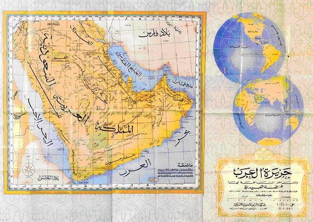
Saudi_map_of_Persian_gulf_-_1952.jpg (623 × 442 پکسل، فائل کا حجم: 81 کلوبائٹ، MIME قسم: image/jpeg)
| تفصیل |
English: Saudi Arabian Map of 1952 displaying the correct name for the Persian Gulf.
فارسی: نقشهٔ عربستان سعودی از خلیج فارس، مربوط به سال ۱۹۵۲ میلادی که نام درست خلیج فارس را نشان میدهد. |
||||||||||||||||||||||||
| تاریخ | |||||||||||||||||||||||||
| ماخذ | http://www.kavehfarrokh.com/wp-content/uploads/2009/02/map-of-persian-gulf-published-by-saudi-arabia-19523.jpg | ||||||||||||||||||||||||
| مصنف | The government of Saudi Arabia | ||||||||||||||||||||||||
| اجازت (فائل کا دوبارہ استعمال) |
|
||||||||||||||||||||||||

فائل کا تاریخچہ
کسی خاص وقت یا تاریخ میں یہ فائل کیسی نظر آتی تھی، اسے دیکھنے کے لیے اس وقت/تاریخ پر کلک کریں۔
| تاریخ/وقت | تھمب نیل | ابعاد | صارف | تبصرہ | |
|---|---|---|---|---|---|
| رائج الوقت | 18:22، 20 مارچ 2009ء | | 623 × 442 (81 کلوبائٹ) | David Trochos | |
| 09:02، 26 فروری 2009ء |  | 623 × 442 (81 کلوبائٹ) | Wayiran | {{Information |Description={{en|1=Saudi Arabian Map of 1952 displaying the correct name for the Persian Gulf.}} {{fa|1=نقشهٔ عربستان سعودی از خلیج فارس، مربوط به سال ۱۹۵۲ میلادی که نام درست خلیج |
روابط
درج ذیل 2 صفحات اس فائل کو استعمال کر رہے ہیں:
فائل کا عالمی استعمال
مندرجہ ذیل ویکیوں میں یہ فائل زیر استعمال ہے:
- ar.wikipedia.org پر استعمال
- ar.wikinews.org پر استعمال
- arz.wikipedia.org پر استعمال
- fa.wikipedia.org پر استعمال
- pnb.wikipedia.org پر استعمال
- tr.wikipedia.org پر استعمال