
فائل:ShepherdByzempire1265.jpg
اصل فائل (1,144 × 900 پکسل، فائل کا حجم: 281 کلوبائٹ، MIME قسم: image/jpeg)
خلاصہ
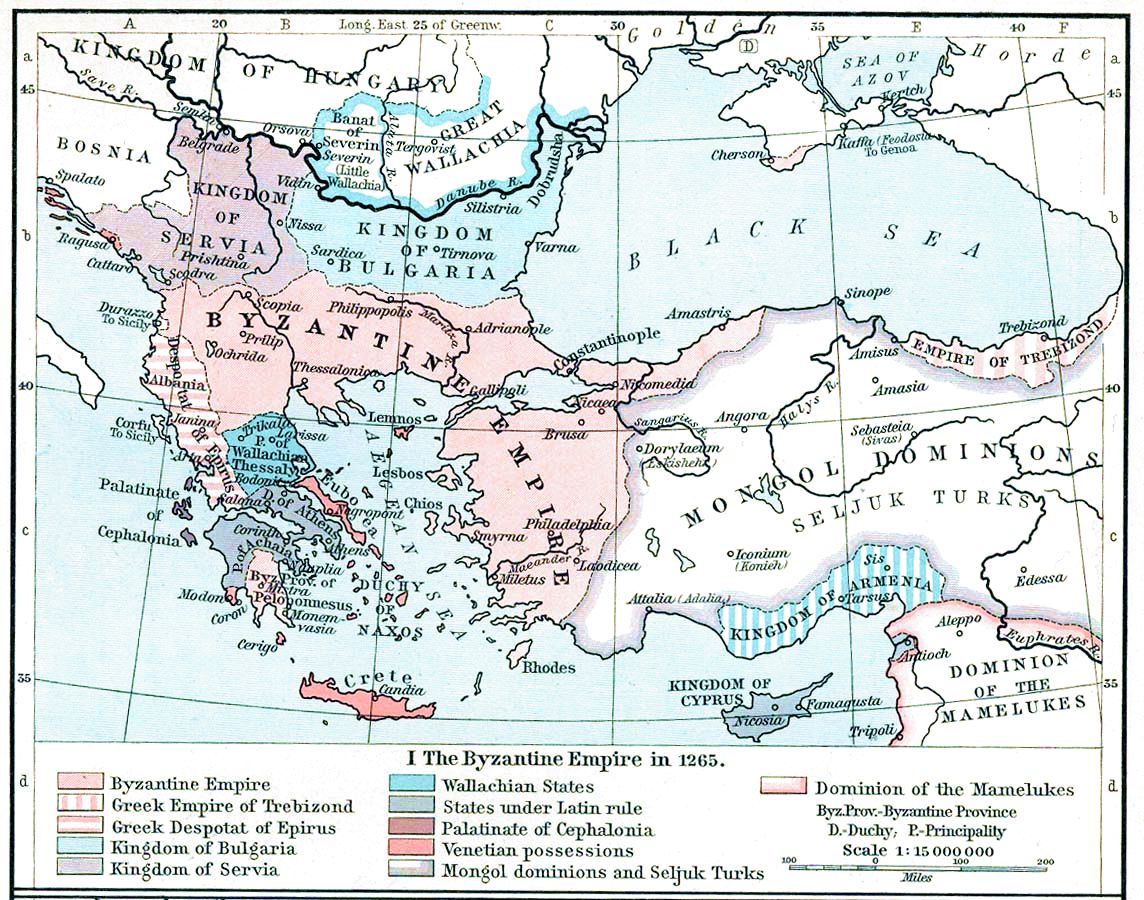
| تفصیل | Map, The Byzantine Empire, 1265. | ||||||||||||||||||||||
| تاریخ | |||||||||||||||||||||||
| ماخذ | The Historical Atlas, William R. Shepherd, 1911. | ||||||||||||||||||||||
| مصنف |
|
||||||||||||||||||||||
| دوسرے نسخے |
Derivative works of this file: |
||||||||||||||||||||||

|
This old map image could be re-created using vector graphics as an SVG file. This has several advantages; see Commons:Media for cleanup for more information. If an SVG form of this image is available, please upload it and afterwards replace this template with
{{vector version available|new image name}}.
It is recommended to name the SVG file “ShepherdByzempire1265.svg”—then the template Vector version available (or Vva) does not need the new image name parameter. |


اجازہ کاری
|
This work is in the public domain in its country of origin and other countries and areas where the copyright term is the author's life plus 70 years or fewer.
| |
| This file has been identified as being free of known restrictions under copyright law, including all related and neighboring rights. | |
This media file is in the public domain in the United States. This applies to U.S. works where the copyright has expired, often because its first publication occurred prior to January 1, 1929, and if not then due to lack of notice or renewal. See this page for further explanation.
|
 | |
 |
This image might not be in the public domain outside of the United States; this especially applies in the countries and areas that do not apply the rule of the shorter term for US works, such as Canada, Mainland China (not Hong Kong or Macao), Germany, Mexico, and Switzerland. The creator and year of publication are essential information and must be provided. See Wikipedia:Public domain and Wikipedia:Copyrights for more details.
|
فائل کا تاریخچہ
کسی خاص وقت یا تاریخ میں یہ فائل کیسی نظر آتی تھی، اسے دیکھنے کے لیے اس وقت/تاریخ پر کلک کریں۔
| تاریخ/وقت | تھمب نیل | ابعاد | صارف | تبصرہ | |
|---|---|---|---|---|---|
| رائج الوقت | 15:28، 16 نومبر 2022ء | | 1,144 × 900 (281 کلوبائٹ) | Gyalu22 | Reverted to version as of 16:26, 12 July 2009 (UTC) |
| 14:49، 20 مئی 2016ء |  | 1,144 × 900 (858 کلوبائٹ) | Julieta39 | Cosmetic (see discussion file) | |
| 16:26، 12 جولائی 2009ء |  | 1,144 × 900 (281 کلوبائٹ) | Alex:D | whitened | |
| 16:17، 12 جولائی 2009ء |  | 1,144 × 900 (281 کلوبائٹ) | Alex:D | whitened | |
| 16:12، 12 جولائی 2009ء |  | 1,144 × 900 (281 کلوبائٹ) | Alex:D | whitened | |
| 13:40، 21 دسمبر 2004ء |  | 1,144 × 900 (272 کلوبائٹ) | Mschlindwein | Map, The Byzantine Empire, 1265. The Historical Atlas, William R. Shepherd, 1911. |
روابط
درج ذیل صفحہ اس فائل کو استعمال کر رہا ہے:
فائل کا عالمی استعمال
مندرجہ ذیل ویکیوں میں یہ فائل زیر استعمال ہے:
- an.wikipedia.org پر استعمال
- ar.wikipedia.org پر استعمال
- azb.wikipedia.org پر استعمال
- az.wikipedia.org پر استعمال
- be-tarask.wikipedia.org پر استعمال
- be.wikipedia.org پر استعمال
- bg.wikipedia.org پر استعمال
- ca.wikipedia.org پر استعمال
- cs.wikipedia.org پر استعمال
- de.wikipedia.org پر استعمال
- el.wikipedia.org پر استعمال
- en.wikipedia.org پر استعمال
اس فائل کا مزید عالمی استعمال دیکھیے۔