
فائل:Tahoua Region departments.png

اصل فائل (1,056 × 816 پکسل، فائل کا حجم: 24 کلوبائٹ، MIME قسم: image/png)
| تفصیل |
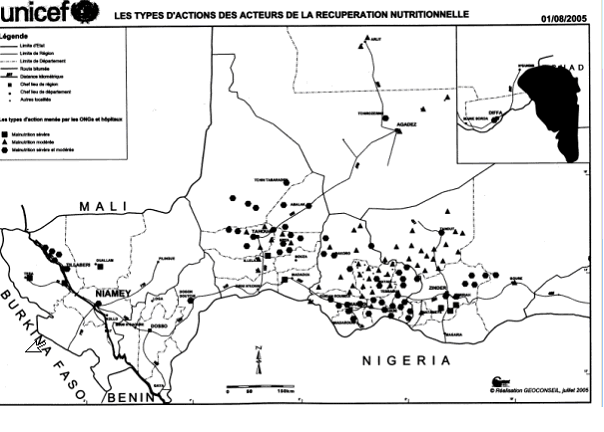
SummaryMap of the Departments of Tahoua Region, following the changes in administrative naming 1999-2005, with the addition of Abalak Department: a new subdivision created from the Tchin-tabaraden Department. Derived from Map of the arrondissements of Tahoua department in Niger. Created by Rarelibra 18:37, 13 September 2006 (UTC) for public domain use, using MapInfo Professional v8.5 and various mapping resources. See: fr:Tahoua (région) and en:Departments of Niger Image:Tahoua arrondissements.png http://www.senat.fr/rap/r04-512/r04-5128.gif Unicef Map http://www.fao.org/ag/agl/agll/wocat/wqasum.asp?questid=NIG05 FAO report http://www.fao.org/ag/agl/agll/wocat/img/qtnig7d.jpg FAO Map http://fr.wikipedia.org/wiki/Tahoua_%28r%C3%A9gion%29 Tahoua (région) * Département de Abalak Superficie: 77 445 km² (1) Population: 80 777 hts Centre urbaine: Ville d'Abalak |
| تاریخ | (UTC) |
| ماخذ | |
| مصنف |
|
| دوسرے نسخے |
|

| This is a retouched picture, which means that it has been digitally altered from its original version. Modifications: added subdivision. The original can be viewed here: Tahoua arrondissements.png: File:Tahoua arrondissements.png. Modifications made by T L Miles.
|
| میں اس تخلیقی کام کے حقوق کا مالک ہوں اور اسے دائرہ عام میں شائع کرتا ہوں جس کا اطلاق عالمی سطح پر ہوتا ہے۔ بعض ملکوں میں یہ قانونی طور پر شاید ممکن نہ ہو؛ اگر ایسا ہے تو: میں ہر ایک کو کسی بھی مقصد کے لیے بغیر کسی شرط کے اس تصویر کے استعمال کا حق تفویض کرتا/کرتی ہوں، بجز اس صورت کے جس میں کوئی قانونی رکاوٹ موجود ہو۔ |
اولین اپلوڈ کا نوشتہ
This image is a derivative work of the following images:
- Image:Tahoua_arrondissements.png licensed with PD-self
- 2006-11-10T12:48:31Z Béka 1056x816 (23579 Bytes) {{Information| |Description= == Summary == Map of the arrondissements of Tahoua department in Niger. Created by [[:en:User:Rarelibra|Rarelibra]] 18:37, 13 September 2006 (UTC) for public domain use, using MapInfo Professional
Uploaded with derivativeFX
فائل کا تاریخچہ
کسی خاص وقت یا تاریخ میں یہ فائل کیسی نظر آتی تھی، اسے دیکھنے کے لیے اس وقت/تاریخ پر کلک کریں۔
| تاریخ/وقت | تھمب نیل | ابعاد | صارف | تبصرہ | |
|---|---|---|---|---|---|
| رائج الوقت | 18:48، 19 جون 2008ء | | 1,056 × 816 (24 کلوبائٹ) | T L Miles | {{Information |Description=== Summary == Map of the Departments of Tahoua Region, following the changes in administrative naming 1999-2005, with the addition of Abalak Department: a new subdivision created from the Tchin-tabaraden Department. Derived f |
روابط
درج ذیل صفحہ اس فائل کو استعمال کر رہا ہے:
فائل کا عالمی استعمال
مندرجہ ذیل ویکیوں میں یہ فائل زیر استعمال ہے:
- da.wikipedia.org پر استعمال
- de.wikipedia.org پر استعمال
- en.wikipedia.org پر استعمال
- es.wikipedia.org پر استعمال
- fr.wikipedia.org پر استعمال
- ha.wikipedia.org پر استعمال
- ja.wikipedia.org پر استعمال
- lv.wikipedia.org پر استعمال
- pt.wikipedia.org پر استعمال
- ro.wikipedia.org پر استعمال
- ru.wikipedia.org پر استعمال
- tr.wikipedia.org پر استعمال
- www.wikidata.org پر استعمال
اس فائل کا مزید عالمی استعمال دیکھیے۔