
فائل:Woking Town Square - geograph.org.uk - 40908.jpg
اس سے زیادہ ریزولیوشن دستیاب نہیں۔
Woking_Town_Square_-_geograph.org.uk_-_40908.jpg (640 × 427 پکسل، فائل کا حجم: 85 کلوبائٹ، MIME قسم: image/jpeg)
خلاصہ
| تفصیل |
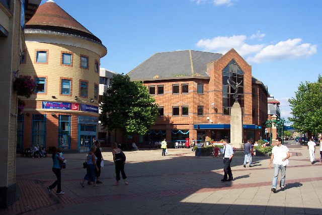
English: Woking Town Square. In 1838 when the railway arrived, Woking town centre was open heathland. The town developed in a fairly piecemeal fashion and had reached a form of completion by the mid-1980s, when redevelopment began again. A short-lived town centre swimming pool disappeared as part of those changes, to be replaced by the Pool in the Park. The present form of the town centre, including the modern library, the Peacocks shopping centre, and the refashioned Wolsey Way centre date from that time. |
| تاریخ | |
| ماخذ | From geograph.org.uk |
| مصنف | Ron Strutt |
| لگاؤ (required by the license) | Ron Strutt / Woking Town Square / |
| Object location | | View this and other nearby images on: OpenStreetMap |
|---|
_&language=ur)
اجازہ کاری

|
This image was taken from the Geograph project collection. See this photograph's page on the Geograph website for the photographer's contact details. The copyright on this image is owned by Ron Strutt and is licensed for reuse under the Creative Commons Attribution-ShareAlike 2.0 license.
|
This file is licensed under the Creative Commons Attribution-Share Alike 2.0 Generic license.
لگاؤ: Ron Strutt
- آپ آزاد ہیں:
- شیئر کرنے – کام کو نقل، تقسیم یا منتقل کرنے کے لیے
- ریمکس کے لیے – کام منبطق کرنے کے لیے
- مندرجہ ذیل شرائط کے تحت:
- انتساب – آپ کو اس کام کا انتساب مصنف یا اجازت دہندہ کے بتائے گئے طریقہ کے مطابق دینا ہوگا (تاہم یہ انتساب اس طرح نہیں ہونا چاہیے کہ اسے دیکھ کر ایسا محسوس ہو کہ اصل مصنف یا اجازت دہندہ آپ کے یا آپ کے ذریعہ اس کام کے استعمال کرنے کے حامی ہیں)۔
- یکساں شراکت – اگر آپ اس کام میں کوئی تبدیلی یا ترمیم کرتے ہیں یا اس کام پر مبنی کچھ نیا بناتے ہیں تو اسے بھی آپ اسی یا اس جیسے کسی اجازت نامے کے تحت شائع کر سکتے ہیں۔
- Remove redundant categories and try to put this image in the most specific category/categories
- Remove this template
- The location categories are based on information from this geonames tool and this OpenStreetMap tool combined with a database. You can also have a look at this tool from mysociety.
- The topic category from Geograph was Town centre (find similar images centre at Geograph)
فائل کا تاریخچہ
کسی خاص وقت یا تاریخ میں یہ فائل کیسی نظر آتی تھی، اسے دیکھنے کے لیے اس وقت/تاریخ پر کلک کریں۔
| تاریخ/وقت | تھمب نیل | ابعاد | صارف | تبصرہ | |
|---|---|---|---|---|---|
| رائج الوقت | 20:29، 30 جنوری 2010ء | | 640 × 427 (85 کلوبائٹ) | GeographBot | == {{int:filedesc}} == {{Information |description={{en|1=Woking Town Square. In 1838 when the railway arrived, Woking town centre was open heathland. The town developed in a fairly piecemeal fashion and had reached a form of completion by the mid-1980s, |
روابط
درج ذیل صفحہ اس فائل کو استعمال کر رہا ہے:
فائل کا عالمی استعمال
مندرجہ ذیل ویکیوں میں یہ فائل زیر استعمال ہے:
- af.wikipedia.org پر استعمال
- azb.wikipedia.org پر استعمال
- az.wikipedia.org پر استعمال
- ceb.wikipedia.org پر استعمال
- cs.wikipedia.org پر استعمال
- en.wikipedia.org پر استعمال
- fa.wikipedia.org پر استعمال
- fi.wikipedia.org پر استعمال
- hu.wikipedia.org پر استعمال
- ja.wikipedia.org پر استعمال
- ko.wikipedia.org پر استعمال
- lld.wikipedia.org پر استعمال
- nl.wikipedia.org پر استعمال
- nn.wikipedia.org پر استعمال
- no.wikipedia.org پر استعمال
- pl.wikipedia.org پر استعمال
- pl.wikivoyage.org پر استعمال
- simple.wikipedia.org پر استعمال
- sv.wikipedia.org پر استعمال
- szl.wikipedia.org پر استعمال
- zh.wikipedia.org پر استعمال