
فائل:French Algeria evolution 1830-1962 map-fr.svg

اس SVG فائل کی PNG نمائش کا حجم: 604 × 600 پکسلز دیگر تصمیمات: 242 × 240 پکسلز | 483 × 480 پکسلز | 773 × 768 پکسلز | 1,031 × 1,024 پکسلز | 2,062 × 2,048 پکسلز | 1,287 × 1,278 پکسلز۔
اصل فائل (ایس وی جی فائل، ابعاد 1,287 × 1,278 پکسل، فائل کا حجم: 1.86 MB)
خلاصہ
| تفصیل |
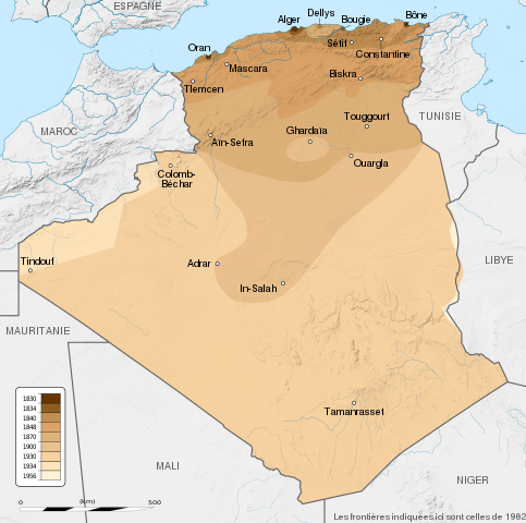
English: French Algeria evolution map, from 1830 to 1962.
Français : Carte montrant l'évolution territoriale de l'Algérie française, de 1830 à 1962.
|
| تاریخ | (UTC) |
| ماخذ |
English:
Français :
|
| مصنف | Sémhur |
| دوسرے نسخے |
Derivative works of this file: French Algeria evolution 1830-1962 map-es.svg |
| لگاؤ (required by the license) | © Sémhur / Wikimedia Commons / |
| SVG genesis |
| Camera location | | View this and other nearby images on: OpenStreetMap |
|---|
اجازہ کاری
میں اس کام کا کاپی رائٹ ہولڈر ہوں اور اسے مندرجہ ذیل اجازت ناموں کے تحت شائع کیا ہے:
| Copyleft: This work of art is free; you can redistribute it and/or modify it according to terms of the Free Art License. You will find a specimen of this license on the Copyleft Attitude site as well as on other sites. |
This file is licensed under the Creative Commons Attribution-Share Alike 4.0 International, 3.0 Unported, 2.5 Generic, 2.0 Generic and 1.0 Generic license.
- آپ آزاد ہیں:
- شیئر کرنے – کام کو نقل، تقسیم یا منتقل کرنے کے لیے
- ریمکس کے لیے – کام منبطق کرنے کے لیے
- مندرجہ ذیل شرائط کے تحت:
- انتساب – آپ کو اس کام کا انتساب مصنف یا اجازت دہندہ کے بتائے گئے طریقہ کے مطابق دینا ہوگا (تاہم یہ انتساب اس طرح نہیں ہونا چاہیے کہ اسے دیکھ کر ایسا محسوس ہو کہ اصل مصنف یا اجازت دہندہ آپ کے یا آپ کے ذریعہ اس کام کے استعمال کرنے کے حامی ہیں)۔
- یکساں شراکت – اگر آپ اس کام میں کوئی تبدیلی یا ترمیم کرتے ہیں یا اس کام پر مبنی کچھ نیا بناتے ہیں تو اسے بھی آپ اسی یا اس جیسے کسی اجازت نامے کے تحت شائع کر سکتے ہیں۔
آپ حسب منشا اجازت نامہ منتخب کر سکتے ہیں۔
اولین اپلوڈ کا نوشتہ
This image is a derivative work of the following images:
- File:Algeria_location_map.svg licensed with Cc-by-sa-3.0, GFDL
- 2009-11-17T12:51:26Z Sting 1287x1278 (372657 Bytes) == {{int:filedesc}} == {{Location|28|19|00|N|1|39|00|E|scale:8000000}} {{Information |Description={{en|Blank administrative map of [[:en:Algeria|Algeria]], for geo-location purposes.}} {{fr|Carte administrative vierge de l'[
Uploaded with derivativeFX
فائل کا تاریخچہ
کسی خاص وقت یا تاریخ میں یہ فائل کیسی نظر آتی تھی، اسے دیکھنے کے لیے اس وقت/تاریخ پر کلک کریں۔
| تاریخ/وقت | تھمب نیل | ابعاد | صارف | تبصرہ | |
|---|---|---|---|---|---|
| رائج الوقت | 19:34، 22 مئی 2014ء | | 1,287 × 1,278 (1.86 MB) | Sémhur | Valid SVG |
| 18:57، 29 ستمبر 2012ء |  | 1,287 × 1,278 (1.86 MB) | Sémhur | == {{int:filedesc}} == {{Information |Description={{Multilingual description |en= en:French Algeria evolution map, from 1830 to 1962. |fr= Carte de l'fr:Algérie française, de 1830 à 1962. }} <br/> Scale: 1:6,800,000 (precision: 1,700 m)... |
روابط
درج ذیل صفحہ اس فائل کو استعمال کر رہا ہے:
فائل کا عالمی استعمال
مندرجہ ذیل ویکیوں میں یہ فائل زیر استعمال ہے:
- ast.wikipedia.org پر استعمال
- bg.wikipedia.org پر استعمال
- ca.wikipedia.org پر استعمال
- da.wikipedia.org پر استعمال
- de.wikipedia.org پر استعمال
- en.wikipedia.org پر استعمال
- eu.wikipedia.org پر استعمال
- fa.wikipedia.org پر استعمال
- fi.wikipedia.org پر استعمال
- fr.wikipedia.org پر استعمال
- ga.wikipedia.org پر استعمال
- hy.wikipedia.org پر استعمال
- id.wikipedia.org پر استعمال
- it.wikipedia.org پر استعمال
- ja.wikipedia.org پر استعمال
- ka.wikipedia.org پر استعمال
- ko.wikipedia.org پر استعمال
- lt.wikipedia.org پر استعمال
- lv.wikipedia.org پر استعمال
- mk.wikipedia.org پر استعمال
- ms.wikipedia.org پر استعمال
- mt.wikipedia.org پر استعمال
- nl.wikipedia.org پر استعمال
- pl.wikipedia.org پر استعمال
- pnb.wikipedia.org پر استعمال
- pt.wikipedia.org پر استعمال
- ro.wikipedia.org پر استعمال
- ru.wikipedia.org پر استعمال
اس فائل کا مزید عالمی استعمال دیکھیے۔