
فائل:LakeKivu satellite.jpg
اس سے زیادہ ریزولیوشن دستیاب نہیں۔
LakeKivu_satellite.jpg (296 × 464 پکسل، فائل کا حجم: 21 کلوبائٹ، MIME قسم: image/jpeg)
خلاصہ
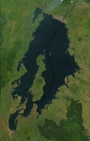
| تفصیل |
English: Lake Kivu, Africa, as seen from space. The black line marks the border between Rwanda and the Democratic Republic of the Congo. Cropped from a larger image (EAfrica.A2003033.0820.250m.jpg). |
| تاریخ | |
| ماخذ | "Fires in East Africa" - Visible Earth Image ID 4957 (details, image at 250m resolution) |
| مصنف | NASA |
اجازہ کاری
| This file is in the public domain in the United States because it was solely created by NASA. NASA copyright policy states that "NASA material is not protected by copyright unless noted". (See Template:PD-USGov, NASA copyright policy page or JPL Image Use Policy.) | ||
 |
Warnings:
|
اولین اپلوڈ کا نوشتہ
from en.wikipedia.org
- Uploaded on 23 February 2006 by en:User:Paphrag.
فائل کا تاریخچہ
کسی خاص وقت یا تاریخ میں یہ فائل کیسی نظر آتی تھی، اسے دیکھنے کے لیے اس وقت/تاریخ پر کلک کریں۔
| تاریخ/وقت | تھمب نیل | ابعاد | صارف | تبصرہ | |
|---|---|---|---|---|---|
| رائج الوقت | 14:19، 19 ستمبر 2010ء | | 296 × 464 (21 کلوبائٹ) | LobStoR | lossless crop from source NASA image at 250m resolution |
| 22:43، 24 مئی 2006ء |  | 295 × 476 (108 کلوبائٹ) | Dubhe | from en.wiki |
روابط
درج ذیل صفحہ اس فائل کو استعمال کر رہا ہے:
فائل کا عالمی استعمال
مندرجہ ذیل ویکیوں میں یہ فائل زیر استعمال ہے:
- af.wikipedia.org پر استعمال
- ar.wikipedia.org پر استعمال
- arz.wikipedia.org پر استعمال
- ast.wikipedia.org پر استعمال
- bn.wikipedia.org پر استعمال
- br.wikipedia.org پر استعمال
- ca.wikipedia.org پر استعمال
- ceb.wikipedia.org پر استعمال
- cs.wikipedia.org پر استعمال
- da.wikipedia.org پر استعمال
- de.wikipedia.org پر استعمال
- de.wikivoyage.org پر استعمال
- dsb.wikipedia.org پر استعمال
- el.wikipedia.org پر استعمال
- en.wikipedia.org پر استعمال
- eo.wikipedia.org پر استعمال
- es.wikipedia.org پر استعمال
- et.wikipedia.org پر استعمال
- eu.wikipedia.org پر استعمال
- fa.wikipedia.org پر استعمال
- fi.wikipedia.org پر استعمال
- fr.wikipedia.org پر استعمال
- fr.wikivoyage.org پر استعمال
- gl.wikipedia.org پر استعمال
- he.wikipedia.org پر استعمال
- hsb.wikipedia.org پر استعمال
- hy.wikipedia.org پر استعمال
- ig.wikipedia.org پر استعمال
- it.wikipedia.org پر استعمال
- ja.wikipedia.org پر استعمال
- ka.wikipedia.org پر استعمال
- ko.wikipedia.org پر استعمال
اس فائل کا مزید عالمی استعمال دیکھیے۔