
فائل:Percentage population undernourished world map.PNG

اس نمائش کا حجم: 800 × 362 پکسلز۔ دیگر تصمیمات: 320 × 145 پکسلز | 640 × 289 پکسلز | 1,237 × 559 پکسلز۔
اصل فائل (1,237 × 559 پکسل، فائل کا حجم: 161 کلوبائٹ، MIME قسم: image/png)
خلاصہ
| تفصیل |
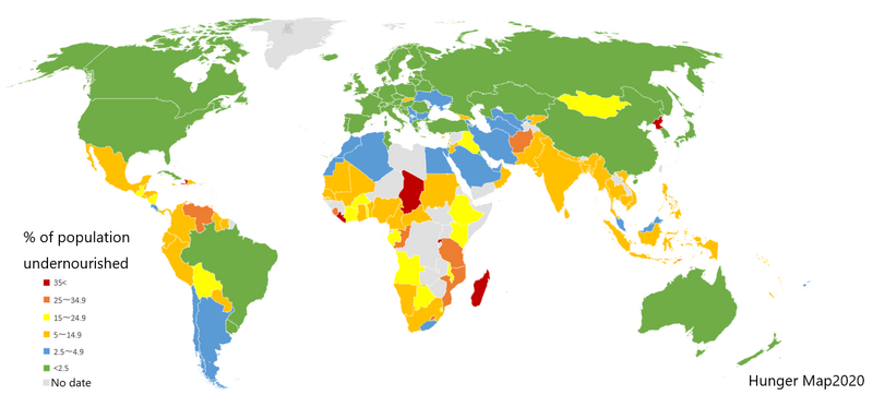
English: List of countries by percentage of population suffering from undernourishment. Made by jp:User:Fnweirkmnwperojvnu, using Map of Excel. The map has been updated (on 2021-01-11) according to the "Hunger Map 2020" from the United Nations World Food Programme.
Sources: Sustainable Development Goal indicators website "Global SDG Indicators Database>GOLE2 End hunger, achieve food security and improved nutrition and promote sustainable agriculture": https://unstats.un.org/sdgs/indicators/database/?indicator=2.1.1 United Nations World Food Programme's interactive "hunger map": http://cdn.wfp.org/hungermap/ Hunger Map 2020: https://www.wfp.org/publications/hunger-map-2020 |
| تاریخ | 11 جنوری 2021 (original upload date) |
| ماخذ | Transferred from en.wikipedia to Commons. |
| مصنف | The original uploader was Fnweirkmnwperojvnu at jp ویکیپیڈیا. |
| دوسرے نسخے |
Derivative works of this file: Percentage population undernourished world map-ar.PNG  |


|
This map image could be re-created using vector graphics as an SVG file. This has several advantages; see Commons:Media for cleanup for more information. If an SVG form of this image is available, please upload it and afterwards replace this template with
{{vector version available|new image name}}.
It is recommended to name the SVG file “Percentage population undernourished world map.svg”—then the template Vector version available (or Vva) does not need the new image name parameter. |
اجازہ کاری

|
آپ کو آزاد سافٹ ویئر فاؤنڈیشن کی جانب سے شائع کردہ جی این یو آزاد مسوداتی اجازت نامہ کی شرائط استعمال کے تحت اس دستاویز کو نقل، تقسیم اور/ یا ترمیم کرنے کی اجازت دی جاتی ہے۔ اس اجازت نامہ کی ایک نقل 'جی این یو آزاد مسوداتی اجازت نامہ کے عنوان سے میسر ہے۔ |
| اس ملف کا لائسنس Creative Commons Attribution-Share Alike 3.0 Unported کے تحط ہے۔ | ||
| ||
| This licensing tag was added to this file as part of the GFDL licensing update. |
اولین اپلوڈ کا نوشتہ
فائل کی تفصیلات کا اصل صفحہ یہاں تھا۔ درج ذیل تمام صارفین en.wikipedia کے ہیں۔
- 2007-03-23 02:31 Lobizón 1355×768×8 (58226 bytes) List of countries by percentage of population suffering from undernourishment. Made from Wikipedia's "map of the world" template, using information from the United Nations World Food Programme and the FAO "The State of Food Insecurity in the World 2006" r
فائل کا تاریخچہ
کسی خاص وقت یا تاریخ میں یہ فائل کیسی نظر آتی تھی، اسے دیکھنے کے لیے اس وقت/تاریخ پر کلک کریں۔
| تاریخ/وقت | تھمب نیل | ابعاد | صارف | تبصرہ | |
|---|---|---|---|---|---|
| رائج الوقت | 16:31، 10 جنوری 2021ء | | 1,237 × 559 (161 کلوبائٹ) | Fnweirkmnwperojvnu | data updates |
| 21:07، 18 جولائی 2020ء |  | 1,357 × 628 (47 کلوبائٹ) | Maphobbyist | South Sudan border | |
| 18:30، 16 اپریل 2016ء |  | 1,357 × 628 (46 کلوبائٹ) | Kontrollstellekundl | updated according to the "Hunger Map 2013" http://documents.wfp.org/stellent/groups/public/documents/communications/wfp229327.pdf | |
| 12:20، 28 فروری 2016ء |  | 1,357 × 628 (45 کلوبائٹ) | Kontrollstellekundl | cropped | |
| 14:08، 15 اگست 2015ء |  | 1,355 × 768 (46 کلوبائٹ) | Jamie Tubers | update | |
| 04:38، 31 دسمبر 2013ء |  | 1,355 × 768 (56 کلوبائٹ) | Varitia | Small correction on Indonesia | |
| 04:19، 31 دسمبر 2013ء |  | 1,355 × 768 (56 کلوبائٹ) | Varitia | Update to 2012 figures and parameters according to the United Nations World Food Programme | |
| 23:04، 4 مئی 2008ء |  | 1,355 × 768 (56 کلوبائٹ) | Dwrcan | Updates. (Note: click on the actual countries of the source map, the actual data sometimes doesn't match the color of the country.) | |
| 21:00، 10 نومبر 2007ء |  | 1,355 × 768 (57 کلوبائٹ) | Béka~commonswiki | {{Information |Description={{en|List of countries by percentile of population suffering from undernourishment. Made by en:User:Lobizón, using Wikipedia's "map of the world" template, and information from the United Nations World Food Programme and t |
روابط
درج ذیل 2 صفحات اس فائل کو استعمال کر رہے ہیں:
فائل کا عالمی استعمال
مندرجہ ذیل ویکیوں میں یہ فائل زیر استعمال ہے:
- af.wikipedia.org پر استعمال
- ast.wikipedia.org پر استعمال
- ba.wikipedia.org پر استعمال
- bg.wikipedia.org پر استعمال
- bn.wikipedia.org پر استعمال
- cs.wikipedia.org پر استعمال
- cv.wikipedia.org پر استعمال
- de.wikipedia.org پر استعمال
- en.wikipedia.org پر استعمال
- en.wikinews.org پر استعمال
- eo.wikipedia.org پر استعمال
- es.wikipedia.org پر استعمال
- es.wikinews.org پر استعمال
- eu.wikipedia.org پر استعمال
- fa.wikipedia.org پر استعمال
- fi.wikipedia.org پر استعمال
- fy.wikipedia.org پر استعمال
- gu.wikipedia.org پر استعمال
- he.wikipedia.org پر استعمال
- hr.wikipedia.org پر استعمال
- hu.wikipedia.org پر استعمال
- hy.wikipedia.org پر استعمال
- id.wikipedia.org پر استعمال
- is.wikipedia.org پر استعمال
- it.wikipedia.org پر استعمال
- ja.wikipedia.org پر استعمال
- kn.wikipedia.org پر استعمال
- la.wikipedia.org پر استعمال
- lmo.wikipedia.org پر استعمال
- lt.wikipedia.org پر استعمال
اس فائل کا مزید عالمی استعمال دیکھیے۔