
فائل:Sassanid-empire.gif
Sassanid-empire.gif (600 × 480 پکسل، فائل کا حجم: 101 کلوبائٹ، MIME قسم: image/gif)
خلاصہ
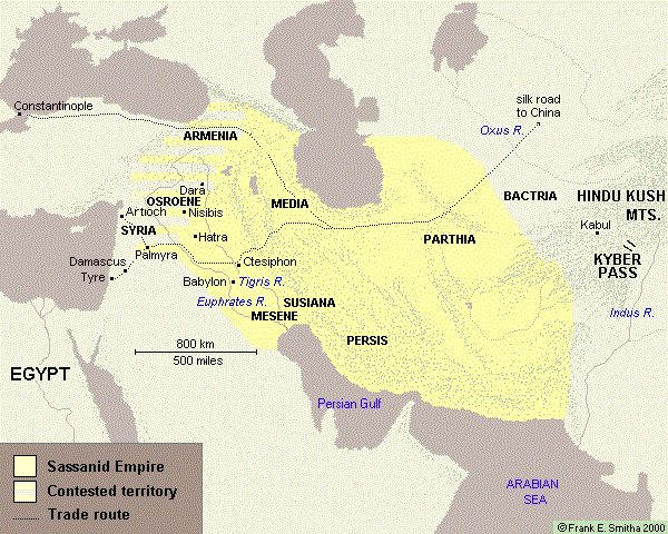
The normal borders of the great Sassanid Empire during much of its existence. (Map by Frank Smitha used by permission granted on December 15, 2006 by his agent, Marilynn Bell.)
اجازہ کاری

|
The copyright holder of this work allows anyone to use it for any purpose including unrestricted redistribution, commercial use, and modification.
Usage notes:
|
Atlas
This map should be added to the Wikimedia Atlas.
فائل کا تاریخچہ
کسی خاص وقت یا تاریخ میں یہ فائل کیسی نظر آتی تھی، اسے دیکھنے کے لیے اس وقت/تاریخ پر کلک کریں۔
| تاریخ/وقت | تھمب نیل | ابعاد | صارف | تبصرہ | |
|---|---|---|---|---|---|
| رائج الوقت | 07:50، 14 جون 2017ء | | 600 × 480 (101 کلوبائٹ) | Babak2000ir | The label: Persian Gulf is added. For the better historical context and more accuracy. |
| 07:48، 14 جون 2017ء |  | 600 × 480 (21 کلوبائٹ) | Babak2000ir | Reverted to version as of 23:13, 15 December 2006 (UTC) | |
| 07:46، 14 جون 2017ء |  | 600 × 480 (101 کلوبائٹ) | Babak2000ir | The label: Persian Gulf is added. For the better historical context and more accuracy. | |
| 23:13، 15 دسمبر 2006ء |  | 600 × 480 (21 کلوبائٹ) | Larry Dunn | The normal borders of the great Sassanid Empire during much of its existence. |
روابط
اس فائل سے مربوط کوئی صفحہ موجود نہیں ہے۔
فائل کا عالمی استعمال
مندرجہ ذیل ویکیوں میں یہ فائل زیر استعمال ہے:
- azb.wikipedia.org پر استعمال
- el.wikipedia.org پر استعمال
- en.wikipedia.org پر استعمال
- fa.wikipedia.org پر استعمال
- fr.wikipedia.org پر استعمال
- he.wikipedia.org پر استعمال
- it.wikipedia.org پر استعمال
- ka.wikipedia.org پر استعمال
- tr.wikipedia.org پر استعمال
- uk.wikipedia.org پر استعمال