جزائر سپراٹلی
| متنازع جزیرہ(جزائر) | |
|---|---|

| |
| جزائر سپراٹلی | |
| جغرافیہ | |
| مقام | بحیرہ جنوبی چین |
| متناسقات | 10°N 114°E / 10°N 114°E |
| کل جزائر | >750 جزائر |
| اہم جزائر | Itu Aba Island Thitu Island |
| رقبہ | ~4 km2 (1.5 mi2) |
| خط ساحل | 926 km (575 mi) |
| بلند ترین نقطہ | Southwest Cay 4 metres (13 ft) |
| دعوی | |
| برونائی زون | برونائی زون |
| پریفیکچر سطح شہر | سانشا, ہائنان[3] |
| ریاست | صباح |
| بلدیہ | کالایان |
| بلدیہ | کائوسیونگ |
| ضلع | تروونگ سا |
| آبادیات | |
| آبادی | No indigenous peoples |
| نسلی گروہ | Various ethnicities |
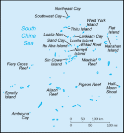
جزائر سپراٹلی (Spratly Islands) (چینی: Nansha islands, فیلپینو: Kapuluan ng Kalayaan,[4] مالے: Kepulauan Spratly اور ویتنامی: Quần đảo Trường Sa) بحیرہ جنوبی چین میں 750 سے زیادہ متنازع جزائر کا مجموعہ ہے۔[5] یہ مجموعہ الجزائر فلپائن، ملائیشیا (صباح) اور جنوبی ویتنام کے ساحلوں کے قریب واقع ہے۔
حوالہ جات[ترمیم]
- ↑ With reclaimed land, Swallow Reef was probably the third largest "island" in the Spratlys. Reclamation activities by the PRC in 2014 have added significant land areas to a number of submerged reefs and atolls like Johnson South Reef, Fiery Cross Reef and the Gaven Reefs.
- ↑ See List of maritime features in the Spratly Islands for information about individual islands.
- ↑ 民政部关于国务院批准设立地级三沙市的公告-中华人民共和国民政部 آرکائیو شدہ (Date missing) بذریعہ mca.gov.cn (Error: unknown archive URL), Ministry of Civil Affairs of the PRC - Totally useless reference for readers of English wikipedia; No indication of what it's about, or why it's being quoted.
- ↑ Redempto Anda (17 July 2012)۔ "Government told of China buildup 2 months ago"۔ Philippine Inquirer۔ 25 دسمبر 2018 میں اصل سے آرکائیو شدہ۔ اخذ شدہ بتاریخ 29 اکتوبر 2013
- ↑ "South China Sea Islands". Terrestrial Ecoregions. World Wildlife Fund.
زمرہ جات:
- جزائر سپراٹلی
- ایشیا کے متنازع علاقے
- ایشیاء کے متنازع علاقے
- بحر الکاہل کے مجمع الجزائر
- بحر الکاہل کے مجموعات الجزائر
- بحیرہ جنوبی چین کے جزائر
- برونائی کے جزائر
- برونائی کے علاقائی تنازعات
- تائیوان کے مجمع الجزائر
- جمہوریہ چین کے علاقائی تنازعات
- جنوب مشرقی ایشیاء کے مجموعہ الجزائر
- چین کے مجمع الجزائر
- عوامی جمہوریہ چین کے علاقائی تنازعات
- فلپائن کے علاقائی تنازعات
- فلپائن کے مجمع الجزائر
- فلپائن کے مجموعہ الجزائر
- متنازع جزائر
- ملائشیا کے علاقائی تنازعات
- ملائیشیا کے جزائر
- ویتنام کے علاقائی تنازعات
- ویتنام کے مجمع الجزائر
- ہائنان کے جزائر
- ٹائٹل اسٹائل میں بیک گراؤنڈ اور ٹیکسٹ الائن دونوں کے ساتھ ٹوٹنے والی فہرست کا استعمال کرنے والے صفحات
