"گولان پہاڑیاں" کے نسخوں کے درمیان فرق
حذف شدہ مندرجات اضافہ شدہ مندرجات
م روبالہ مساوی زمرہ جات (22): + زمرہ:شام کے علاقائی تنازعات |
م clean up, replaced: ← (117), ← (30), ← (25) using AWB |
||
| سطر 3: | سطر 3: | ||
<!--See the Table at Infobox Municipality for all fields and descriptions of usage--> |
<!--See the Table at Infobox Municipality for all fields and descriptions of usage--> |
||
<!-- Basic info ----------------> |
<!-- Basic info ----------------> |
||
|name |
|name = سطح مرتفع گولان<br />Golan Heights <!-- at least one of the first two fields must be filled in --> |
||
|official_name |
|official_name = |
||
|other_name |
|other_name = |
||
|native_name |
|native_name = هضبة الجولان<br/>רמת הגולן<!-- if different from the English name --> |
||
|nickname |
|nickname = |
||
|settlement_type |
|settlement_type = |
||
|total_type |
|total_type = <!-- to set a non-standard label for total area and population rows --> |
||
<!-- images and maps -----------> |
<!-- images and maps -----------> |
||
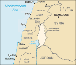
|image_map = Golan_Heights_Map.PNG |
|image_map = Golan_Heights_Map.PNG |
||
|image_skyline |
|image_skyline = Brechat ram mt hermon.JPG |
||
|image_caption = [[جھیل مسعدہ]] نزد [[کوہ حرمون]] (پس منظر), شمال مشرقی سطح مرتفع گولان |
|image_caption = [[جھیل مسعدہ]] نزد [[کوہ حرمون]] (پس منظر), شمال مشرقی سطح مرتفع گولان |
||
|mapsize |
|mapsize = |
||
|dot_x = |dot_y = |
|dot_x = |dot_y = |
||
|pushpin_map |
|pushpin_map = <!-- name of a location map as per Template:Location_map --> |
||
|pushpin_label_position = <!-- position of the pushpin label: left, right, top, bottom, none --> |
|pushpin_label_position = <!-- position of the pushpin label: left, right, top, bottom, none --> |
||
|pushpin_map_caption |
|pushpin_map_caption = |
||
|pushpin_mapsize |
|pushpin_mapsize = |
||
|coordinates_display |
|coordinates_display = inline,title |
||
|coordinates_type |
|coordinates_type = dim:80km |
||
|latd=32 |latm=58 |lats=54 |latNS=N |
|latd=32 |latm=58 |lats=54 |latNS=N |
||
|longd=35 |longm=44 |longs=58 |longEW=E |
|longd=35 |longm=44 |longs=58 |longEW=E |
||
|subdivision_type |
|subdivision_type = ملک |
||
|subdivision_name |
|subdivision_name = اسرائیل کی طرف سے قبضہ شامی علاقہ.<ref name=BBC>{{cite web|title=Golan Heights profile|url=http://www.bbc.co.uk/news/world-middle-east-14724842|work=BBC|accessdate=30 November 2011}}</ref> |
||
|subdivision_type1 |
|subdivision_type1 = |
||
|subdivision_name1 |
|subdivision_name1 = |
||
|seat_type |
|seat_type = |
||
|seat |
|seat = |
||
|parts_type |
|parts_type = |
||
|parts_style |
|parts_style = <!-- =list (for list), coll (for collapsed list), para (for paragraph format) |
||
Default is list if up to 5 items, coll if more than 5--> |
|||
|parts |
|parts = <!-- parts text, or header for parts list --> |
||
|p1 |
|p1 = |
||
|p2 |
|p2 = <!-- etc. up to p50: for separate parts to be listed--> |
||
<!-- Area |
<!-- Area ---------------------> |
||
|area_magnitude |
|area_magnitude = <!-- use only to set a special wikilink --> |
||
|unit_pref |
|unit_pref =<!--Enter: Imperial, to display imperial before metric--> |
||
|area_footnotes |
|area_footnotes = |
||
|area_total_km2 |
|area_total_km2 =1800 <!-- ALL fields with measurements are subject to automatic unit conversion--> |
||
|area_blank1_title |
|area_blank1_title =[[اسرائیل]] کا قبضہ |
||
|area_blank1_km2 |
|area_blank1_km2 =1200 |
||
<!-- Elevation --------------------------> |
<!-- Elevation --------------------------> |
||
|elevation_footnotes |
|elevation_footnotes = <!--for references: use <ref> </ref> tags--> |
||
|elevation_m |
|elevation_m = |
||
|elevation_max_m |
|elevation_max_m =2814 |
||
|elevation_min_m |
|elevation_min_m =0 |
||
<!-- Population |
<!-- Population -----------------------> |
||
|population_as_of |
|population_as_of =2011 |
||
|population_total |
|population_total = |
||
|population_footnotes |
|population_footnotes = |
||
}} |
}} |
||
نسخہ بمطابق 08:07، 22 نومبر 2015ء
هضبة الجولان רמת הגולן | |
|---|---|
 جھیل مسعدہ نزد کوہ حرمون (پس منظر), شمال مشرقی سطح مرتفع گولان | |
 | |
| ملک | اسرائیل کی طرف سے قبضہ شامی علاقہ.[1] |
| رقبہ | |
| • کل | 1,800 کلومیٹر2 (700 میل مربع) |
| • اسرائیل کا قبضہ | 1,200 کلومیٹر2 (500 میل مربع) |
| بلند ترین پیمائش | 2,814 میل (9,232 فٹ) |
| پست ترین پیمائش | 0 میل (0 فٹ) |
مرتفع جولان ، جسکو عربی میں ھضبۃ الجولان کہا جاتا ہے ایک سطح مرتفع (plateau) علاقہ ہے اور ارض شام کا حصہ ہوتے ہوۓ اس ملک کے مغرب میں واقع ہے۔ جغرافیائی لحاظ سے ھضبۃ الجولان کے گرد جو دیگر علاقے پاۓ جاتے ہیں ان میں لبنان ، اردن اور اسرائیل شامل ہیں۔ اسکو اردو میں اکثر ، انگریزی حساب سے صرف گولان بھی لکھ دیا جاتا ہے اور اسی زبان میں اسکو Golan Heights بھی کہا جاتا ہے۔
حوالہ جات
- ↑ "Golan Heights profile"۔ BBC۔ اخذ شدہ بتاریخ 30 نومبر 2011
