"ضلع شمالی وزیرستان" کے نسخوں کے درمیان فرق
حذف شدہ مندرجات اضافہ شدہ مندرجات
Addbot (تبادلۂ خیال | شراکتیں) م روبالہ: منتقلی 15 بین الویکی روابط، اب ویکی ڈیٹا میں d:q1915545 پر موجود ہیں |
کوئی خلاصۂ ترمیم نہیں |
||
| سطر 1: | سطر 1: | ||
{{Infobox settlement |
{{Infobox settlement |
||
<!-- See Template:Infobox settlement for additional fields and descriptions --> |
<!-- See Template:Infobox settlement for additional fields and descriptions --> |
||
| name = |
| name = شمالی وزیرستان |
||
| native_name = |
| native_name = |
||
| native_name_lang = ur<!-- ISO 639-2 code e.g. "ur" for Urdu. --> |
| native_name_lang = ur<!-- ISO 639-2 code e.g. "ur" for Urdu. --> |
||
| settlement_type = |
| settlement_type = ایجنسی<!-- such as Town, Village, City, Borough etc. --> |
||
<!-- images ---> |
<!-- images ---> |
||
| image_skyline = |
| image_skyline = |
||
| سطر 13: | سطر 13: | ||
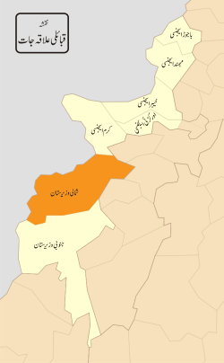
| image_map = FATA Dist North Wazir.svg |
| image_map = FATA Dist North Wazir.svg |
||
| map_alt = |
| map_alt = |
||
| map_caption = قبائلی علاقہ جات |
|||
| map_caption = District map of FATA and Khyber-Pakhtunkhwa - Districts of FATA are shown shown in blue, Waziristan is located in the south. |
|||
| latd = |latm = |lats = |latNS = |
| latd = |latm = |lats = |latNS = |
||
| longd = |longm = |longs = |longEW = |
| longd = |longm = |longs = |longEW = |
||
| سطر 19: | سطر 19: | ||
| coordinates_display = inline,title |
| coordinates_display = inline,title |
||
<!-- location ------------------> |
<!-- location ------------------> |
||
| subdivision_type = |
| subdivision_type = ملک |
||
| subdivision_name = |
| subdivision_name = پاکستان<!-- the name of the country --> |
||
<!-- established ---------------> |
<!-- established ---------------> |
||
| established_title = |
| established_title = قیام |
||
| established_date = 1910 |
| established_date = 1910 |
||
<!-- seat, smaller parts -------> |
<!-- seat, smaller parts -------> |
||
| seat_type = |
| seat_type = ہیڈکوارٹر |
||
| seat = [[ |
| seat = [[میران شاہ]] |
||
| parts_type = |
| parts_type = تحصیل |
||
| parts_style = para |
| parts_style = para |
||
| p1 = |
| p1 = |
||
| سطر 34: | سطر 34: | ||
| government_footnotes = <!-- for references: use <ref> tags --> |
| government_footnotes = <!-- for references: use <ref> tags --> |
||
| government_type = |
| government_type = |
||
| leader_title = |
| leader_title = پولیٹیکل ایجنٹ |
||
| leader_name = |
| leader_name = محمد یحیی |
||
<!-- area ----------------------> |
<!-- area ----------------------> |
||
| area_footnotes = <!-- for references: use <ref> tags --> |
| area_footnotes = <!-- for references: use <ref> tags --> |
||
| area_total_km2 = |
| area_total_km2 = 4707 |
||
<!-- elevation -----------------> |
<!-- elevation -----------------> |
||
| elevation_footnotes = <!-- for references: use <ref> tags --> |
| elevation_footnotes = <!-- for references: use <ref> tags --> |
||
| سطر 48: | سطر 48: | ||
<!-- population ----------------> |
<!-- population ----------------> |
||
| population_footnotes = <!-- for references: use <ref> tags --> |
| population_footnotes = <!-- for references: use <ref> tags --> |
||
| population_total = |
| population_total = 361246 |
||
| population_as_of = 1998 |
| population_as_of = 1998 |
||
| population_density_km2 = auto |
| population_density_km2 = auto |
||
<!-- time zone(s) --------------> |
<!-- time zone(s) --------------> |
||
| timezone1 = [[پاکستان کا معیاری وقت |
| timezone1 = [[پاکستان کا معیاری وقت]] |
||
| utc_offset1 = +5 |
| utc_offset1 = +5 |
||
<!-- postal codes, area code ---> |
<!-- postal codes, area code ---> |
||
| سطر 59: | سطر 59: | ||
| iso_code = |
| iso_code = |
||
<!-- twin cities ---------------> |
<!-- twin cities ---------------> |
||
| blank_name_sec1 = |
| blank_name_sec1 = اہم زبان (زبانیں) |
||
| blank_info_sec1 = [[ |
| blank_info_sec1 = [[پشتو|پشتو]], [[پاکستانی انگریزی|انگریزی]] |
||
<!-- website, footnotes --------> |
<!-- website, footnotes --------> |
||
| website = |
| website = |
||
نسخہ بمطابق 06:46، 9 جولائی 2013ء
| ایجنسی | |
 قبائلی علاقہ جات | |
| ملک | پاکستان |
| قیام | 1910 |
| ہیڈکوارٹر | میران شاہ |
| حکومت | |
| • پولیٹیکل ایجنٹ | محمد یحیی |
| رقبہ | |
| • کل | 4,707 کلومیٹر2 (1,817 میل مربع) |
| آبادی (1998) | |
| • کل | 361,246 |
| • کثافت | 77/کلومیٹر2 (200/میل مربع) |
| منطقۂ وقت | پاکستان کا معیاری وقت (UTC+5) |
| اہم زبان (زبانیں) | پشتو, انگریزی |
شمالی وزیرستان پاکستان کا ایک قبائلی علاقہ ہے جس کو شمالی وزیرستان ایجنسی بھی کہا جاتا ہے.جوکہ بنوں کے سنگم پر واقع ھے۔ اس کا صدرمقام میران شاہ ہے .

