فائل:Europe map 1648.PNG
صفحے کے مندرجات دوسری زبانوں میں قابل قبول نہیں ہیں۔
آزاد دائرۃ المعارف، ویکیپیڈیا سے

اصل فائل(1,894 × 1,367 پکسل، فائل کا حجم: 195 کلوبائٹ، MIME قسم: image/png)

یہ فائل ویکی ذخائر کی ہے اور دیگر منصوبوں کے زیر استعمال ہوسکتی ہے۔ فائل کے صفحہ تعارف پر موجود تعارف ذیل میں موجود ہے۔

This historical map image could be re-created using vector graphics as an SVG file. This has several advantages; see Commons:Media for cleanup for more information. If an SVG form of this image is available, please upload it and afterwards replace this template with {{vector version available|new image name}}.


It is recommended to name the SVG file “Europe map 1648.svg”—then the template Vector version available (or Vva) does not need the new image name parameter.

خلاصہ

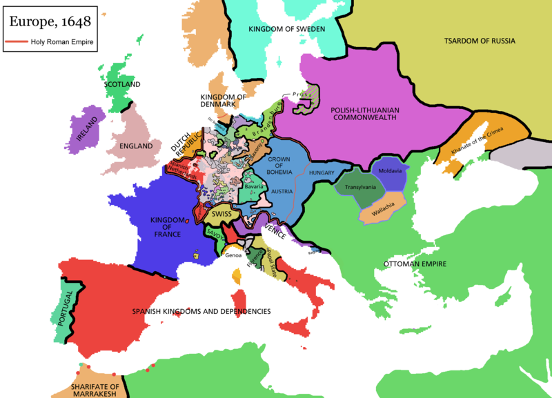
Map of Europe in 1648 (at the end of the Thirty Years War), based on free map of europe Image:BlankMap-Europe.png. Red line marks the border of the Holy Roman Empire. Information from Penguin atlas of modern history. (what year?)

Maps of the history of Europe
BCE
aC

Weichselian ice age (c. 113,000–9700) · Neolithic expansion (c. 7000–4500) · Middle Neolithic (c. 4500–4000) · Late Neolithic (c. 4000–3000) · Copper Age – Corded Ware culture (c. 2900–2350) · Copper Age – Bellbeaker culture (c. 2800–1800) · Early Bronze Age – Unetice culture (c. 2300–1600) · Late Bronze Age – Urnfield culture (c. 1300—750) · Migrations (c. 1000–100) · Hallstatt & La Tène cultures (c. 800–100) · Roman Republic (510–40) · 220 · 218 · 200 · 201–100 · 58 · 49 · 39 · 30 BCE–6 CE


CE
dC

14 · 14–37 · 60 · 60 · 69 · 80 · Migrations 100–500 · 117 · 117 · 125 · Migrations 150–774 · Economy 180 · 271 · 293–305 · 337 · 395 · c. 395 · 400 · 400 · 450 · 457–61 · 476 · 480 · Franks 481–814 · Early Slavs 500–700 · 500 · 526 · 526–600 · Christianisation to 600 · c. 550 · 650 · Pontic Steppe 650 · 665 · 800 · Vikings 800–1050 · 814 · 843–70 · 850 · 900 · 912 · 998 · 1000 · 1000 · 1054 · 1092 · First Crusade 1095–99 · 1097 · 1135 · 1142 · 1147–49 · 1190 · 1190 · 1250 · c. 1250 · 1301-1400 · 1301-1400 · 1328 · 1345 · Black Plague 1347–51 · 1360 · 1400 · Trade routes c. 1400 · 1430 · 1470 · 1490 · 1492 · 1500 · 1519 · 1550 · 1560 · Religion 1560 · Religion 1600 · Religion 1618 · 1618–48 · 1648 · 1683 · 1700 · 1701 · 1708 · 1714 · 1721 · 1725–30 · 1739–1740 · 1740 · 1748–66 · 1783–1792 · 1787 · 1787 · 1789 · 1799 · 1812 · 1812 · 1812 · 1812 · 1813 · 1815 · 1815 · 1815 · 1818 · Ottoman Empire 1830–1923 · 1848–49 · 1861 · 1867 · 1871 · 1878 · 1890 · 1905 · 1911 · 1914 · 1914 · 1919 · 1919–29 · 1923 · 1929 · 1930 · 1940 · 1941–42 · 1942–45 · Cold War 1947–91 · 1950 · 1993–2006 · 2006 to date

(this template: · view · discuss )


اجازہ کاری

GNU head آپ کو آزاد سافٹ ویئر فاؤنڈیشن کی جانب سے شائع کردہ جی این یو آزاد مسوداتی اجازت نامہ کی شرائط استعمال کے تحت اس دستاویز کو نقل، تقسیم اور/ یا ترمیم کرنے کی اجازت دی جاتی ہے۔ اس اجازت نامہ کی ایک نقل 'جی این یو آزاد مسوداتی اجازت نامہ کے عنوان سے میسر ہے۔
w:en:Creative Commons
انتساب یکساں شراکت
اس ملف کا لائسنس Creative Commons Attribution-Share Alike 3.0 Unported کے تحط ہے۔
آپ آزاد ہیں:
  • شیئر کرنے – کام کو نقل، تقسیم یا منتقل کرنے کے لیے
  • ریمکس کے لیے – کام منبطق کرنے کے لیے
مندرجہ ذیل شرائط کے تحت:
  • انتساب – آپ کو اس کام کا انتساب مصنف یا اجازت دہندہ کے بتائے گئے طریقہ کے مطابق دینا ہوگا (تاہم یہ انتساب اس طرح نہیں ہونا چاہیے کہ اسے دیکھ کر ایسا محسوس ہو کہ اصل مصنف یا اجازت دہندہ آپ کے یا آپ کے ذریعہ اس کام کے استعمال کرنے کے حامی ہیں)۔
  • یکساں شراکت – اگر آپ اس کام میں کوئی تبدیلی یا ترمیم کرتے ہیں یا اس کام پر مبنی کچھ نیا بناتے ہیں تو اسے بھی آپ اسی یا اس جیسے کسی اجازت نامے کے تحت شائع کر سکتے ہیں۔
This licensing tag was added to this file as part of the GFDL licensing update.

derivative works

Derivative works of this file:

Captions

Add a one-line explanation of what this file represents

Items portrayed in this file

عکاسی

MIME type انگریزی

image/png

فائل کا تاریخچہ

کسی خاص وقت یا تاریخ میں یہ فائل کیسی نظر آتی تھی، اسے دیکھنے کے لیے اس وقت/تاریخ پر کلک کریں۔

(تازہ ترین | قدیم ترین) (جدید 10 | ) دیکھیں (10 | 20 | 50 | 100 | 250 | 500)
تاریخ/وقتتھمب نیلابعادصارفتبصرہ
رائج الوقت09:44، 14 اپریل 2021ءمورخہ 09:44، 14 اپریل 2021ء کا تھمب نیل1,894 × 1,367 (195 کلوبائٹ)TenanReverted to version as of 16:09, 12 October 2017 (UTC) See discussion
10:47، 9 مارچ 2021ءمورخہ 10:47، 9 مارچ 2021ء کا تھمب نیل1,894 × 1,367 (210 کلوبائٹ)TTBCamhReverted to version as of 17:18, 20 September 2018 (UTC). I don't know why Raderich is saying this is an arbitrary change—Catalonia was under the possession of the French king in 1648, following the Catalan Revolt of 1640. This map is correct and the previous one is incorrect.
12:12، 25 ستمبر 2018ءمورخہ 12:12، 25 ستمبر 2018ء کا تھمب نیل1,894 × 1,367 (195 کلوبائٹ)RaderichReverted to version as of 21:15, 18 September 2018 (UTC) Undone arbitrary changes. Revert to correct map as uploaded by its creator Roke~commonswiki
17:18، 20 ستمبر 2018ءمورخہ 17:18، 20 ستمبر 2018ء کا تھمب نیل1,894 × 1,367 (210 کلوبائٹ)AmbroiseLThe Catalan counties were French since they proclaimed Louis XIV of France as their king. They wanted to be French in order not to obey the king of Spain anymore. Courland was a quite free vassal state of Poland. The reverted version doesn't show it. The reverted version also doesn't show the Venetian islands in the Adriatic Sea, and the Algerian towns that France occupied. Hence, I re-revert to the more precise version.
21:15، 18 ستمبر 2018ءمورخہ 21:15، 18 ستمبر 2018ء کا تھمب نیل1,894 × 1,367 (195 کلوبائٹ)RaderichReverted to version as of 16:09, 12 October 2017 (UTC)
10:45، 19 جولائی 2018ءمورخہ 10:45، 19 جولائی 2018ء کا تھمب نیل1,894 × 1,367 (210 کلوبائٹ)AmbroiseLReverted to version as of 12:06, 20 January 2017 (UTC) — reverted to the version with fixed names, my mistake
10:37، 19 جولائی 2018ءمورخہ 10:37، 19 جولائی 2018ء کا تھمب نیل1,894 × 1,367 (150 کلوبائٹ)AmbroiseLReverted to version as of 10:33, 24 September 2016 (UTC)
16:09، 12 اکتوبر 2017ءمورخہ 16:09، 12 اکتوبر 2017ء کا تھمب نیل1,894 × 1,367 (195 کلوبائٹ)Reverted to version as of 12:42, 9 September 2016 (UTC) why is Catalonia French? Not shown as such on File:Europe_1648_westphal_1884.jpg
12:06، 20 جنوری 2017ءمورخہ 12:06، 20 جنوری 2017ء کا تھمب نیل1,894 × 1,367 (210 کلوبائٹ)FakirbakirNames of Austria, Bohemia and Hungary are fixed.
10:33، 24 ستمبر 2016ءمورخہ 10:33، 24 ستمبر 2016ء کا تھمب نیل1,894 × 1,367 (150 کلوبائٹ)AmbroiseLAdjunction of polish-lithuanian vassal state of Courland
(تازہ ترین | قدیم ترین) (جدید 10 | ) دیکھیں (10 | 20 | 50 | 100 | 250 | 500)

فائل کا عالمی استعمال

مندرجہ ذیل ویکیوں میں یہ فائل زیر استعمال ہے:

اس فائل کا مزید عالمی استعمال دیکھیے۔

میٹا ڈیٹا