
فائل:1873 Stieler Map of Asia Minor, Syria and Israel - Palestine (modern Turkey) - Geographicus - Klein-AsienSyrien-stieler-1873.jpg

اس نمائش کا حجم: 733 × 599 پکسلز۔ دیگر تصمیمات: 294 × 240 پکسلز | 587 × 480 پکسلز | 940 × 768 پکسلز | 1,253 × 1,024 پکسلز | 2,505 × 2,048 پکسلز | 4,000 × 3,270 پکسلز۔
اصل فائل (4,000 × 3,270 پکسل، فائل کا حجم: 3.79 MB، MIME قسم: image/jpeg)
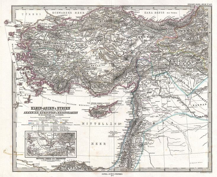
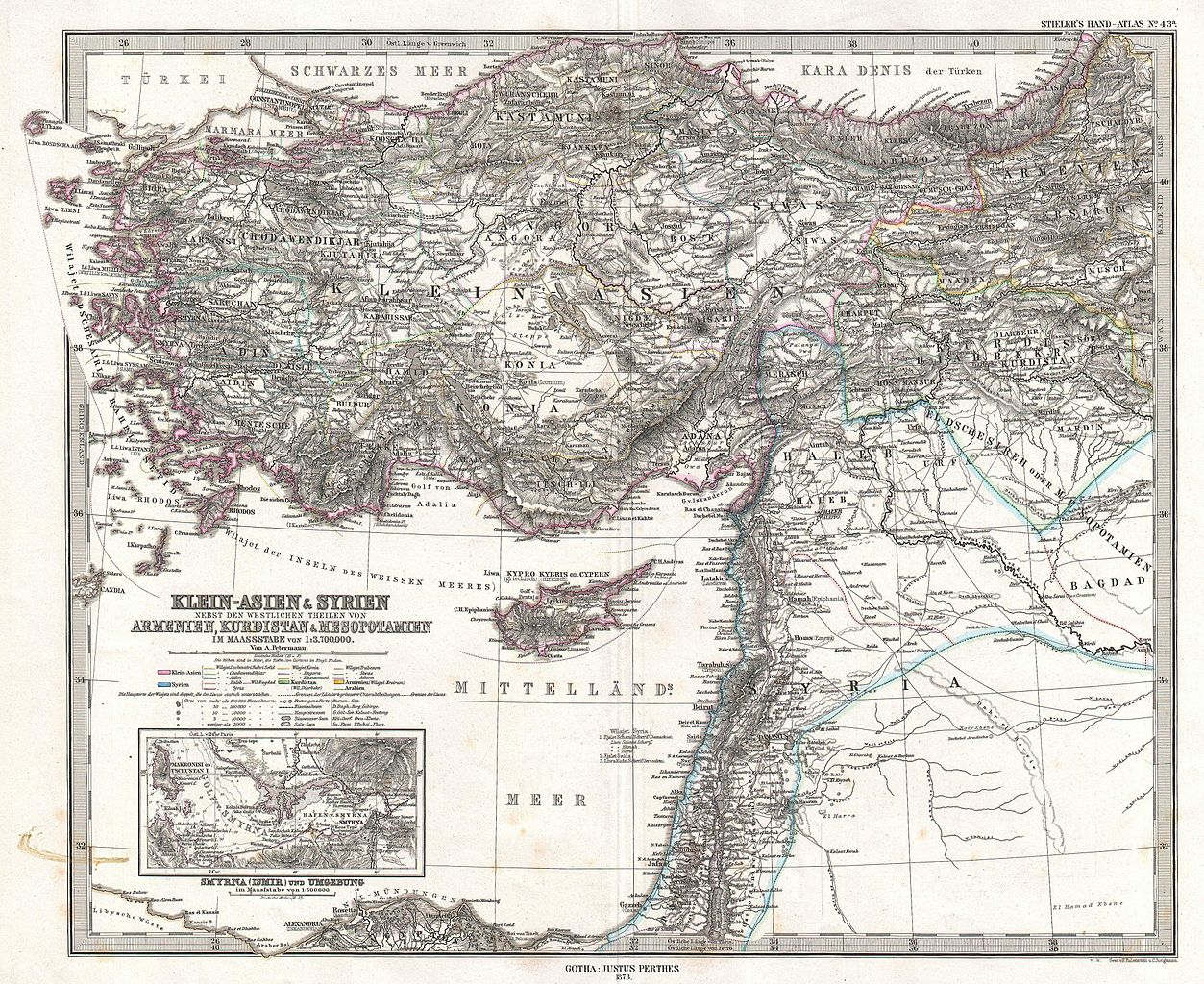
| Justus Perthes: Klein-Asien & Syrien nebst Den Westlichen Theilen von Armenien, Kurdistan & Mesopotamien.
( |
|||||||||||||||||||||||||||
|---|---|---|---|---|---|---|---|---|---|---|---|---|---|---|---|---|---|---|---|---|---|---|---|---|---|---|---|
| فن کار |
|
||||||||||||||||||||||||||
| عنوان |
Klein-Asien & Syrien nebst Den Westlichen Theilen von Armenien, Kurdistan & Mesopotamien. |
||||||||||||||||||||||||||
| تفصیل |
English: This is a beautiful example of Stieler’s 1873 map of the modern day Turkey, Syria, Israel / Palestine and Cyprus. Highly detailed with both political and physical data. Shows cities, mountains, roads, rivers and local divisions. An inset in the lower left quadrant features the vicinity of Smyrna (modern Ismir), including depth sounding in the Gulf of Smyrna and harbor. Printed to a high production standard, as was typical of German and especially Perthes/Stieler maps of this period. Published by the Justus Perthes firm and engraved by F. Eulenstein and C. Jungmann for issue as plate no. 43 in the 1873 edition of Stieler’s Hand-Atlas . |
||||||||||||||||||||||||||
| تاریخ | 1873 (dated) | ||||||||||||||||||||||||||
| ابعاد | اونچائی: 13.5 in (34.2 cm)؛ اونچائی: 16.6 in (42.1 cm) | ||||||||||||||||||||||||||
| اضافہ نمبر |
Geographicus link: Klein-AsienSyrien-stieler-1873 |
||||||||||||||||||||||||||
| ماخذ/مصور |
Stieler's Hand-Atlas (1873 issue).
|
||||||||||||||||||||||||||
| اجازت (فائل کا دوبارہ استعمال) |
|
||||||||||||||||||||||||||

_-_Geographicus_-_Klein-AsienSyrien-stieler-1873.jpg)
فائل کا تاریخچہ
کسی خاص وقت یا تاریخ میں یہ فائل کیسی نظر آتی تھی، اسے دیکھنے کے لیے اس وقت/تاریخ پر کلک کریں۔
| تاریخ/وقت | تھمب نیل | ابعاد | صارف | تبصرہ | |
|---|---|---|---|---|---|
| رائج الوقت | 08:02، 18 مارچ 2011ء | | 4,000 × 3,270 (3.79 MB) | BotMultichill | {{subst:User:Multichill/Geographicus |link=http://www.geographicus.com/P/AntiqueMap/Klein-AsienSyrien-stieler-1873 |product_name=1873 Stieler Map of Asia Minor, Syria and Israel - Palestine (modern Turkey) |map_title=Klein-Asien & Syrien nebst Den Westlic |
روابط
درج ذیل صفحہ اس فائل کو استعمال کر رہا ہے:
فائل کا عالمی استعمال
مندرجہ ذیل ویکیوں میں یہ فائل زیر استعمال ہے:
- ar.wikipedia.org پر استعمال
- az.wikipedia.org پر استعمال
- bn.wikipedia.org پر استعمال
- en.wikipedia.org پر استعمال
- eo.wikipedia.org پر استعمال
- it.wikipedia.org پر استعمال
- ko.wikipedia.org پر استعمال
- mk.wikipedia.org پر استعمال
- mt.wikipedia.org پر استعمال
- pnb.wikipedia.org پر استعمال
- sl.wikipedia.org پر استعمال
- tr.wikipedia.org پر استعمال
_-_Geographicus_-_Klein-AsienSyrien-stieler-1873.jpg)