
فائل:Germany (2), Neuwerk, Scharhörn, Nigehörn.jpg
اس نمائش کا حجم: 691 × 600 پکسلز۔ دیگر تصمیمات: 277 × 240 پکسلز | 553 × 480 پکسلز | 885 × 768 پکسلز | 1,180 × 1,024 پکسلز | 1,941 × 1,684 پکسلز۔
اصل فائل (1,941 × 1,684 پکسل، فائل کا حجم: 550 کلوبائٹ، MIME قسم: image/jpeg)
,_Neuwerk,_Scharh%C3%B6rn,_Nigeh%C3%B6rn.jpg)
خلاصہ
| تفصیل |
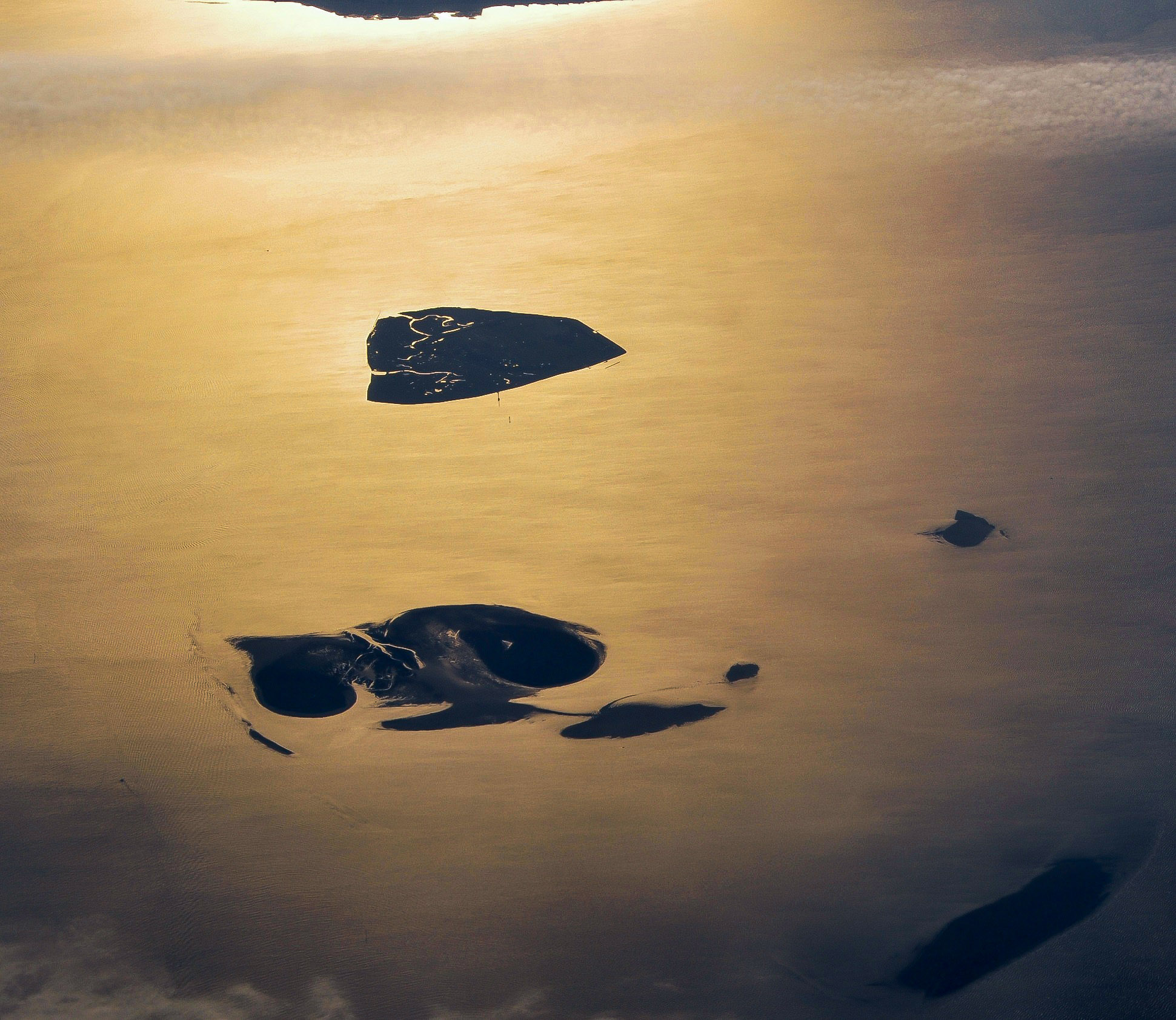
English: Aerial picture of the Hamburg Wadden Sea National Park (German: Nationalpark Hamburgisches Wattenmeer). This park is an exclave of the city state of Hamburg and lies 12.5 km off Cuxhaven in the estuary of the Elbe in the North Sea. The park includes the islands of Neuwerk (above), Scharhörn and Nigehörn (below, appearing as a single island in this picture taken at low tide). The two other islands (right and below right) are parts of the Scharhörn and Neuwerk mudflats (Scharhörner und Neuwerker Watt). Viewing direction is toward the SE.
Nederlands: Luchtfoto van het Hamburgse Nationale Park Waddenzee (Duits: Nationalpark Hamburgisches Wattenmeer). Dit park is een exclave van de stadstaat Hamburg en ligt 12.5 ten NW van Cuxhaven in de monding van de Elbe in de Noordzee. Het park omvat de eilanden Neuwerk (boven), Scharhörn en Nigehörn (die op de foto op één eiland lijken). De twee andere eilanden (rechts en rechts onder) zijn delen van het Scharhörnse en Neuwerkse Wad (Scharhörner und Neuwerker Watt). Blikrichting is naar het zuidoosten. |
| تاریخ | |
| ماخذ | ذاتی کام |
| مصنف | Vincent van Zeijst |
| اجازت (فائل کا دوبارہ استعمال) |
اس ملف کا لائسنس Creative Commons Attribution-Share Alike 3.0 Unported کے تحط ہے۔
|
| Camera location | | View this and other nearby images on: OpenStreetMap |
|---|
,_Neuwerk,_Scharh%C3%B6rn,_Nigeh%C3%B6rn.jpg¶ms=053.998083_N_0008.338622_E_globe:Earth_type:camera_region:DE_heading:135.00&language=ur)
| Annotations | This image is annotated: View the annotations at Commons |
فائل کا تاریخچہ
کسی خاص وقت یا تاریخ میں یہ فائل کیسی نظر آتی تھی، اسے دیکھنے کے لیے اس وقت/تاریخ پر کلک کریں۔
| تاریخ/وقت | تھمب نیل | ابعاد | صارف | تبصرہ | |
|---|---|---|---|---|---|
| رائج الوقت | 13:59، 27 دسمبر 2017ء | | 1,941 × 1,684 (550 کلوبائٹ) | Aeroid | dust removal |
| 16:59، 26 مارچ 2011ء |  | 1,941 × 1,684 (543 کلوبائٹ) | Loranchet | {{Information |Description ={{en|1=Aerial picture of the Hamburg Wadden Sea National Park (German: Nationalpark Hamburgisches Wattenmeer). This park is an exclave of the city state of Hamburg and lies 12.5 km off Cuxhaven in the estuary of the Elbe in |
روابط
درج ذیل صفحہ اس فائل کو استعمال کر رہا ہے:
فائل کا عالمی استعمال
مندرجہ ذیل ویکیوں میں یہ فائل زیر استعمال ہے:
- az.wikipedia.org پر استعمال
- ban.wikipedia.org پر استعمال
- de.wikipedia.org پر استعمال
- en.wikipedia.org پر استعمال
- fa.wikipedia.org پر استعمال
- hsb.wikipedia.org پر استعمال
- mk.wikipedia.org پر استعمال
- nl.wikipedia.org پر استعمال
- pl.wikipedia.org پر استعمال
- sv.wikipedia.org پر استعمال
- tr.wikipedia.org پر استعمال
- vi.wikipedia.org پر استعمال
- zh.wikipedia.org پر استعمال
,_Neuwerk,_Scharhörn,_Nigehörn.jpg)