
فائل:NEO lake jau big.jpg

اس نمائش کا حجم: 600 × 600 پکسلز۔ دیگر تصمیمات: 240 × 240 پکسلز | 480 × 480 پکسلز | 750 × 750 پکسلز۔
اصل فائل (750 × 750 پکسل، فائل کا حجم: 134 کلوبائٹ، MIME قسم: image/jpeg)
خلاصہ
| تفصیل |
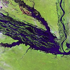
English: The Negro River flowing through the eastern edge of Brazil’s Jau National Park. The river is the big strip of blue running from left to right across the image, and the other blue ribbons are tributaries. Originating at the border of Venezuela and Brazil, the Negro River meets up with the Amazon in central Brazil to become its largest tributary. Half-submerged islands can be seen in the center of the river. Between November and April when the river is at its peak, many of these islands disappear. |
| تاریخ | |
| ماخذ |
http://earthobservatory.nasa.gov/Newsroom/NewImages/images.php3?img_id=10843
|
| مصنف | NASA and USGS EROS Data Center Satellite Systems Branch |
اجازہ کاری
This image is in the public domain in the United States because it only contains materials that originally came from the United States Geological Survey, an agency of the United States Department of the Interior. For more information, see the official USGS copyright policy.
|
اولین اپلوڈ کا نوشتہ
فائل کی تفصیلات کا اصل صفحہ یہاں تھا۔ درج ذیل تمام صارفین en.wikipedia کے ہیں۔
- 2003-11-23 05:55 Snoyes 750×750×8 (136760 bytes)
فائل کا تاریخچہ
کسی خاص وقت یا تاریخ میں یہ فائل کیسی نظر آتی تھی، اسے دیکھنے کے لیے اس وقت/تاریخ پر کلک کریں۔
| تاریخ/وقت | تھمب نیل | ابعاد | صارف | تبصرہ | |
|---|---|---|---|---|---|
| رائج الوقت | 20:27، 4 اپریل 2008ء | | 750 × 750 (134 کلوبائٹ) | File Upload Bot (Magnus Manske) | {{BotMoveToCommons|en.wikipedia}} {{Information |Description={{en|'''Credit(s):''' [http://edc.usgs.gov/ USGS EROS Data Center] Satellite Systems Branch. '''Source:''' http://earthobservatory.nasa.gov/Newsroom/NewImages/images.php3?img_id=10843 ''?The |
روابط
درج ذیل صفحہ اس فائل کو استعمال کر رہا ہے:
فائل کا عالمی استعمال
مندرجہ ذیل ویکیوں میں یہ فائل زیر استعمال ہے:
- ar.wikipedia.org پر استعمال
- ast.wikipedia.org پر استعمال
- ba.wikipedia.org پر استعمال
- be.wikipedia.org پر استعمال
- bg.wikipedia.org پر استعمال
- ca.wikipedia.org پر استعمال
- de.wikipedia.org پر استعمال
- de.wikivoyage.org پر استعمال
- en.wikipedia.org پر استعمال
- es.wikipedia.org پر استعمال
- eu.wikipedia.org پر استعمال
- fr.wikipedia.org پر استعمال
- he.wikipedia.org پر استعمال
- he.wikivoyage.org پر استعمال
- hi.wikipedia.org پر استعمال
- hr.wikipedia.org پر استعمال
- id.wikipedia.org پر استعمال
- it.wikivoyage.org پر استعمال
- ja.wikipedia.org پر استعمال
- ka.wikipedia.org پر استعمال
- ko.wikipedia.org پر استعمال
- lt.wikipedia.org پر استعمال
- mai.wikipedia.org پر استعمال
- ml.wikipedia.org پر استعمال
- mt.wikipedia.org پر استعمال
- ne.wikipedia.org پر استعمال
- nl.wikipedia.org پر استعمال
- pl.wikipedia.org پر استعمال
اس فائل کا مزید عالمی استعمال دیکھیے۔