
فائل:Persia 1814.jpg
اس نمائش کا حجم: 718 × 600 پکسلز۔ دیگر تصمیمات: 287 × 240 پکسلز | 575 × 480 پکسلز | 920 × 768 پکسلز | 1,226 × 1,024 پکسلز | 2,452 × 2,048 پکسلز | 2,931 × 2,448 پکسلز۔
اصل فائل (2,931 × 2,448 پکسل، فائل کا حجم: 1.6 MB، MIME قسم: image/jpeg)
خلاصہ
| وضاحت |
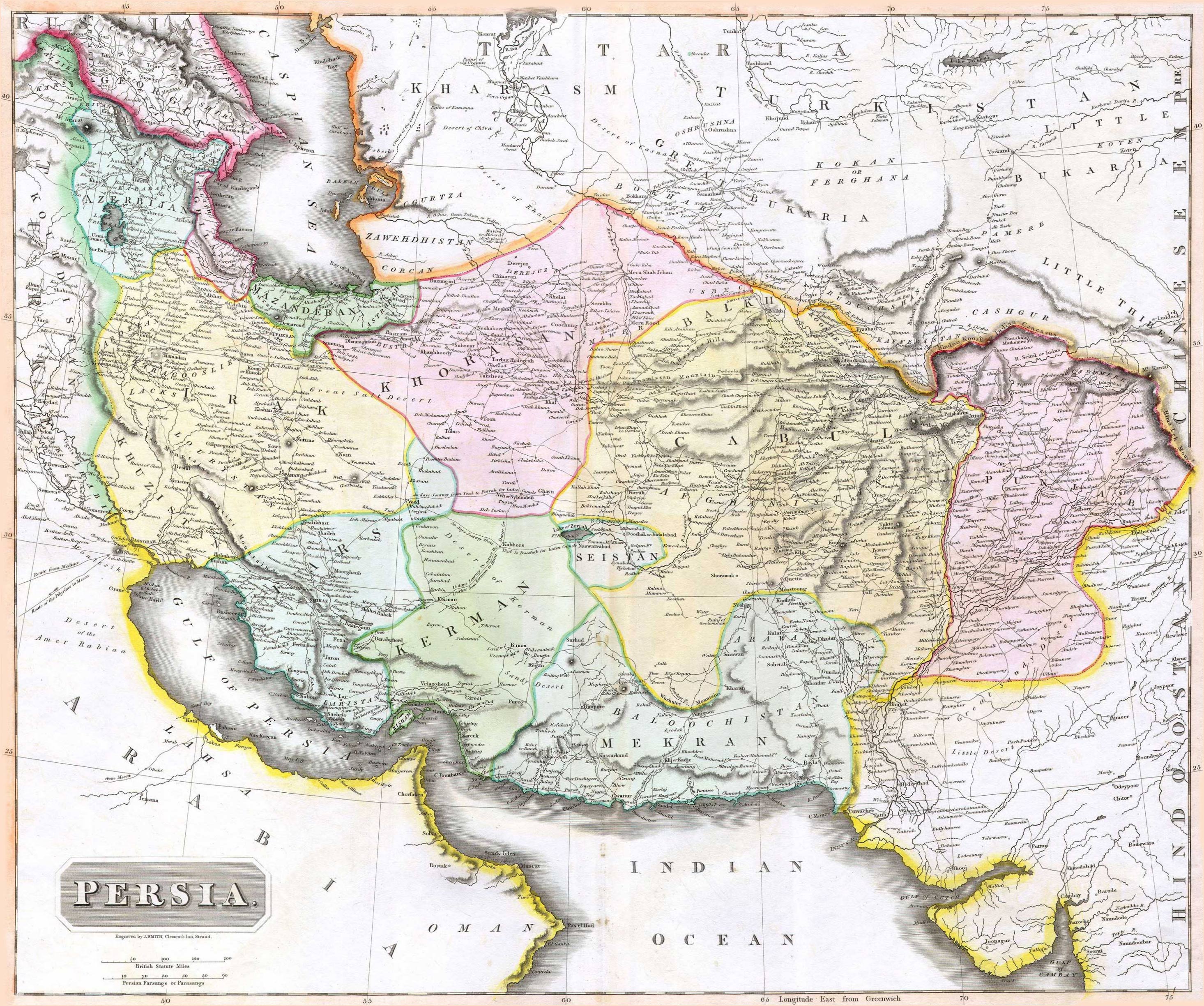
English: 1814 Thomson Map of Persia (Iran), engraved by J. Smith, Clement's Inn, Strand. |
| تاریخ | |
| خالق |
J. Smith, Clement's Inn, Strand. |
| Geotemporal data | |
| Map location | Iran |
| Georeferencing | If inappropriate please set warp_status = skip to hide. |
| Bibliographic data | |
| مطبوعہ |
New General Atlas (1821) |
| مصنف |
John Thomson |
| دوسرے نسخے | |

اجازہ کاری
The copyright situation of this work is theoretically uncertain, because in the country of origin copyright lasts 70 years after the death of the author, and the date of the author's death is unknown. However, the date of creation of the work was over 120 years ago, and it is thus a reasonable assumption that the copyright has expired (see here for the community discussion). Do not use this template if the date of death of the author is known.
This work is in the public domain in the United States because it was published (or registered with the U.S. Copyright Office) before January 1, 1929. | |
| This file has been identified as being free of known restrictions under copyright law, including all related and neighboring rights. | |
فائل کا تاریخچہ
کسی خاص وقت یا تاریخ میں یہ فائل کیسی نظر آتی تھی، اسے دیکھنے کے لیے اس وقت/تاریخ پر کلک کریں۔
| تاریخ/وقت | تھمب نیل | ابعاد | صارف | تبصرہ | |
|---|---|---|---|---|---|
| رائج الوقت | 07:27، 18 اگست 2010ء | | 2,931 × 2,448 (1.6 MB) | Begoon | edge perspective and crop |
| 02:35، 19 نومبر 2006ء |  | 2,979 × 2,520 (1.45 MB) | Kaveh | == Summary == 1814 Thomson Map of Persia (Iran) Category:Maps of Iran == Licensing == {{PD-old}} |
روابط
درج ذیل 2 صفحات اس فائل کو استعمال کر رہے ہیں:
فائل کا عالمی استعمال
مندرجہ ذیل ویکیوں میں یہ فائل زیر استعمال ہے:
- ar.wikipedia.org پر استعمال
- az.wikipedia.org پر استعمال
- be.wikipedia.org پر استعمال
- bn.wikipedia.org پر استعمال
- bs.wikipedia.org پر استعمال
- ca.wikipedia.org پر استعمال
- da.wikipedia.org پر استعمال
- de.wikipedia.org پر استعمال
- en.wikipedia.org پر استعمال
- es.wikipedia.org پر استعمال
- eu.wikipedia.org پر استعمال
- fa.wikipedia.org پر استعمال
- fr.wikipedia.org پر استعمال
- hi.wikipedia.org پر استعمال
- hr.wikipedia.org پر استعمال
اس فائل کا مزید عالمی استعمال دیکھیے۔