
فائل:Persia 600ad.jpg
اصل فائل (1,098 × 623 پکسل، فائل کا حجم: 644 کلوبائٹ، MIME قسم: image/jpeg)
Rest

|
This historical map image could be re-created using vector graphics as an SVG file. This has several advantages; see Commons:Media for cleanup for more information. If an SVG form of this image is available, please upload it and afterwards replace this template with
{{vector version available|new image name}}.
It is recommended to name the SVG file “Persia 600ad.svg”—then the template Vector version available (or Vva) does not need the new image name parameter. |


خلاصہ
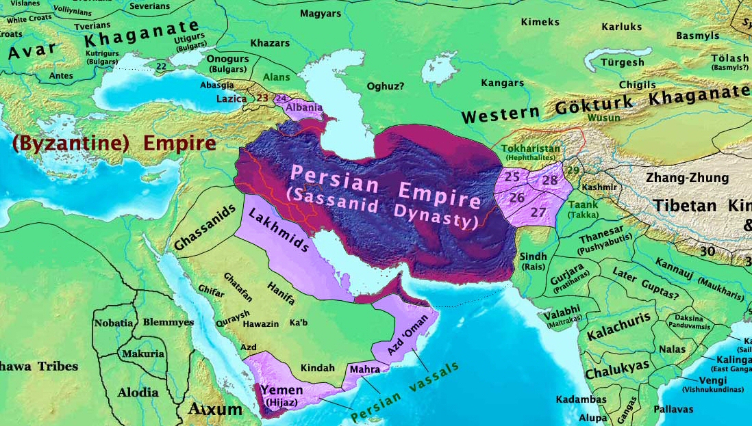
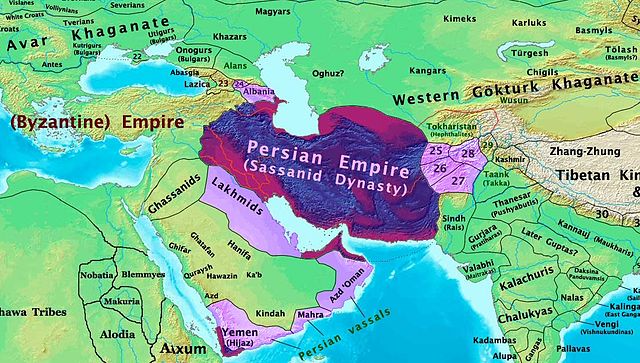
| تفصیل | The Persian Sassanid Empire in 600 AD. |
| تاریخ | |
| ماخذ | ذاتی کام |
| مصنف | Thomas Lessman (Contact!) |
| اجازت (فائل کا دوبارہ استعمال) |
میں اس تخلیقی کام کے حقوق کا مالک ہوں اور اسے مندرجہ ذیل اجازت نامے کے تحت شائع کرتا ہوں: اس ملف کا لائسنس Creative Commons Attribution-Share Alike 3.0 Unported کے تحط ہے۔
|
| دوسرے نسخے | see below |
Map Summary

Original Source URL: http://www.thomaslessman.com/History/images/East-Hem_600ad.jpg
This map is a zoomed-in version of Thomas Lessman's map of the
East-Hem_600ad.jpg (also available at www.WorldHistoryMaps.info).
The highlighted areas represent the Persian Sassanid Empire and its territories in the year 600 AD (before the Great Romano-Persian war).
Map Source References
Remember, sources often conflict with each other. This map is only as accurate as the information that is available to me. To report any errors or to help further this work, please click here, or email Thomas Lessman at talessman@yis.us
References for information contained in this map:
Other Maps by Thomas Lessman
| Maps of the eastern hemisphere showing history
Bold dates are available on Wikimedia or Wikipedia. | ||
| Primeval | ||
| Ancient
|
·| 600 BC | 550 BC | 527 BC | 500 BC |
400 BC | ·| 1 AD | 50 AD | 100 AD | 200 AD | 300 AD | | |
| Medieval |
·| 500 AD | 565 AD | 600 AD | 700 AD | | |
| Modern |
·| 1500 AD | · * For historical maps of the whole world, | |
Other Info
اولین اپلوڈ کا نوشتہ
- 2008-01-30 00:27 Talessman 1724×814×8 (267093 bytes) This image is a zoomed-in version of [http://en.wikipedia.org/wiki/Image:East-Hem_600ad.jpg Eastern Hemisphere in 600 AD]. The highlighted area is the Persian Sassanid Empire. [[Image:East-Hem_600ad.jpg|thumb|300px|left|Eastern Hemisphere in 600 AD.]] Author: T
فائل کا تاریخچہ
کسی خاص وقت یا تاریخ میں یہ فائل کیسی نظر آتی تھی، اسے دیکھنے کے لیے اس وقت/تاریخ پر کلک کریں۔
| تاریخ/وقت | تھمب نیل | ابعاد | صارف | تبصرہ | |
|---|---|---|---|---|---|
| رائج الوقت | 19:44، 7 دسمبر 2015ء | | 1,098 × 623 (644 کلوبائٹ) | B | Removed obnoxious label |
| 21:00، 21 اگست 2008ء |  | 1,098 × 623 (813 کلوبائٹ) | Talessman | Updated version of the parent map. This new version features colored areas to highlight the Persian Empire and its vassal states. | |
| 17:25، 28 اپریل 2008ء |  | 1,724 × 814 (261 کلوبائٹ) | Producer | {{Information |Description={{en|This image is a zoomed-in version of [http://en.wikipedia.org/wiki/Image:East-Hem_600ad.jpg Eastern Hemisphere in 600 AD]. The highlighted area is the Sassanid Persian Empire. [[:en:Image:East-Hem_600ad.jpg|thumb|300px|lef |
روابط
درج ذیل صفحہ اس فائل کو استعمال کر رہا ہے:
فائل کا عالمی استعمال
مندرجہ ذیل ویکیوں میں یہ فائل زیر استعمال ہے:
- ar.wikipedia.org پر استعمال
- as.wikipedia.org پر استعمال
- azb.wikipedia.org پر استعمال
- bn.wikipedia.org پر استعمال
- ca.wikipedia.org پر استعمال
- cs.wikipedia.org پر استعمال
- de.wikipedia.org پر استعمال
- el.wikipedia.org پر استعمال
- en.wikipedia.org پر استعمال
- es.wikipedia.org پر استعمال
- fa.wikipedia.org پر استعمال
- fr.wikipedia.org پر استعمال
- hi.wikipedia.org پر استعمال
- hy.wikipedia.org پر استعمال
- hyw.wikipedia.org پر استعمال
- id.wikipedia.org پر استعمال
- incubator.wikimedia.org پر استعمال
- is.wikipedia.org پر استعمال
- it.wikipedia.org پر استعمال
- ja.wikipedia.org پر استعمال
- ka.wikipedia.org پر استعمال
اس فائل کا مزید عالمی استعمال دیکھیے۔