
فائل:Roanoke map 1584.JPG
اس نمائش کا حجم: 293 × 598 پکسلز۔ دیگر تصمیمات: 117 × 240 پکسلز | 235 × 480 پکسلز | 648 × 1,323 پکسلز۔
اصل فائل (648 × 1,323 پکسل، فائل کا حجم: 466 کلوبائٹ، MIME قسم: image/jpeg)
خلاصہ
| تفصیل |
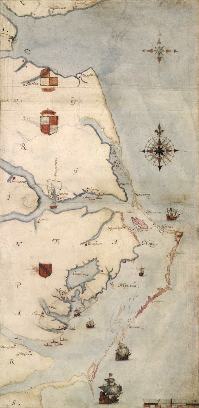
1585 map of the east coast of North America from the Chesapeake Bay to Cape Lookout by John White. Nederlands: Een kaart van het Roanoke-gebied, door John White |
|||||||||||||||||||||||
| تاریخ | بین 1,585.0 و 1,593.0 | |||||||||||||||||||||||
| ماخذ | A British Museum photograph of the map. [1] | |||||||||||||||||||||||
| مصنف |
|
|||||||||||||||||||||||

| This is a retouched picture, which means that it has been digitally altered from its original version. Modifications: cropped and slight levels adjustment. Modifications made by Earthsound.
|
اجازہ کاری
|
This is a faithful photographic reproduction of a two-dimensional, public domain work of art. The work of art itself is in the public domain for the following reason:
The official position taken by the Wikimedia Foundation is that "faithful reproductions of two-dimensional public domain works of art are public domain".
This photographic reproduction is therefore also considered to be in the public domain in the United States. In other jurisdictions, re-use of this content may be restricted; see Reuse of PD-Art photographs for details. | ||||
فائل کا تاریخچہ
کسی خاص وقت یا تاریخ میں یہ فائل کیسی نظر آتی تھی، اسے دیکھنے کے لیے اس وقت/تاریخ پر کلک کریں۔
| تاریخ/وقت | تھمب نیل | ابعاد | صارف | تبصرہ | |
|---|---|---|---|---|---|
| رائج الوقت | 14:08، 10 جولائی 2013ء | | 648 × 1,323 (466 کلوبائٹ) | Earthsound | higher resolution version |
| 01:56، 8 اکتوبر 2009ء |  | 373 × 767 (59 کلوبائٹ) | Multixfer | Higher resolution | |
| 17:43، 7 اپریل 2005ء |  | 161 × 326 (16 کلوبائٹ) | Ary29 | 1584 map by John White of Chesapeake Bay to Cape Lookout. {{PD}} Source: en:Image:Ronokmap.JPG Category:Maps of the United States |
روابط
درج ذیل صفحہ اس فائل کو استعمال کر رہا ہے:
فائل کا عالمی استعمال
مندرجہ ذیل ویکیوں میں یہ فائل زیر استعمال ہے:
- ar.wikipedia.org پر استعمال
- arz.wikipedia.org پر استعمال
- az.wikipedia.org پر استعمال
- be.wikipedia.org پر استعمال
- bg.wikipedia.org پر استعمال
- de.wikipedia.org پر استعمال
- en.wikipedia.org پر استعمال
- Thirteen Colonies
- 1580s
- 1584
- John White (colonist and artist)
- Roanoke Colony
- List of North Carolina hurricanes (pre-1900)
- Portal:Tropical cyclones/Featured article/List of North Carolina hurricanes (pre-1900)
- Core Banks, North Carolina
- Simon Fernandes
- Raid on St. Augustine
- Wikipedia:Top 25 Report/September 11 to 17, 2016
- Wikipedia:Wikipedia Signpost/2016-09-29/Traffic report
- Wikipedia:Top 25 Report/September 18 to 24, 2016
- Wikipedia:Wikipedia Signpost/Single/2016-09-29
- eo.wikipedia.org پر استعمال
- es.wikipedia.org پر استعمال
- fi.wikipedia.org پر استعمال
- fr.wikipedia.org پر استعمال
- he.wikipedia.org پر استعمال
- hu.wikipedia.org پر استعمال
- hy.wikipedia.org پر استعمال
- is.wikipedia.org پر استعمال
- it.wikipedia.org پر استعمال
- ja.wikipedia.org پر استعمال
- ko.wikipedia.org پر استعمال
- mk.wikipedia.org پر استعمال
- ml.wikipedia.org پر استعمال
- nl.wikipedia.org پر استعمال
- no.wikipedia.org پر استعمال
- nrm.wikipedia.org پر استعمال
- pl.wikipedia.org پر استعمال
اس فائل کا مزید عالمی استعمال دیکھیے۔