
فائل:Border USA Mexico.jpg

اس نمائش کا حجم: 800 × 550 پکسلز۔ دیگر تصمیمات: 320 × 220 پکسلز | 640 × 440 پکسلز | 1,024 × 704 پکسلز | 1,280 × 880 پکسلز | 2,560 × 1,760 پکسلز | 3,600 × 2,475 پکسلز۔
اصل فائل (3,600 × 2,475 پکسل، فائل کا حجم: 6.69 MB، MIME قسم: image/jpeg)
خلاصہ
| تفصیل |
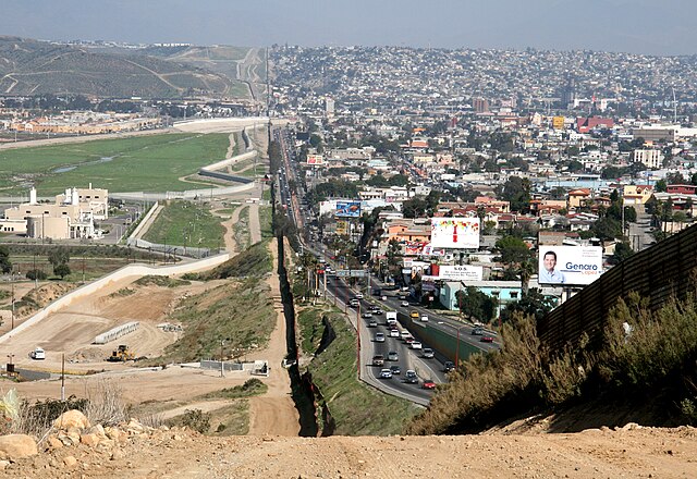
English: A small fence separates densely-populated Tijuana, Mexico, right, from the United States in the Border Patrol's San Diego Sector. Construction is underway to extend a secondary fence over the top of this hill and eventually to the Pacific Ocean.
Español: Una cerca pequeña separa Tijuana, México densamente poblada, a la derecha, de Estados Unidos en el Sector de San Diego de la Patrulla Fronteriza. Se construye una cerca secundaria que irá encima de esta colina y al fin seguirá al océano Pacífico.
Deutsch: Ein kleiner Zaun trennt das dicht bevölkerte Tijuana in Mexiko, im Bild auf der rechten Seite zu sehen, von den Vereinigte Staaten von Amerika in der Region um San Diego. Der Grenzschutz mit weiteren Zäunen wird bis zum Pazifischer Ozean ausgebaut.
Português: Um muro baixo separa a densamente povoada cidade de Tijuana, no México, à direita, dos Estados Unidos no sector fronteiriço de São Diego. Está em curso a construção de uma vedação secundária que se estenderá do cimo da colina e que deverá estender-se até ao Oceano Pacífico.
Français : Une petite clôture sépare le populeux Tijuana (Mexique) à droite, des États-Unis, dans le secteur de San Diego de l'United States Border Patrol. La construction est en cours afin de rallonger une clôture secondaire par-dessus cette colline et finalement à l'océan Pacifique.
Suomi: Yhdysvaltain ja Meksikon välinen raja. Kuvassa vasemmalla Yhdysvaltain Kaliforniaa ja oikealla Meksikon Tijuanaa.
Русский: Небольшой забор в центре фотографии разделяет густонаселённый мексиканский город Тихуана, расположенный справа, и американский город Сан-Диего, расположенный слева. |
| تاریخ | |
| ماخذ | http://www.ngb.army.mil |
| مصنف | Sgt. 1st Class Gordon Hyde |
| Camera location | | View this and other nearby images on: OpenStreetMap |
|---|
اجازہ کاری
This image is a work of a U.S. military or Department of Defense employee, taken or made as part of that person's official duties. As a work of the U.S. federal government, the image is in the public domain in the United States.
|
 |
Assessment
|
This image was selected as picture of the day on Vietnamese Wikipedia.
|
| Annotations | This image is annotated: View the annotations at Commons |
فائل کا تاریخچہ
کسی خاص وقت یا تاریخ میں یہ فائل کیسی نظر آتی تھی، اسے دیکھنے کے لیے اس وقت/تاریخ پر کلک کریں۔
| تاریخ/وقت | تھمب نیل | ابعاد | صارف | تبصرہ | |
|---|---|---|---|---|---|
| رائج الوقت | 00:01، 24 اگست 2007ء | | 3,600 × 2,475 (6.69 MB) | Wikifreund | {{Information |Description=A small fence separates densely populated Tijuana, Mexico, right, from the United States in the Border Patrol's San Diego Sector. Construction is underway to extend a secondary fence over the top of this hill and eventually to t |
روابط
درج ذیل 3 صفحات اس فائل کو استعمال کر رہے ہیں:
فائل کا عالمی استعمال
مندرجہ ذیل ویکیوں میں یہ فائل زیر استعمال ہے:
- af.wikipedia.org پر استعمال
- ar.wikipedia.org پر استعمال
- arz.wikipedia.org پر استعمال
- ast.wikipedia.org پر استعمال
- ba.wikipedia.org پر استعمال
- ca.wikipedia.org پر استعمال
- ceb.wikipedia.org پر استعمال
- cs.wikipedia.org پر استعمال
- de.wikipedia.org پر استعمال
- San Diego
- Tijuana
- San Diego County
- Grenze zwischen den Vereinigten Staaten und Mexiko
- Mexiko
- Portal:Mauern und Grenzen
- Benutzer:WA1TF0R/Galerie
- Tijuana-Kartell
- Wikipedia:Café/Archiv 2015 Q2
- Rassismus in den Vereinigten Staaten
- Wikipedia:Café/Archiv 2016 Q4
- Diskussion:Andreas Scheuer/Archiv
- El Salón México
- Wikipedia:Auskunft/Archiv/2019/Woche 22
- de.wiktionary.org پر استعمال
- en.wikipedia.org پر استعمال
- Mexico–United States border wall
- Mexico–United States border
- Talk:Mexico–United States border
- United States
- Mexico
- Metropolitan areas of Mexico
- San Diego–Tijuana
- Wikipedia:Featured pictures/Places/Others
- Wikipedia:WikiProject United States/Recognized content
- San Diego County, California
- Wikipedia:WikiProject United States/Quality content
- Wikipedia:Featured pictures thumbs/29
- Wikipedia:Featured picture candidates/Border Mexico USA.jpg
- Wikipedia:Featured picture candidates/January-2012
- Wikipedia:Wikipedia Signpost/2012-01-16/Featured content
- Global apartheid
- User talk:Morogris/Archive 1
- Wikipedia:Picture of the day/April 2013
- Template:POTD/2013-04-15
- Wikipedia:Main Page history/2013 April 15
اس فائل کا مزید عالمی استعمال دیکھیے۔